Чезана-Торинезе (Cesana Torinese, Cesana Torinese)

- коммуна Италии
 Hiking in Чезана-Торинезе
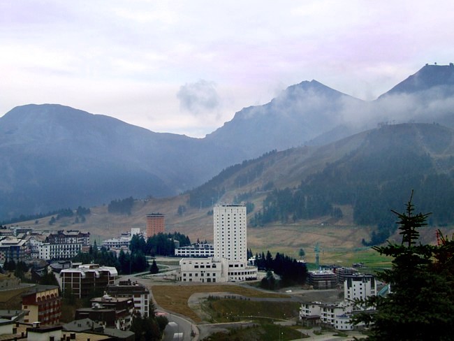
Cesana Torinese is a picturesque village located in the Susa Valley in the Piedmont region of Italy, within the Italian Alps. Known for its stunning natural beauty, it offers a variety of hiking opportunities for all skill levels. Here are some key highlights and tips for hiking in this area:
Trail Options
-
Sentiero delle Vette: This is a classic high-altitude trail that offers breathtaking views of the surrounding peaks. The route leads you through alpine meadows and rocky terrain, and it can be quite challenging, suitable for experienced hikers.
-
Hike to the Rocca Sella: This trail takes you to one of the iconic viewpoints in the area. The hike is moderately challenging, featuring well-marked paths that ascend through forests and rocky areas.
-
Val contributo: A family-friendly hike that makes for an excellent day trip. The path is relatively easy and suitable for all ages, offering expansive views and opportunities to observe local flora and fauna.
-
Monte Chaberton: A more demanding hike, this route takes you to the summit of Monte Chaberton, where you can explore remnants of a historic fort. The views from the top are stunning, stretching over the surrounding valleys and mountain ranges.
Best Times to Hike
- Summer (June to September): This is the best season for hiking in Cesana Torinese, as the weather is generally mild and the trails are accessible. However, be prepared for sudden weather changes in the mountains.
- Autumn (October): The fall colors create a spectacular backdrop for hikes, and the weather is often still pleasant.
Preparation Tips
- Footwear: Wear sturdy hiking boots with good grip and ankle support. The terrain can be rocky and uneven.
- Gear: Bring a good backpack with essentials including water, snacks, a map or GPS device, and first aid supplies.
- Weather: Check the weather forecast before heading out. Conditions can change quickly in the mountains.
- Wildlife: Be respectful of wildlife. Keep a safe distance from animals and do not feed them.
Local Attractions
Aside from hiking, Cesana Torinese offers opportunities for mountain biking, skiing in winter, and enjoying local cuisine at charming mountain huts and restaurants. The area also boasts cultural sites, such as historic churches and local markets.
Getting There
Cesana Torinese is accessible by car, with parking available in various locations around the village. Public transportation options are available, though schedules may vary, especially in off-peak seasons.
Overall, Cesana Torinese is a beautiful destination for hikers seeking both challenging and leisurely trails, as well as the chance to immerse themselves in breathtaking alpine scenery and local culture. Happy hiking!
- Страна:

- Почтовый код: 10054
- Телефонный код: 0122
- Код автомобильного номера: TO
- Координаты: 44° 57' 0" N, 6° 48' 0" E


- GPS треки (wikiloc): [Ссылка]
- Высота над уровнем моря: 1354 м m
- Площадь: 121.7 кв.км
- Население: 945
- Веб сайт: http://www.comune.cesana.to.it
- Википедия русская: wiki(ru)
- Википедия английская: wiki(en)
- Википедия национальная: wiki(it)
- Хранилище Wikidata: Wikidata: Q9249
- Катеория в википедии: [Ссылка]
- код Freebase: [/m/0g6vbx]
- код GeoNames: Альт: [6537268]
- код VIAF: Альт: [299197159]
- ID отношения в OpenStreetMap: [43801]
- код темы Quora: [Cesana-Torinese]
- код TGN: [1044182]
- код Цифрового атласа Римской империи: [11066]
- код Pleiades: [167914]
- код ISTAT: 001074
- кадастровый код Италии: C564
Граничит с регионами:
Соз-ди-Чезана
- коммуна в Италии
Hiking in Соз-ди-Чезана
Sauze di Cesana is a charming alpine village located in the Susa Valley of Italy's Piedmont region. It's well-known for its stunning scenery, rich history, and a variety of outdoor activities, particularly hiking. Here’s an overview of what you can expect when hiking in this beautiful area:...
- Страна:
- Почтовый код: 10054
- Телефонный код: 0122
- Код автомобильного номера: TO
- Координаты: 44° 56' 0" N, 6° 52' 0" E
- GPS треки (wikiloc): [Ссылка]
- Площадь: 78.28 кв.км
- Население: 249
- Веб сайт: [Ссылка]

Сестриере
- коммуна в Италии
Hiking in Сестриере
Sestriere, located in the Italian Alps, is a fantastic destination for hiking enthusiasts. Situated at around 2,035 meters (6,676 feet), it is part of the Via Lattea (Milky Way) ski area and is known for its stunning mountain scenery, charming alpine villages, and extensive network of trails....
- Страна:
- Почтовый код: 10058
- Телефонный код: 0122
- Код автомобильного номера: TO
- Координаты: 44° 57' 0" N, 6° 53' 0" E
- GPS треки (wikiloc): [Ссылка]
- Высота над уровнем моря: 2035 м m
- Площадь: 25.92 кв.км
- Население: 928
- Веб сайт: [Ссылка]

Сервьер
- коммуна во Франции
Hiking in Сервьер
Cervières is a picturesque valley located in the Hautes-Alpes region of France, renowned for its stunning natural beauty, diverse landscapes, and rich cultural heritage. It offers a variety of hiking opportunities suited for all levels, from casual strolls to more challenging treks. Here are some highlights of hiking in this area:...
- Страна:

- Почтовый код: 05100
- Координаты: 44° 52' 11" N, 6° 43' 19" E
- GPS треки (wikiloc): [Ссылка]
- Площадь: 109.68 кв.км
- Население: 183

Абрье
- коммуна во Франции
Hiking in Абрье
Abriès is a charming alpine village located in the Queyras Regional Natural Park in the French Alps. It is an excellent destination for hiking enthusiasts due to its stunning landscapes, diverse flora and fauna, and a variety of trails suitable for all levels of hikers. Here's an overview of what you can expect when hiking in Abriès:...
- Страна:
- Почтовый код: 05460
- Координаты: 44° 47' 43" N, 6° 55' 38" E
- GPS треки (wikiloc): [Ссылка]
- Площадь: 77.13 кв.км
- Население: 306
- Веб сайт: [Ссылка]

Неваш
- коммуна во Франции
Hiking in Неваш
Névache, located in the Hautes-Alpes region of France, is a beautiful destination for hiking enthusiasts. Nestled in the Écrins National Park, Névache is known for its stunning landscapes, including alpine meadows, rugged mountains, and crystal-clear rivers. Here are some highlights and tips for hiking in the area:...
- Страна:
- Почтовый код: 05100
- Координаты: 45° 1' 7" N, 6° 36' 17" E
- GPS треки (wikiloc): [Ссылка]
- Площадь: 191.93 кв.км
- Население: 359
- Веб сайт: [Ссылка]


Клавьере
- коммуна Италии
Hiking in Клавьере
Claviere is a charming village located in the Susa Valley of the Piedmont region in Italy, on the border with France. It’s a popular destination for outdoor enthusiasts, especially those interested in hiking due to its stunning mountain scenery and extensive trail network. Here’s what you can expect when hiking in Claviere:...
- Страна:
- Почтовый код: 10050
- Телефонный код: 0122
- Код автомобильного номера: TO
- Координаты: 44° 56' 18" N, 6° 44' 56" E
- GPS треки (wikiloc): [Ссылка]
- Высота над уровнем моря: 1760 м m
- Площадь: 2.69 кв.км
- Население: 209
- Веб сайт: [Ссылка]

Монженевр
- коммуна во Франции
Hiking in Монженевр
Montgenèvre is a charming village located in the French Alps, right near the Italian border, and it's an excellent destination for hiking enthusiasts. The landscape is characterized by breathtaking mountain views, lush valleys, and a range of trails suitable for various skill levels. Here are some key points about hiking in Montgenèvre:...
- Страна:
- Почтовый код: 05100
- Координаты: 44° 55' 51" N, 6° 43' 16" E
- GPS треки (wikiloc): [Ссылка]
- Высота над уровнем моря: 1860 м m
- Площадь: 40.07 кв.км
- Население: 510
- Веб сайт: [Ссылка]

Улькс
- коммуна Италии
Hiking in Улькс
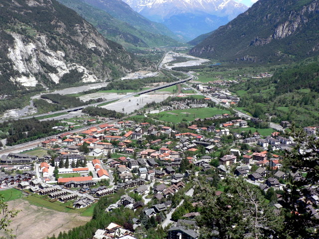
Oulx is a charming village located in the Susa Valley of the Italian Alps, and it’s a fantastic area for hiking enthusiasts. The region is known for its stunning mountain scenery, diverse trails, and opportunities for outdoor activities....
- Страна:
- Почтовый код: 10056
- Телефонный код: 0122
- Код автомобильного номера: TO
- Координаты: 45° 2' 0" N, 6° 50' 0" E
- GPS треки (wikiloc): [Ссылка]
- Высота над уровнем моря: 1100 м m
- Площадь: 99.79 кв.км
- Население: 3363
- Веб сайт: [Ссылка]