
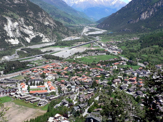
Сестриере (Sestriere, Sestriere)

- коммуна в Италии
 Hiking in Сестриере
Sestriere, located in the Italian Alps, is a fantastic destination for hiking enthusiasts. Situated at around 2,035 meters (6,676 feet), it is part of the Via Lattea (Milky Way) ski area and is known for its stunning mountain scenery, charming alpine villages, and extensive network of trails.
Hiking Trails
Sestriere offers a variety of hiking trails suited for all levels of hikers, from beginners to experienced mountaineers. Here are some popular trails:
-
Sentiero dell’Arrampicata (Climbing Path): Ideal for more experienced hikers, this trail combines walking with some climbing sections, offering breathtaking views of the surrounding mountains.
-
Colle del Sestriere: A moderate hike from Sestriere that provides picturesque views and the opportunity to see local flora and fauna. The trail can also lead you to scenic overlooks of the surrounding valleys.
-
Lake of Laune: A family-friendly hike that takes you to a beautiful alpine lake surrounded by mountains. This route is especially stunning in the summer when the wildflowers are in bloom.
-
The Parco Naturale della Val Troncea: Located a bit outside Sestriere, this natural park features numerous trails that take you through lush forests, past waterfalls, and offers the chance to see wildlife.
Best Time to Hike
The best time for hiking in Sestriere is typically from late spring (May) to early autumn (September). During this period, the weather is generally mild, and the trails are well-maintained. Snow can linger on higher trails until late June.
Tips for Hiking in Sestriere
- Gear Up: Sturdy hiking boots, weather-resistant clothing, and a good backpack with plenty of water and snacks are essential.
- Be Aware of Weather: The alpine weather can change quickly, so check forecasts and be prepared for sudden changes.
- Maps and Guides: Carry a detailed map of the trails or use GPS devices to stay on track.
- Leave No Trace: As in all natural areas, practice Leave No Trace principles to help preserve the beauty of the landscape.
Additional Activities
In addition to hiking, Sestriere offers activities such as mountain biking, horseback riding, and even paragliding for those seeking adventure from a different perspective.
Hiking in Sestriere combines the thrill of the outdoors with the charm of the Italian Alps, making it a memorable destination for hikers of all levels. Enjoy your time exploring this beautiful region!
- Страна:

- Почтовый код: 10058
- Телефонный код: 0122
- Код автомобильного номера: TO
- Координаты: 44° 57' 0" N, 6° 53' 0" E


- GPS треки (wikiloc): [Ссылка]
- Высота над уровнем моря: 2035 м m
- Площадь: 25.92 кв.км
- Население: 928
- Веб сайт: http://www.comune.sestriere.to.it/
- Википедия русская: wiki(ru)
- Википедия английская: wiki(en)
- Википедия национальная: wiki(it)
- Хранилище Wikidata: Wikidata: Q10302
- Галерея изображений в википедии: [Ссылка]
- Катеория в википедии: [Ссылка]
- код Freebase: [/m/071yc_]
- код GeoNames: Альт: [6540137]
- код VIAF: Альт: [244729748]
- ID отношения в OpenStreetMap: [43872]
- код GND: Альт: [4518461-6]
- идентификатор местоположения ArchINFORM: [1035]
- код TGN: [1046891]
- код ISTAT: 001263
- кадастровый код Италии: I692
Граничит с регионами:


Праджелато
- коммуна Италии
Hiking in Праджелато
Pragelato, located in the Susa Valley in the Piedmont region of Italy, is a fantastic destination for hiking enthusiasts. Nestled in the Alps, it is known for its stunning landscapes, diverse trails, and opportunities for outdoor activities year-round....
- Страна:
- Почтовый код: 10060
- Телефонный код: 0122
- Код автомобильного номера: TO
- Координаты: 45° 1' 0" N, 6° 57' 0" E
- GPS треки (wikiloc): [Ссылка]
- Высота над уровнем моря: 1518 м m
- Площадь: 89.2 кв.км
- Население: 786
- Веб сайт: [Ссылка]


Соз-д'Улькс
- коммуна в Италии
Hiking in Соз-д'Улькс
Sauze d'Oulx is a charming village located in the Susa Valley of the Piedmont region in Italy, and it's part of the Italian Alps. It's well known for its excellent skiing in the winter, but it also offers fantastic hiking opportunities during the warmer months. Here’s an overview of what to expect when hiking in and around Sauze d'Oulx:...
- Страна:
- Почтовый код: 10050
- Телефонный код: 0122
- Код автомобильного номера: TO
- Координаты: 45° 1' 36" N, 6° 51' 29" E
- GPS треки (wikiloc): [Ссылка]
- Высота над уровнем моря: 1510 м m
- Площадь: 17.31 кв.км
- Население: 1081
- Веб сайт: [Ссылка]
Соз-ди-Чезана
- коммуна в Италии
Hiking in Соз-ди-Чезана
Sauze di Cesana is a charming alpine village located in the Susa Valley of Italy's Piedmont region. It's well-known for its stunning scenery, rich history, and a variety of outdoor activities, particularly hiking. Here’s an overview of what you can expect when hiking in this beautiful area:...
- Страна:
- Почтовый код: 10054
- Телефонный код: 0122
- Код автомобильного номера: TO
- Координаты: 44° 56' 0" N, 6° 52' 0" E
- GPS треки (wikiloc): [Ссылка]
- Площадь: 78.28 кв.км
- Население: 249
- Веб сайт: [Ссылка]


Чезана-Торинезе
- коммуна Италии
Hiking in Чезана-Торинезе
Cesana Torinese is a picturesque village located in the Susa Valley in the Piedmont region of Italy, within the Italian Alps. Known for its stunning natural beauty, it offers a variety of hiking opportunities for all skill levels. Here are some key highlights and tips for hiking in this area:...
- Страна:
- Почтовый код: 10054
- Телефонный код: 0122
- Код автомобильного номера: TO
- Координаты: 44° 57' 0" N, 6° 48' 0" E
- GPS треки (wikiloc): [Ссылка]
- Высота над уровнем моря: 1354 м m
- Площадь: 121.7 кв.км
- Население: 945
- Веб сайт: [Ссылка]

Улькс
- коммуна Италии
Hiking in Улькс
Oulx is a charming village located in the Susa Valley of the Italian Alps, and it’s a fantastic area for hiking enthusiasts. The region is known for its stunning mountain scenery, diverse trails, and opportunities for outdoor activities....
- Страна:
- Почтовый код: 10056
- Телефонный код: 0122
- Код автомобильного номера: TO
- Координаты: 45° 2' 0" N, 6° 50' 0" E
- GPS треки (wikiloc): [Ссылка]
- Высота над уровнем моря: 1100 м m
- Площадь: 99.79 кв.км
- Население: 3363
- Веб сайт: [Ссылка]