Challes-les-Eaux (Challes-les-Eaux)

- коммуна во Франции
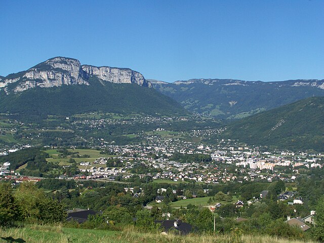
 Hiking in Challes-les-Eaux
Challes-les-Eaux, located in the Auvergne-Rhône-Alpes region of southeastern France, is known for its beautiful landscapes, thermal springs, and picturesque trails. The area offers a variety of hiking opportunities for all levels of fitness and experience. Here are some highlights about hiking in Challes-les-Eaux:
Trails and Scenery
-
Diverse Terrain: Hikers can expect diverse terrain that includes wooded areas, rolling hills, and beautiful views of the surrounding mountains and valleys. The nearby Chartreuse and Bauges mountains provide a stunning backdrop.
-
Marked Trails: The region features several well-marked hiking trails of varying difficulty. Whether you are looking for a leisurely walk or a more strenuous hike, there is something for everyone.
-
Thermal Springs: As a spa town, Challes-les-Eaux is famous for its thermal springs. Some hiking routes allow you to enjoy natural springs along the way, offering a chance to relax after a day of hiking.
-
Lakes and Rivers: The region has beautiful lakes and rivers that can be viewed from many trails, making for scenic picnic spots.
Popular Hiking Routes
- Sentier de la Roche: This is a popular trail that offers a moderately challenging hike with rewarding views from various lookout points.
- Les Boucles de Challes: A network of trails that encircle the town, suitable for both walking and cycling, providing flexibility in route choice.
Tips for Hiking in Challes-les-Eaux
- Check the Weather: The weather can change quickly in the mountains, so it’s essential to check conditions and dress accordingly.
- Stay Hydrated: Bring plenty of water, especially during warmer months.
- Footwear: Wear sturdy hiking shoes with good grip, as some trails may be rocky or uneven.
- Trail Maps: Although trails are generally well-marked, bringing a map or downloading a hiking app can be helpful.
- Local Regulations: Respect local wildlife and vegetation. Stick to marked trails and follow any guidelines provided by local authorities.
Attractions Nearby
After a day of hiking, consider exploring local attractions such as the thermal spa facilities or enjoying the local cuisine in town. Challes-les-Eaux is conveniently located near larger cities like Chambéry, which can also provide additional cultural experiences.
Overall, Challes-les-Eaux is a beautiful area for hiking, offering both natural beauty and the chance to explore the unique thermal spa culture of this region. Enjoy your hike!
- Страна:

- Почтовый код: 73190
- Координаты: 45° 32' 51" N, 5° 59' 2" E


- GPS треки (wikiloc): [Ссылка]
- Площадь: 5.65 кв.км
- Население: 5346
- Веб сайт: http://www.challes-les-eaux.fr
- Википедия английская: wiki(en)
- Википедия национальная: wiki(fr)
- Хранилище Wikidata: Wikidata: Q1234093
- Катеория в википедии: [Ссылка]
- Карты в википедии: [Ссылка]
- код Freebase: [/m/03qlm04]
- код GeoNames: Альт: [6450992]
- номер SIREN: [217300649]
- код BNF: [15273999r]
- код VIAF: Альт: [155229655]
- ID отношения в OpenStreetMap: [109273]
- код LCNAF: Альт: [nr98022013]
- WOEID: [12658777]
- код темы Quora: [Challes-les-Eaux]
- код муниципалитета INSEE: 73064
Граничит с регионами:


Myans
- коммуна во Франции
Hiking in Myans
It seems you may be referring to Myanmar, formerly known as Burma. Hiking in Myanmar offers a range of experiences, from lush forests and mountainous terrain to cultural trails that lead through villages and ancient ruins. Here are some notable hiking destinations and considerations for hiking in Myanmar:...
- Страна:
- Почтовый код: 73800
- Координаты: 45° 30' 53" N, 5° 59' 10" E
- GPS треки (wikiloc): [Ссылка]
- Площадь: 3.58 кв.км
- Население: 1200
- Веб сайт: [Ссылка]


Saint-Jeoire-Prieuré
- коммуна во Франции
Hiking in Saint-Jeoire-Prieuré
Saint-Jeoire-Prieuré is a charming village located in the Auvergne-Rhône-Alpes region of France, nestled within the beautiful French Alps. The area is a wonderful destination for hiking enthusiasts, offering a mix of scenic trails, stunning landscapes, and rich natural surroundings....
- Страна:
- Почтовый код: 73190
- Координаты: 45° 32' 5" N, 5° 59' 36" E
- GPS треки (wikiloc): [Ссылка]
- Площадь: 5.34 кв.км
- Население: 1432
- Веб сайт: [Ссылка]


Curienne
- коммуна во Франции
Hiking in Curienne
Curienne is a charming commune located in the Savoy department of the Auvergne-Rhône-Alpes region in southeastern France. While it may not be as well-known as some larger hiking destinations, it offers a serene environment and access to picturesque landscapes typical of the French Alps....
- Страна:
- Почтовый код: 73190
- Координаты: 45° 33' 58" N, 6° 0' 34" E
- GPS треки (wikiloc): [Ссылка]
- Площадь: 8.55 кв.км
- Население: 676
- Веб сайт: [Ссылка]

Ла Равуар
- коммуна во Франции
Hiking in Ла Равуар
La Ravoire, located in the Savoie department of the Auvergne-Rhône-Alpes region in southeastern France, offers a lovely setting for hiking enthusiasts. The area is characterized by its picturesque landscapes, combining rolling hills, lush forests, and stunning views of nearby mountain ranges....
- Страна:
- Почтовый код: 73490
- Координаты: 45° 33' 25" N, 5° 57' 59" E
- GPS треки (wikiloc): [Ссылка]
- Площадь: 6.82 кв.км
- Население: 8100
- Веб сайт: [Ссылка]


Barby, Savoie
Hiking in Barby, Savoie
Barby, located in the Savoie region of the French Alps, offers a variety of hiking opportunities set against a stunning backdrop of mountains and lush landscapes. Here are some key points to know about hiking in Barby:...
- Страна:
- Почтовый код: 73230
- Координаты: 45° 34' 18" N, 5° 58' 42" E
- GPS треки (wikiloc): [Ссылка]
- Площадь: 2.48 кв.км
- Население: 3408
- Веб сайт: [Ссылка]