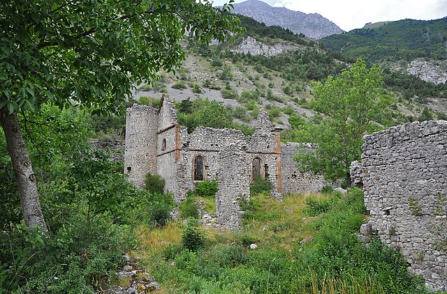
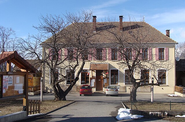
Шоффейе (Chauffayer, Chauffayer)
- коммуна во Франции
 Hiking in Шоффейе
Chauffayer is a charming commune located in the Hautes-Alpes department of southeastern France. It is surrounded by stunning mountainous landscapes, making it an appealing destination for hiking enthusiasts. Here are some highlights about hiking in and around Chauffayer:
Trails and Routes
-
Local Trails: Chauffayer features several well-marked hiking trails that cater to different skill levels. You can find peaceful routes through forests, along mountain streams, and offering stunning views of the surrounding peaks.
-
Trek to the Col de la Pisse: This is a popular hike that provides breathtaking panoramic views of the region and is suitable for hikers with moderate experience.
-
Explore the Ecrins National Park: Just a short drive from Chauffayer, the Ecrins National Park offers a vast array of trails that range from short walks to challenging multi-day treks. The park is known for its spectacular alpine scenery and diverse flora and fauna.
-
Lac de Pétarel: This beautiful lake can be accessed via a lovely hike and provides a great spot for a picnic and relaxation after your trek.
Best Times to Hike
- Spring and Summer: Typically the best seasons for hiking, with pleasant weather and blooming flora. Be mindful of snowpack in higher altitudes during early spring.
- Autumn: A beautiful time to hike as the foliage changes color, but be prepared for cooler temperatures.
Entry Requirements and Safety
- Stay on Designated Trails: To protect the environment and ensure your safety, stick to marked paths.
- Weather Awareness: Mountain weather can change rapidly, so always check forecasts before heading out and pack accordingly.
- Buddy System: Hike with a friend when possible, especially if you are on less-trafficked trails.
Equipment
- Footwear: Proper hiking boots with good ankle support are essential.
- Gear: Carry a daypack with water, snacks, first aid, and navigation tools (map, compass, or GPS).
- Clothing: Layered clothing is recommended to adapt to changing temperatures throughout the day.
Additional Tips
- Check Local Information: Before your hike, visit local tourist information centers for maps, trail conditions, and any guidance they may have.
- Respect Wildlife: Keep a respectful distance from any wildlife you encounter and follow Leave No Trace principles.
Whether you’re a novice or an experienced hiker, Chauffayer’s scenic trails will offer memorable outdoor experiences. Enjoy your adventure!
- Страна:

- Почтовый код: 05800
- Координаты: 44° 45' 15" N, 6° 0' 31" E


- GPS треки (wikiloc): [Ссылка]
- Площадь: 10.9 кв.км
- Население: 383
- Википедия русская: wiki(ru)
- Википедия английская: wiki(en)
- Википедия национальная: wiki(fr)
- Хранилище Wikidata: Wikidata: Q378841
- Катеория в википедии: [Ссылка]
- код Freebase: [/m/03mflcx]
- код Freebase: [/m/03mflcx]
- код GeoNames: Альт: [6446635]
- код GeoNames: Альт: [6446635]
- номер SIREN: [210500393]
- номер SIREN: [210500393]
- код муниципалитета INSEE: 05039
- код муниципалитета INSEE: 05039
Граничит с регионами:
Ле-Глезий
- коммуна во Франции
Hiking in Ле-Глезий
Le Glaizil is a picturesque commune located in the Hautes-Alpes department in southeastern France. The surrounding area is known for its stunning landscapes, including mountains, valleys, and diverse flora and fauna, which make it a great destination for hiking enthusiasts....
- Страна:
- Почтовый код: 05800
- Координаты: 44° 45' 13" N, 5° 58' 59" E
- GPS треки (wikiloc): [Ссылка]
- Площадь: 21.93 кв.км
- Население: 174

Сен-Жак-ан-Вальгодмар
- коммуна во Франции
Hiking in Сен-Жак-ан-Вальгодмар
Saint-Jacques-en-Valgodemard is a charming commune located in the Hautes-Alpes region of France, known for its breathtaking landscapes and exceptional hiking opportunities. Nestled in the Écrins National Park, this area is a haven for outdoor enthusiasts, offering a range of trails that cater to different skill levels....
- Страна:
- Почтовый код: 05800
- Координаты: 44° 46' 34" N, 6° 2' 38" E
- GPS треки (wikiloc): [Ссылка]
- Площадь: 15.65 кв.км
- Население: 147

Сен-Фирмен
- коммуна во Франции
Hiking in Сен-Фирмен
Saint-Firmin in the Hautes-Alpes region of France is a charming destination for hikers. Nestled in the Écrins National Park, this area is known for its stunning landscapes, rugged mountains, and rich biodiversity. Here are some key aspects to consider when hiking in and around Saint-Firmin:...
- Страна:
- Почтовый код: 05800
- Координаты: 44° 46' 53" N, 6° 1' 45" E
- GPS треки (wikiloc): [Ссылка]
- Высота над уровнем моря: 900 м m
- Площадь: 22.39 кв.км
- Население: 468
Сент-Эзеб-ан-Шансор
- коммуна во Франции
Hiking in Сент-Эзеб-ан-Шансор
Saint-Eusèbe-en-Champsaur is a picturesque village located in the French Alps, in the Champsaur valley. It offers a variety of hiking opportunities for both novice and experienced hikers. Here are some highlights of hiking in this area:...
- Страна:
- Почтовый код: 05500
- Координаты: 44° 43' 33" N, 6° 1' 39" E
- GPS треки (wikiloc): [Ссылка]
- Площадь: 7.83 кв.км
- Население: 150

Ле-Нуайе
- коммуна во Франции
Hiking in Ле-Нуайе
Le Noyer, located in the Hautes-Alpes region of southeastern France, is an excellent destination for hiking enthusiasts. This charming alpine village is situated near the Écrins National Park, which offers a diverse range of trails suitable for different skill levels, from beginners to more experienced hikers....
- Страна:
- Почтовый код: 05500
- Координаты: 44° 41' 55" N, 6° 0' 45" E
- GPS треки (wikiloc): [Ссылка]
- Площадь: 21.5 кв.км
- Население: 289

Ле-Кост
- коммуна во Франции
Hiking in Ле-Кост
Les Costes is a beautiful area that offers a range of hiking opportunities, characterized by its stunning landscapes and diverse terrain. While the specifics can vary depending on the exact location you're referring to, here's a general overview of what you might expect when hiking in a region like Les Costes:...
- Страна:
- Почтовый код: 05500
- Координаты: 44° 44' 46" N, 6° 2' 2" E
- GPS треки (wikiloc): [Ссылка]
- Площадь: 8.78 кв.км
- Население: 178