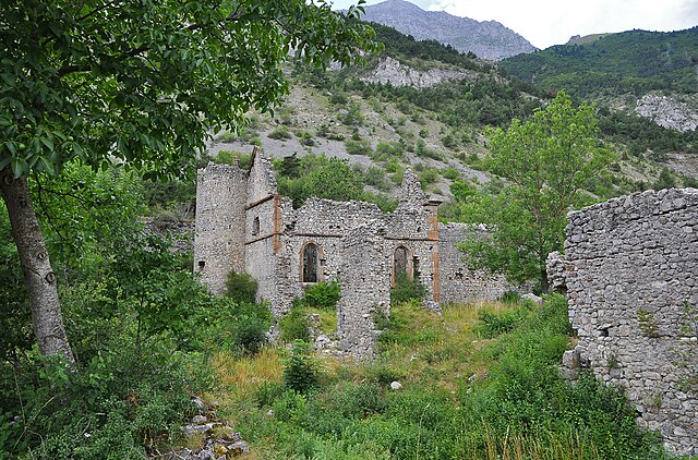
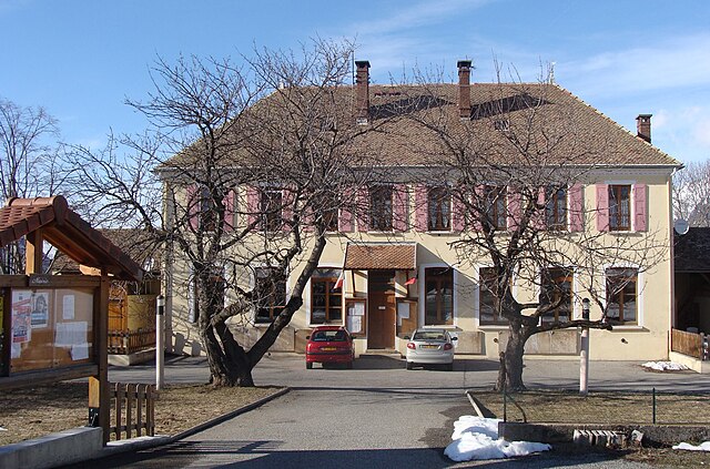
Ле-Нуайе (Le Noyer, Le Noyer)
- коммуна во Франции
 Hiking in Ле-Нуайе
Le Noyer, located in the Hautes-Alpes region of southeastern France, is an excellent destination for hiking enthusiasts. This charming alpine village is situated near the Écrins National Park, which offers a diverse range of trails suitable for different skill levels, from beginners to more experienced hikers.
Hiking Trails
-
Le Noyer to Col de l'Escudette: This hike offers stunning panoramic views of the surrounding peaks. The trail is moderately challenging and takes you through beautiful alpine meadows and forests.
-
Les Gorges de l'Orange: A relatively easier hike that takes you through picturesque gorges. It's a great choice for families or those looking for a shorter adventure.
-
Sentier du Puy de Bane: A more strenuous option, this trail leads to higher altitudes and rewards hikers with breathtaking views of the Écrins massif. Be prepared for some steep sections and rocky terrain.
-
Lac du Round: This hike leads to a serene mountain lake, perfect for a picnic. The trail is accessible and is suitable for hikers of all levels.
Best Time to Hike
The best time to hike in Le Noyer is from late spring to early autumn (May to September), when the weather is generally mild and the trails are clear of snow. However, local conditions can vary, so always check the weather forecast and prepare accordingly.
Preparation Tips
- Footwear: Wear sturdy hiking boots with good ankle support.
- Weather: Be prepared for sudden weather changes in the mountains. Layer your clothing and carry a waterproof jacket.
- Navigation: Although trails are usually well-marked, carrying a map or using a GPS app can help ensure you stay on track.
- Hydration and Snacks: Always carry enough water and energy-boosting snacks to keep you fueled throughout your hike.
Safety Considerations
- Always inform someone about your hiking route and expected return time.
- Familiarize yourself with the park's wildlife and any safety guidelines.
- Be cautious of altitude sickness if you're heading to higher elevations.
Local Attractions
In addition to hiking, Le Noyer offers opportunities for other outdoor activities such as mountain biking, paragliding, and skiing in the winter months. The local cuisine, featuring traditional alpine dishes, is also worth exploring after a day on the trails.
Hiking in Le Noyer can provide an unforgettable experience amidst stunning natural landscapes, making it a must-visit for anyone seeking outdoor adventure in the French Alps.
- Страна:

- Почтовый код: 05500
- Координаты: 44° 41' 55" N, 6° 0' 45" E


- GPS треки (wikiloc): [Ссылка]
- Площадь: 21.5 кв.км
- Население: 289
- Википедия русская: wiki(ru)
- Википедия английская: wiki(en)
- Википедия национальная: wiki(fr)
- Хранилище Wikidata: Wikidata: Q1087600
- Катеория в википедии: [Ссылка]
- код Freebase: [/m/03m81k5]
- код Freebase: [/m/03m81k5]
- код GeoNames: Альт: [6456670]
- код GeoNames: Альт: [6456670]
- номер SIREN: [210500955]
- номер SIREN: [210500955]
- код муниципалитета INSEE: 05095
- код муниципалитета INSEE: 05095
Граничит с регионами:
Ле-Глезий
- коммуна во Франции
Hiking in Ле-Глезий
Le Glaizil is a picturesque commune located in the Hautes-Alpes department in southeastern France. The surrounding area is known for its stunning landscapes, including mountains, valleys, and diverse flora and fauna, which make it a great destination for hiking enthusiasts....
- Страна:
- Почтовый код: 05800
- Координаты: 44° 45' 13" N, 5° 58' 59" E
- GPS треки (wikiloc): [Ссылка]
- Площадь: 21.93 кв.км
- Население: 174
Сент-Эзеб-ан-Шансор
- коммуна во Франции
Hiking in Сент-Эзеб-ан-Шансор
Saint-Eusèbe-en-Champsaur is a picturesque village located in the French Alps, in the Champsaur valley. It offers a variety of hiking opportunities for both novice and experienced hikers. Here are some highlights of hiking in this area:...
- Страна:
- Почтовый код: 05500
- Координаты: 44° 43' 33" N, 6° 1' 39" E
- GPS треки (wikiloc): [Ссылка]
- Площадь: 7.83 кв.км
- Население: 150
Полиньи
Hiking in Полиньи
Poligny, situated in the Hautes-Alpes region of southeastern France, is a fantastic destination for hikers, offering stunning landscapes, diverse trails, and a variety of outdoor activities....
- Страна:
- Почтовый код: 05500
- Координаты: 44° 41' 30" N, 6° 2' 50" E
- GPS треки (wikiloc): [Ссылка]
- Площадь: 13.81 кв.км
- Население: 302

Гап
- коммуна во Франции
Hiking in Гап
Gap, located in the Hautes-Alpes region of southeastern France, is a wonderful destination for hiking enthusiasts. Surrounded by majestic mountains and alpine landscapes, it offers a variety of trails that cater to all levels of hikers, from beginners to experienced trekkers....
- Страна:
- Почтовый код: 05000
- Координаты: 44° 33' 31" N, 6° 4' 40" E
- GPS треки (wikiloc): [Ссылка]
- Площадь: 110.43 кв.км
- Население: 40776
- Веб сайт: [Ссылка]
Деволюи
- коммуна во Франции
Hiking in Деволюи
Le Dévoluy is a stunning mountain range located in the French Alps, known for its diverse landscapes, breathtaking scenery, and extensive hiking opportunities. Whether you're an experienced hiker or a beginner, there's something for everyone in this area....
- Страна:
- Почтовый код: 05250
- Координаты: 44° 41' 33" N, 5° 56' 28" E
- GPS треки (wikiloc): [Ссылка]
- Площадь: 186.37 кв.км
- Население: 1011
- Веб сайт: [Ссылка]

Шоффейе
- коммуна во Франции
Hiking in Шоффейе
Chauffayer is a charming commune located in the Hautes-Alpes department of southeastern France. It is surrounded by stunning mountainous landscapes, making it an appealing destination for hiking enthusiasts. Here are some highlights about hiking in and around Chauffayer:...
- Страна:
- Почтовый код: 05800
- Координаты: 44° 45' 15" N, 6° 0' 31" E
- GPS треки (wikiloc): [Ссылка]
- Площадь: 10.9 кв.км
- Население: 383

Сент-Этьен-ан-Деволюи
- коммуна во Франции
Hiking in Сент-Этьен-ан-Деволюи
Saint-Étienne-en-Dévoluy is a lovely destination for hiking, located in the Dévoluy massif in the French Alps. This area offers a variety of trails suitable for all levels, from gentle walks to more challenging hikes, making it a perfect place for both beginners and experienced hikers....
- Страна:
- Почтовый код: 05250
- Координаты: 44° 41' 36" N, 5° 56' 31" E
- GPS треки (wikiloc): [Ссылка]
- Население: 525
- Веб сайт: [Ссылка]