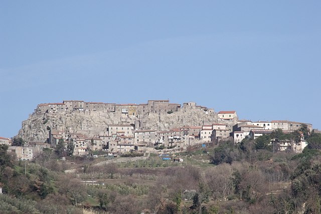
Кьюздино (Chiusdino, Chiusdino)
.svg)
- коммуна Италии
 Hiking in Кьюздино
Chiusdino is a charming village located in the Province of Siena in Tuscany, Italy, surrounded by beautiful landscapes that make it a fantastic destination for hiking enthusiasts. The area is rich in natural beauty, history, and culture, providing a great backdrop for outdoor activities.
Hiking Opportunities:
-
Nature Trails: There are various marked trails in and around Chiusdino that take you through lush forests, rolling hills, and picturesque vineyards. The terrain can vary from gentle slopes to more challenging heights, catering to different levels of hikers.
-
Monte Crevole: This peak offers some fantastic hiking opportunities with stunning panoramic views of the surrounding countryside. The trail to the summit can be a bit steep, but the vistas at the top make it worthwhile.
-
Cascate del Pavone: This natural waterfall is a beautiful spot for a hike, often reachable by scenic trails that wind through the forest. It's a lovely stop for a picnic or to enjoy the tranquility of nature.
-
Ancient Ruins and Monuments: While hiking, you can also discover historical landmarks such as the Abbey of San Galgano, which is well worth the detour. The abbey's ruins and the nearby sword in the stone are steeped in legend and history.
Things to Keep in Mind:
-
Trail Conditions: Check the trail conditions before heading out, especially in different weather seasons. Some paths may be more challenging during wet or wintery weather.
-
Local Guidance: Consider hiring a local guide or joining a hiking group for a more in-depth experience of the area. They can provide insights into flora and fauna, as well as the region's history.
-
Equipment: Proper footwear is essential, along with hydration packs, snacks, and a map of the area or a GPS device to help navigate.
-
Leave No Trace: As always, be sure to follow Leave No Trace principles to help preserve the natural beauty of Chiusdino for future hikers.
Overall, hiking in Chiusdino offers a combination of natural beauty, rich culture, and peaceful landscapes, making it an excellent choice for both casual walkers and seasoned hikers looking for adventure in Tuscany.
- Страна:

- Почтовый код: 53012
- Телефонный код: 0577
- Код автомобильного номера: SI
- Координаты: 43° 9' 17" N, 11° 5' 3" E


- GPS треки (wikiloc): [Ссылка]
- Высота над уровнем моря: 564 м m
- Площадь: 141.62 кв.км
- Население: 1877
- Веб сайт: http://www.comune.chiusdino.siena.it
- Википедия русская: wiki(ru)
- Википедия английская: wiki(en)
- Википедия национальная: wiki(it)
- Хранилище Wikidata: Wikidata: Q91176
- Галерея изображений в википедии: [Ссылка]
- Катеория в википедии: [Ссылка]
- код Freebase: [/m/0gm0r7]
- код GeoNames: Альт: [6536849]
- код VIAF: Альт: [145517126]
- ID отношения в OpenStreetMap: [42322]
- код GND: Альт: [4202395-6]
- идентификатор местоположения ArchINFORM: [1094]
- код ISTAT: 052010
- кадастровый код Италии: C661
Граничит с регионами:


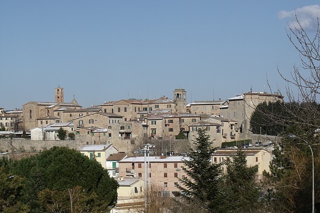
Монтиери
- коммуна Италии
Hiking in Монтиери
Montieri is a charming town located in the province of Grosseto in Tuscany, Italy. It's situated in a picturesque setting surrounded by lush forests, rolling hills, and scenic landscapes which make it a great destination for hikers and nature enthusiasts. Here are some key points about hiking in the Montieri area:...
- Страна:
- Почтовый код: 58026
- Телефонный код: 0566
- Код автомобильного номера: GR
- Координаты: 43° 7' 52" N, 11° 1' 0" E
- GPS треки (wikiloc): [Ссылка]
- Высота над уровнем моря: 704 м m
- Площадь: 108.21 кв.км
- Население: 1171
- Веб сайт: [Ссылка]

Роккастрада
- коммуна Италии
Hiking in Роккастрада
Roccastrada, located in the southern part of the Tuscany region in Italy, is an excellent destination for hiking enthusiasts. The area is characterized by its beautiful landscapes, rolling hills, and rich natural and cultural heritage. Here are some highlights to consider when hiking in Roccastrada:...
- Страна:
- Почтовый код: 58036
- Телефонный код: 0564
- Код автомобильного номера: GR
- Координаты: 43° 0' 35" N, 11° 10' 6" E
- GPS треки (wikiloc): [Ссылка]
- Высота над уровнем моря: 475 м m
- Площадь: 284.47 кв.км
- Население: 9074
- Веб сайт: [Ссылка]


Казоле-д'Эльса
- коммуна Италии
Hiking in Казоле-д'Эльса
Casole d'Elsa is a charming village located in the Tuscany region of Italy, known for its picturesque landscapes and rich historical heritage. Hiking in this area offers a unique opportunity to explore the natural beauty of the surrounding countryside, including rolling hills, vineyards, and fields of olive trees....
- Страна:
- Почтовый код: 53031
- Телефонный код: 0577
- Код автомобильного номера: SI
- Координаты: 43° 20' 28" N, 11° 2' 55" E
- GPS треки (wikiloc): [Ссылка]
- Высота над уровнем моря: 417 м m
- Площадь: 148.69 кв.км
- Население: 3852
- Веб сайт: [Ссылка]


Монтичано
- коммуна Италии
Hiking in Монтичано
Monticiano, a charming commune in the province of Siena, Tuscany, offers beautiful hiking opportunities amid stunning landscapes, historical sights, and diverse ecosystems. Here’s what you need to know about hiking in this region:...
- Страна:
- Почтовый код: 53015
- Телефонный код: 0577
- Код автомобильного номера: SI
- Координаты: 43° 8' 0" N, 11° 11' 0" E
- GPS треки (wikiloc): [Ссылка]
- Высота над уровнем моря: 375 м m
- Площадь: 109.5 кв.км
- Население: 1543
- Веб сайт: [Ссылка]


Радикондоли
- коммуна Италии
Hiking in Радикондоли
Radicondoli is a charming village located in the province of Siena, Tuscany, Italy, known for its stunning landscapes, rolling hills, and rich cultural heritage. Hiking in and around Radicondoli offers a fantastic opportunity to explore the natural beauty of the region, its picturesque vineyards, olive groves, and historical elements....
- Страна:
- Почтовый код: 53030
- Телефонный код: 0577
- Код автомобильного номера: SI
- Координаты: 43° 16' 0" N, 11° 3' 0" E
- GPS треки (wikiloc): [Ссылка]
- Высота над уровнем моря: 509 м m
- Площадь: 132.57 кв.км
- Население: 935
- Веб сайт: [Ссылка]

Совичилле
- коммуна Италии
Hiking in Совичилле
Sovicille is a charming town located in the province of Siena, Tuscany, Italy. It's surrounded by beautiful landscapes that make it an excellent destination for hiking enthusiasts. Here are some key points about hiking in and around Sovicille:...
- Страна:
- Почтовый код: 53018
- Телефонный код: 0577
- Код автомобильного номера: SI
- Координаты: 43° 17' 0" N, 11° 14' 0" E
- GPS треки (wikiloc): [Ссылка]
- Высота над уровнем моря: 265 м m
- Площадь: 144 кв.км
- Население: 10057
- Веб сайт: [Ссылка]