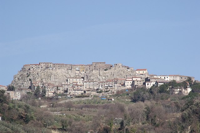
Монтичано (Monticiano, Monticiano)
.svg)
- коммуна Италии
 Hiking in Монтичано
Monticiano, a charming commune in the province of Siena, Tuscany, offers beautiful hiking opportunities amid stunning landscapes, historical sights, and diverse ecosystems. Here’s what you need to know about hiking in this region:
Trails and Routes
-
Local Trails: Monticiano has several marked trails suited for various skill levels, ranging from easy walks suitable for families to more challenging paths for experienced hikers. The nearby Montagnola Senese area is particularly popular, with trails that meander through dense forests and pass by ancient ruins and villages.
-
Nature Reserves: The Basso Merse Nature Reserve is in proximity, providing hiking paths that showcase diverse flora and fauna, including the Merse River, which offers opportunities for picnicking and birdwatching.
-
Historical Routes: Many hiking routes in the area lead to historical landmarks, including medieval castles and ancient churches. These trails often provide insight into the local history and culture.
Best Times to Hike
- Spring and Fall: The best times for hiking in Monticiano are spring and fall when temperatures are mild, and the scenery is particularly beautiful with blooming flowers or autumn colors.
- Summer: It can get hot during the summer months, so early morning or late afternoon hikes are advisable.
Preparation
- Footwear: Wear sturdy hiking boots with good traction as the terrain can vary from dirt paths to rocky trails.
- Water & Snacks: Always carry enough water and some snacks to keep your energy up, especially on longer hikes.
- Maps & Navigation: While trails are often marked, it's wise to have a map or a GPS device, especially if you're venturing off the beaten path.
Local Highlights
- Scenic Views: Many trails offer breathtaking views of the surrounding hills and valleys, making them perfect for photography enthusiasts.
- Wildlife Observation: Keep an eye out for local wildlife, including deer, wild boar, and various bird species.
Guided Tours
If you're new to hiking or prefer to explore with a knowledgeable guide, consider joining a local hiking tour. These guides can enhance your experience with insights into the area's natural and cultural history.
Safety Considerations
- Always inform someone about your hiking plans, especially if you’ll be hiking alone.
- Check the weather forecast and prepare accordingly.
- Be aware of the terrain and your fitness level, and choose routes that match them.
Overall, hiking in Monticiano provides a fantastic way to experience the natural beauty and rich history of Tuscany, making it a rewarding destination for outdoor enthusiasts.
- Страна:

- Почтовый код: 53015
- Телефонный код: 0577
- Код автомобильного номера: SI
- Координаты: 43° 8' 0" N, 11° 11' 0" E


- GPS треки (wikiloc): [Ссылка]
- Высота над уровнем моря: 375 м m
- Площадь: 109.5 кв.км
- Население: 1543
- Веб сайт: http://www.comune.monticiano.siena.it
- Википедия русская: wiki(ru)
- Википедия английская: wiki(en)
- Википедия национальная: wiki(it)
- Хранилище Wikidata: Wikidata: Q91272
- Катеория в википедии: [Ссылка]
- код Freebase: [/m/0dn3qq]
- код GeoNames: Альт: [6538599]
- код VIAF: Альт: [157284393]
- ID отношения в OpenStreetMap: [42323]
- код GND: Альт: [4308117-4]
- код TGN: [1045576]
- код ISTAT: 052018
- кадастровый код Италии: F676
Граничит с регионами:


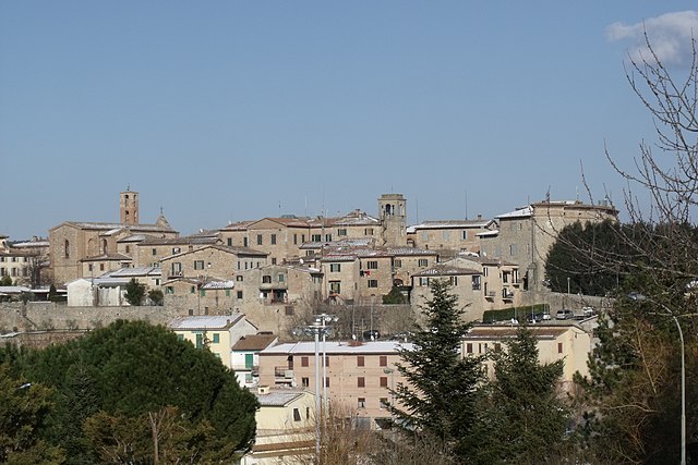
Чивителла-Паганико
- коммуна Италии
Hiking in Чивителла-Паганико
Civitella Paganico, located in the picturesque region of Tuscany, Italy, offers a range of hiking opportunities amidst rolling hills, vineyards, olive groves, and charming medieval villages. This area is characterized by its stunning landscapes and serene environment, making it a great destination for both novice and experienced hikers....
- Страна:
- Почтовый код: 58045
- Телефонный код: 0564
- Код автомобильного номера: GR
- Координаты: 42° 59' 42" N, 11° 16' 54" E
- GPS треки (wikiloc): [Ссылка]
- Высота над уровнем моря: 329 м m
- Площадь: 192.9 кв.км
- Население: 3181
- Веб сайт: [Ссылка]

Роккастрада
- коммуна Италии
Hiking in Роккастрада
Roccastrada, located in the southern part of the Tuscany region in Italy, is an excellent destination for hiking enthusiasts. The area is characterized by its beautiful landscapes, rolling hills, and rich natural and cultural heritage. Here are some highlights to consider when hiking in Roccastrada:...
- Страна:
- Почтовый код: 58036
- Телефонный код: 0564
- Код автомобильного номера: GR
- Координаты: 43° 0' 35" N, 11° 10' 6" E
- GPS треки (wikiloc): [Ссылка]
- Высота над уровнем моря: 475 м m
- Площадь: 284.47 кв.км
- Население: 9074
- Веб сайт: [Ссылка]


Кьюздино
- коммуна Италии
Hiking in Кьюздино
Chiusdino is a charming village located in the Province of Siena in Tuscany, Italy, surrounded by beautiful landscapes that make it a fantastic destination for hiking enthusiasts. The area is rich in natural beauty, history, and culture, providing a great backdrop for outdoor activities....
- Страна:
- Почтовый код: 53012
- Телефонный код: 0577
- Код автомобильного номера: SI
- Координаты: 43° 9' 17" N, 11° 5' 3" E
- GPS треки (wikiloc): [Ссылка]
- Высота над уровнем моря: 564 м m
- Площадь: 141.62 кв.км
- Население: 1877
- Веб сайт: [Ссылка]


Мурло
- коммуна Италии
Hiking in Мурло
Murlo is a small town located in the Tuscany region of Italy, known for its beautiful landscapes, rich history, and picturesque views. Hiking in and around Murlo offers a unique experience, with a mix of scenic trails, olive groves, vineyards, and ancient ruins....
- Страна:
- Почтовый код: 53016
- Телефонный код: 0577
- Код автомобильного номера: SI
- Координаты: 43° 10' 16" N, 11° 23' 32" E
- GPS треки (wikiloc): [Ссылка]
- Высота над уровнем моря: 294 м m
- Площадь: 114.61 кв.км
- Население: 2449
- Веб сайт: [Ссылка]

Совичилле
- коммуна Италии
Hiking in Совичилле
Sovicille is a charming town located in the province of Siena, Tuscany, Italy. It's surrounded by beautiful landscapes that make it an excellent destination for hiking enthusiasts. Here are some key points about hiking in and around Sovicille:...
- Страна:
- Почтовый код: 53018
- Телефонный код: 0577
- Код автомобильного номера: SI
- Координаты: 43° 17' 0" N, 11° 14' 0" E
- GPS треки (wikiloc): [Ссылка]
- Высота над уровнем моря: 265 м m
- Площадь: 144 кв.км
- Население: 10057
- Веб сайт: [Ссылка]