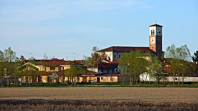
Чилавенья (Cilavegna, Cilavegna)
.svg)
- коммуна Италии
 Hiking in Чилавенья
Cilavegna is a small town in the Lombardy region of Italy, located in the province of Pavia. While it is not widely known as a major hiking destination, there are opportunities for walking and enjoying nature in the surrounding areas.
Here are a few tips and insights on hiking or walking in and around Cilavegna:
Local Nature:
-
Countryside Walks: The area around Cilavegna features flat countryside landscapes, characterized by farmland, rivers, and small woodlands. These can be explored through various rural paths.
-
Ticino Park: Not too far from Cilavegna, the Ticino Valley Natural Park offers various hiking trails and beautiful scenery. The park is known for its diverse ecosystems, including forests and riverbanks, ideal for longer hikes or leisurely nature walks.
-
Oasis of Vanzago: This nature reserve is a bit further away but is worth the visit for those looking for more structured trails and a chance to see local wildlife, including birds and other species.
Hiking Tips:
-
Trail Maps: Before heading out, it’s advisable to check local trail maps or mobile apps that can guide you through the area.
-
Footwear: Since many paths could be rural or not well maintained, wear comfortable hiking footwear to prevent slips and ensure a comfortable experience.
-
Seasonal Considerations: Spring and fall can be particularly beautiful times to hike in this region as the weather is mild and the landscape is vibrant.
-
Local Regulations: Be aware of any local guidelines or regulations regarding access to certain trails, especially in protected areas.
Recommendations:
If you’re looking for more adventurous hiking, consider traveling to the nearby hills of the Apennines or the Alps further north. They offer a wide array of trails catering to all levels of hikers, from leisurely walks to challenging hikes. Enjoy your outdoor exploration!
- Страна:

- Почтовый код: 27024
- Телефонный код: 0381
- Код автомобильного номера: PV
- Координаты: 45° 19' 0" N, 8° 45' 0" E


- GPS треки (wikiloc): [Ссылка]
- Высота над уровнем моря: 115 м m
- Площадь: 18.05 кв.км
- Население: 5548
- Веб сайт: http://www.comune.cilavegna.pv.it/
- Википедия русская: wiki(ru)
- Википедия английская: wiki(en)
- Википедия национальная: wiki(it)
- Хранилище Wikidata: Wikidata: Q39733
- Катеория в википедии: [Ссылка]
- код Freebase: [/m/0gjhr8]
- код GeoNames: Альт: [6540356]
- ID отношения в OpenStreetMap: [44658]
- WOEID: [714091]
- UN/LOCODE: [ITCIC]
- код ISTAT: 018050
- кадастровый код Италии: C686
Граничит с регионами:
Борголавеццаро
- коммуна Италии
Hiking in Борголавеццаро
Borgolavezzaro is a small village in the province of Novara, located in the Piedmont region of Italy. The area surrounding Borgolavezzaro offers a unique blend of natural beauty, scenic landscapes, and cultural experiences that can make hiking here enjoyable....
- Страна:
- Почтовый код: 28071
- Телефонный код: 0321
- Код автомобильного номера: NO
- Координаты: 45° 19' 0" N, 8° 42' 0" E
- GPS треки (wikiloc): [Ссылка]
- Высота над уровнем моря: 118 м m
- Площадь: 21.09 кв.км
- Население: 2041
- Веб сайт: [Ссылка]

Торнако
- коммуна Италии
Hiking in Торнако
Tornaco is a small municipality located in the Piedmont region of Italy. While it may not be as well-known as some of the larger cities or national parks, the surrounding area offers beautiful landscapes and opportunities for outdoor activities, including hiking....
- Страна:
- Почтовый код: 28070
- Телефонный код: 0321
- Код автомобильного номера: NO
- Координаты: 45° 21' 0" N, 8° 43' 0" E
- GPS треки (wikiloc): [Ссылка]
- Высота над уровнем моря: 122 м m
- Площадь: 13.24 кв.км
- Население: 933
- Веб сайт: [Ссылка]


Альбонезе
- коммуна Италии
Hiking in Альбонезе
It seems there may be some confusion, as "Albonese" does not appear to correspond to a known hiking location or region in the context of popular hiking destinations. However, if you meant a specific area, region, or park that is similar in name or if you could provide more context (such as country or notable features), I would be happy to help you with information on hiking opportunities there....
- Страна:
- Почтовый код: 27020
- Телефонный код: 0384
- Код автомобильного номера: PV
- Координаты: 45° 18' 0" N, 8° 42' 0" E
- GPS треки (wikiloc): [Ссылка]
- Высота над уровнем моря: 113 м m
- Площадь: 4.33 кв.км
- Население: 553
- Веб сайт: [Ссылка]


Парона
- коммуна Италии
Hiking in Парона
Hiking in Parona, a small town in the province of Pavia in Lombardy, Italy, offers a variety of picturesque routes. Nestled in a region characterized by rolling hills, vineyards, and proximity to the Po River, Parona is an excellent base for exploring the natural beauty of the area. Here are some key points to consider for hiking in and around Parona:...
- Страна:
- Почтовый код: 27020
- Телефонный код: 0384
- Код автомобильного номера: PV
- Координаты: 45° 16' 54" N, 8° 45' 2" E
- GPS треки (wikiloc): [Ссылка]
- Высота над уровнем моря: 113 м m
- Площадь: 9.3 кв.км
- Население: 1903
- Веб сайт: [Ссылка]


Гравеллона-Ломеллина
- коммуна Италии
Hiking in Гравеллона-Ломеллина
Gravellona Lomellina is a small town located in the Lombardy region of Italy, known for its agricultural landscape and serene natural surroundings. While it may not be a mainstream hiking destination, it offers some opportunities for outdoor enthusiasts looking to explore the Italian countryside....
- Страна:
- Почтовый код: 27020
- Телефонный код: 0381
- Код автомобильного номера: PV
- Координаты: 45° 20' 0" N, 8° 46' 0" E
- GPS треки (wikiloc): [Ссылка]
- Высота над уровнем моря: 118 м m
- Площадь: 20.34 кв.км
- Население: 2713
- Веб сайт: [Ссылка]


Виджевано
- коммуна Италии
Hiking in Виджевано
Vigevano, located in the Lombardy region of Italy, is primarily known for its historical architecture and cultural heritage, particularly the stunning Piazza Ducale and the Castello Sforzesco. While Vigevano itself is not predominantly a hiking destination, it is surrounded by beautiful countryside and offers opportunities for various outdoor activities, including walking and cycling....
- Страна:
- Почтовый код: 27029
- Телефонный код: 0381
- Код автомобильного номера: PV
- Координаты: 45° 19' 0" N, 8° 52' 0" E
- GPS треки (wikiloc): [Ссылка]
- Высота над уровнем моря: 116 м m
- Площадь: 82.27 кв.км
- Население: 63505
- Веб сайт: [Ссылка]