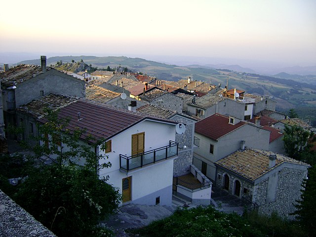
Чивиталупарелла (Civitaluparella, Civitaluparella)
.svg)
- коммуна Италии
 Hiking in Чивиталупарелла
Civitaluparella is a charming village located in the Abruzzo region of Italy, known for its stunning natural landscapes and historic architecture. It offers various hiking opportunities that cater to different skill levels, allowing hikers to explore the beautiful surroundings, including mountains, forests, and rivers.
Hiking Trails
-
Civitaluparella to the Gorges of the Rio Verde: This trail leads you through beautiful landscapes to the breathtaking gorges formed by the Rio Verde. You'll encounter lush vegetation and possibly some local wildlife.
-
Civitaluparella to Monte Genzana: For a more challenging hike, head towards Monte Genzana. This hike offers panoramic views of the surrounding mountains and valleys. The trail includes steep sections and rocky terrain, so proper footwear and preparation are essential.
-
Local Forest Paths: Explore the many less-defined trails around the village that lead you through dense forests and past serene streams. These trails are perfect for a leisurely hike and offer a chance to connect with nature.
Tips for Hiking in Civitaluparella
- Check the Weather: The weather in the Abruzzo region can change quickly, so it’s essential to check forecasts before heading out.
- Bring Proper Gear: Good hiking boots, plenty of water, snacks, and a first-aid kit are necessary. Depending on the trail, you may also want trekking poles.
- Stay on Marked Trails: To preserve the area and for your safety, stick to marked trails and do not disturb local flora or fauna.
- Respect Local Wildlife: The area is home to many species, so be mindful of your surroundings and avoid leaving litter.
Nearby Attractions
After your hike, you might want to explore the village itself, with its picturesque stone buildings and local cuisine. Enjoying some local Abruzzese dishes at a nearby trattoria can be a rewarding way to end your hiking day.
Conclusion
Civitaluparella offers a fantastic mix of nature and culture, making it an excellent destination for hikers of all levels. Whether you are looking for a leisurely walk or a challenging hike, the scenic beauty of the area is sure to leave lasting memories. Enjoy your adventure!
- Страна:

- Почтовый код: 66040
- Телефонный код: 0872
- Код автомобильного номера: CH
- Координаты: 41° 57' 0" N, 14° 18' 0" E


- GPS треки (wikiloc): [Ссылка]
- Высота над уровнем моря: 903 м m
- Площадь: 22.46 кв.км
- Население: 327
- Веб сайт: http://www.valdisangro.it/civitaluparella/
- Википедия русская: wiki(ru)
- Википедия английская: wiki(en)
- Википедия национальная: wiki(it)
- Хранилище Wikidata: Wikidata: Q51206
- Катеория в википедии: [Ссылка]
- код Freebase: [/m/0fg32r]
- код GeoNames: Альт: [6537475]
- ID отношения в OpenStreetMap: [41659]
- код ISTAT: 069023
- кадастровый код Италии: C768
Граничит с регионами:


Фалло
- коммуна Италии
Hiking in Фалло
It seems there may be a misunderstanding or a typographical error with "Fallo," as it does not refer to a well-known hiking location or area. However, if you're referring to a specific place, it could be helpful to clarify which region or country you mean....
- Страна:
- Почтовый код: 66040
- Телефонный код: 0872
- Код автомобильного номера: CH
- Координаты: 41° 56' 0" N, 14° 19' 0" E
- GPS треки (wikiloc): [Ссылка]
- Высота над уровнем моря: 575 м m
- Площадь: 6.1 кв.км
- Население: 138
- Веб сайт: [Ссылка]


Монтелапьяно
- коммуна Италии
Hiking in Монтелапьяно
Montelapiano is a charming village located in the Apennine Mountains of Italy, particularly known for its beautiful landscapes, tranquility, and opportunities for outdoor activities. Hiking in this area can be a rewarding experience for nature enthusiasts and those looking to explore the natural beauty of the region....
- Страна:
- Почтовый код: 66040
- Телефонный код: 0872
- Код автомобильного номера: CH
- Координаты: 41° 58' 0" N, 14° 21' 0" E
- GPS треки (wikiloc): [Ссылка]
- Высота над уровнем моря: 740 м m
- Площадь: 8.27 кв.км
- Население: 79
- Веб сайт: [Ссылка]
Монтебелло-суль-Сангро
- коммуна Италии
Hiking in Монтебелло-суль-Сангро
Montebello sul Sangro is a charming municipality located in the Abruzzo region of Italy, surrounded by stunning natural landscapes that are perfect for hiking enthusiasts. Here’s what you can expect when hiking in and around Montebello sul Sangro:...
- Страна:
- Почтовый код: 66040
- Телефонный код: 0872
- Код автомобильного номера: CH
- Координаты: 41° 59' 0" N, 14° 20' 0" E
- GPS треки (wikiloc): [Ссылка]
- Высота над уровнем моря: 810 м m
- Площадь: 5.38 кв.км
- Население: 88
- Веб сайт: [Ссылка]


Боррелло
- коммуна Италии
Hiking in Боррелло
Borrello is a small village located in the Abruzzo region of Italy, characterized by its beautiful landscapes, charming hillsides, and proximity to both the mountains and the Adriatic Sea. Hiking in this region can offer stunning views and a chance to explore the natural beauty of Italy....
- Страна:
- Почтовый код: 66040
- Телефонный код: 0872
- Код автомобильного номера: CH
- Координаты: 41° 55' 0" N, 14° 18' 0" E
- GPS треки (wikiloc): [Ссылка]
- Высота над уровнем моря: 804 м m
- Площадь: 14.51 кв.км
- Население: 335
- Веб сайт: [Ссылка]

Монтенеродомо
- коммуна Италии
Hiking in Монтенеродомо
Montenerodomo is a charming village located in the Abruzzo region of Italy, surrounded by stunning natural landscapes that are perfect for hiking enthusiasts. Here are some key points to consider if you're thinking about hiking in and around Montenerodomo:...
- Страна:
- Почтовый код: 66010
- Телефонный код: 0872
- Код автомобильного номера: CH
- Координаты: 41° 59' 0" N, 14° 15' 0" E
- GPS треки (wikiloc): [Ссылка]
- Высота над уровнем моря: 1165 м m
- Площадь: 30 кв.км
- Население: 656
- Веб сайт: [Ссылка]
Пеннадомо
- коммуна Италии
Hiking in Пеннадомо
Pennadomo, located in the Province of L'Aquila in the Abruzzo region of Italy, is a wonderful spot for hiking enthusiasts. The area is known for its stunning natural landscapes, including lush forests, rolling hills, and breathtaking views of the surrounding Apennine mountains....
- Страна:
- Почтовый код: 66040
- Телефонный код: 0872
- Код автомобильного номера: CH
- Координаты: 42° 0' 0" N, 14° 19' 0" E
- GPS треки (wikiloc): [Ссылка]
- Высота над уровнем моря: 460 м m
- Площадь: 11.02 кв.км
- Население: 251
- Веб сайт: [Ссылка]


Пиццоферрато
- коммуна Италии
Hiking in Пиццоферрато
Pizzoferrato, a picturesque village located in the Abruzzo region of Italy, offers a variety of hiking opportunities for outdoor enthusiasts. Nestled in the Majella National Park, the area is characterized by stunning natural landscapes, rugged mountains, and diverse flora and fauna....
- Страна:
- Почтовый код: 66040
- Телефонный код: 0872
- Код автомобильного номера: CH
- Координаты: 41° 55' 0" N, 14° 14' 0" E
- GPS треки (wikiloc): [Ссылка]
- Высота над уровнем моря: 1251 м m
- Площадь: 30.92 кв.км
- Население: 1062
- Веб сайт: [Ссылка]


Куадри
- коммуна Италии
Hiking in Куадри
Quadri is a small village located in the eastern part of the Italian Alps, specifically within the province of Cosenza in the Calabria region. While not as widely recognized as some other hiking destinations in Italy, Quadri offers beautiful natural landscapes, including mountains, forests, and scenic views....
- Страна:
- Почтовый код: 66040
- Телефонный код: 0872
- Код автомобильного номера: CH
- Координаты: 41° 55' 26" N, 14° 17' 16" E
- GPS треки (wikiloc): [Ссылка]
- Высота над уровнем моря: 590 м m
- Площадь: 7.45 кв.км
- Население: 778
- Веб сайт: [Ссылка]