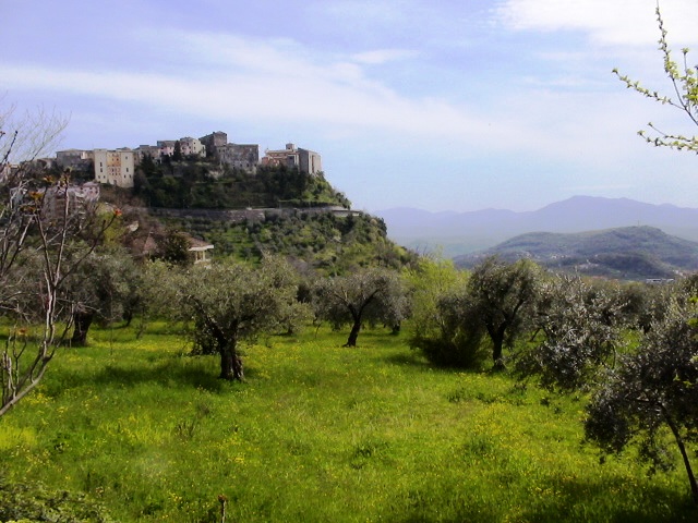
Коллепардо (Collepardo, Collepardo)
.svg)
- коммуна Италии
 Hiking in Коллепардо
Collepardo is a charming village located in the province of Frosinone, in the Lazio region of Italy. It's surrounded by beautiful landscapes, making it an excellent destination for hiking enthusiasts. Here’s what you need to know about hiking in and around Collepardo:
Trails and Routes
-
Monte Cairo: This mountain offers several trails with varying difficulty levels. The paths are well-marked, leading you through stunning landscapes that include forests, meadows, and spectacular views from the summit.
-
Caves of Collepardo: The area is known for its natural caves, such as the Grotte di Collepardo. There are hiking routes that lead you through these unique formations, combining nature walks with an element of exploration.
-
The Abbruzzo-Lazio-Molise National Park: While it’s a bit of a drive from Collepardo, this national park offers extensive hiking opportunities with a diverse range of flora and fauna. Trails vary from easy walks to challenging hikes.
Best Times to Hike
- Spring (March to May): This is perhaps the best time to hike in Collepardo, as the weather is mild, and the flora is in full bloom.
- Autumn (September to November): Another great time, with cooler temperatures and beautiful fall colors.
Essential Tips
- Footwear: Proper hiking boots are recommended, as many trails can be uneven or rocky.
- Water and Snacks: Always carry enough water and some snacks, especially if you're planning a long hike.
- Map and Guidance: While many trails are marked, having a map or a guide can enhance your experience, particularly if you wish to explore lesser-known paths.
- Weather: Always check the weather forecast before heading out, as conditions can change rapidly in the mountains.
Local Attractions
- After a day of hiking, take the time to explore Collepardo’s charming village, enjoy local cuisine at one of the trattorias, and visit historical sites such as the Abbey of Trisulti.
Collepardo provides a unique blend of natural beauty and cultural heritage, making it an ideal spot for both hiking and relaxation. Enjoy your adventure!
- Страна:

- Почтовый код: 03010
- Телефонный код: 0775
- Код автомобильного номера: FR
- Координаты: 41° 46' 0" N, 13° 22' 0" E


- GPS треки (wikiloc): [Ссылка]
- Высота над уровнем моря: 586 м m
- Площадь: 24.68 кв.км
- Население: 947
- Веб сайт: http://www.collepardo.it/
- Википедия русская: wiki(ru)
- Википедия английская: wiki(en)
- Википедия национальная: wiki(it)
- Хранилище Wikidata: Wikidata: Q116746
- Галерея изображений в википедии: [Ссылка]
- Катеория в википедии: [Ссылка]
- код Freebase: [/m/0gmwv9]
- код GeoNames: Альт: [6536982]
- код VIAF: Альт: [234367367]
- ID отношения в OpenStreetMap: [41533]
- код TGN: [1044326]
- код ISTAT: 060028
- кадастровый код Италии: C864
Граничит с регионами:


Вико-нель-Лацио
- коммуна Италии
Hiking in Вико-нель-Лацио
Vico nel Lazio is a charming town located in the province of Frosinone, in the Lazio region of Italy. It is situated in the Simbruini Mountains, which makes it an excellent destination for hiking enthusiasts. Here are some highlights and tips for hiking in and around Vico nel Lazio:...
- Страна:
- Почтовый код: 03010
- Телефонный код: 0775
- Код автомобильного номера: FR
- Координаты: 41° 47' 0" N, 13° 21' 0" E
- GPS треки (wikiloc): [Ссылка]
- Высота над уровнем моря: 720 м m
- Площадь: 45.85 кв.км
- Население: 2199
- Веб сайт: [Ссылка]


Алатри
- коммуна Италии
Hiking in Алатри
Alatri, located in the province of Frosinone in Italy, is a charming town known for its rich history and stunning landscapes, making it a great destination for hikers. The surrounding countryside offers numerous trails that cater to various skill levels, whether you’re a beginner or an experienced hiker....
- Страна:
- Почтовый код: 03011
- Телефонный код: 0775
- Код автомобильного номера: FR
- Координаты: 41° 43' 35" N, 13° 20' 32" E
- GPS треки (wikiloc): [Ссылка]
- Высота над уровнем моря: 502 м m
- Площадь: 96.96 кв.км
- Население: 28763
- Веб сайт: [Ссылка]

Вероли
- коммуна Италии
Hiking in Вероли
Veroli, a charming town situated in the province of Frosinone in the Lazio region of Italy, offers excellent opportunities for hiking enthusiasts. Nestled in the beautiful hills of the Ciociaria area, Veroli boasts stunning landscapes, rich history, and a variety of trails suitable for different experience levels....
- Страна:
- Почтовый код: 03029
- Телефонный код: 0775
- Код автомобильного номера: FR
- Координаты: 41° 41' 0" N, 13° 25' 0" E
- GPS треки (wikiloc): [Ссылка]
- Высота над уровнем моря: 594 м m
- Площадь: 119.65 кв.км
- Население: 20414
- Веб сайт: [Ссылка]