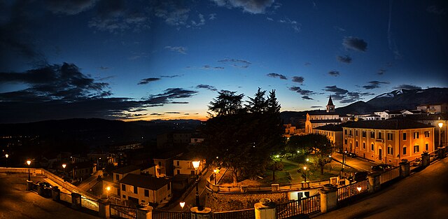
Вероли (Veroli, Veroli)
.svg)
- коммуна Италии
 Hiking in Вероли
Veroli, a charming town situated in the province of Frosinone in the Lazio region of Italy, offers excellent opportunities for hiking enthusiasts. Nestled in the beautiful hills of the Ciociaria area, Veroli boasts stunning landscapes, rich history, and a variety of trails suitable for different experience levels.
Hiking Trails in Veroli:
-
Monte Asprano:
- This mountain offers several trails, including a scenic route that takes you through lush forests and provides breathtaking views of the surrounding valleys. The hike generally takes a few hours and can be enjoyed by hikers of varying fitness levels.
-
Cicolano Valley:
- Located nearby, the Cicolano Valley features trails that meander through picturesque landscapes, with options for both short day hikes and more extended routes. The area's rich biodiversity can be appreciated along the way.
-
Ancient Pathways:
- Veroli is home to historical trails once used by pilgrims and locals. These paths connect the town to nearby villages, providing a unique blend of cultural heritage and natural beauty.
Tips for Hiking in Veroli:
-
Best Time to Hike: Spring (April to June) and autumn (September to October) are ideal for hiking, offering mild temperatures and beautiful scenery.
-
Gear: Wear sturdy hiking boots, and dress in layers to accommodate changing temperatures. Don’t forget water, snacks, and a first-aid kit.
-
Navigation: It’s helpful to have a local map or a GPS device, as some trails may not be well-marked.
-
Respect Nature: Stick to marked paths, take your litter with you, and be mindful of local wildlife.
-
Weather Check: Always check the weather forecast before heading out, as conditions can change quickly, especially in the mountains.
Cultural Aspects:
While hiking, take the time to explore the town of Veroli itself, known for its beautiful medieval architecture, including the Romanesque church of Santa Maria Salomé and the impressive Abbey of Casamari nearby. Many trails also pass through historical sites and rural landscapes, enriching your hiking experience with local culture.
Hiking in Veroli not only offers physical activity but also provides a chance to connect with nature and enjoy the tranquility of this beautiful Italian region.
- Страна:

- Почтовый код: 03029
- Телефонный код: 0775
- Код автомобильного номера: FR
- Координаты: 41° 41' 0" N, 13° 25' 0" E


- GPS треки (wikiloc): [Ссылка]
- Высота над уровнем моря: 594 м m
- Площадь: 119.65 кв.км
- Население: 20414
- Веб сайт: http://www.comune.veroli.fr.it/
- Википедия русская: wiki(ru)
- Википедия английская: wiki(en)
- Википедия национальная: wiki(it)
- Хранилище Wikidata: Wikidata: Q42466
- Галерея изображений в википедии: [Ссылка]
- Катеория в википедии: [Ссылка]
- код Freebase: [/m/0b9mfy]
- код GeoNames: Альт: [6537000]
- код BNF: [119565581]
- код VIAF: Альт: [126137506]
- ID отношения в OpenStreetMap: [41454]
- код GND: Альт: [4304663-0]
- место в MusicBrainz: [fea7161d-18b7-4ac7-9450-883e1c74cd59]
- код темы Quora: [Veroli]
- UN/LOCODE: [ITVRI]
- код в Большой каталанской энциклопедии: [0070208]
- код Цифрового атласа Римской империи: [1518]
- код Pleiades: [138648]
- код ISTAT: 060085
- кадастровый код Италии: L780
Граничит с регионами:


Бовилле-Эрника
- коммуна Италии
Hiking in Бовилле-Эрника
Boville Ernica is a charming town located in the province of Frosinone in the Lazio region of Italy. Nestled in the foothills of the Abruzzo Apennines, it offers not only historical sites but also a variety of outdoor activities, including hiking. Here are some highlights you might consider when hiking in and around Boville Ernica:...
- Страна:
- Почтовый код: 03022
- Телефонный код: 0775
- Код автомобильного номера: FR
- Координаты: 41° 38' 33" N, 13° 28' 26" E
- GPS треки (wikiloc): [Ссылка]
- Высота над уровнем моря: 450 м m
- Площадь: 28.19 кв.км
- Население: 8525
- Веб сайт: [Ссылка]

Кастеллири
- коммуна Италии
Hiking in Кастеллири
Castelliri is a small town located in the province of Frosinone in the Lazio region of Italy. Nestled in the picturesque Apennine Mountains, the area offers a variety of hiking opportunities, ranging from easy walks to more challenging trails, with stunning views of the surrounding countryside....
- Страна:
- Почтовый код: 03030
- Телефонный код: 0776
- Код автомобильного номера: FR
- Координаты: 41° 41' 0" N, 13° 33' 0" E
- GPS треки (wikiloc): [Ссылка]
- Высота над уровнем моря: 261 м m
- Площадь: 15.32 кв.км
- Население: 3411
- Веб сайт: [Ссылка]


Коллепардо
- коммуна Италии
Hiking in Коллепардо
Collepardo is a charming village located in the province of Frosinone, in the Lazio region of Italy. It's surrounded by beautiful landscapes, making it an excellent destination for hiking enthusiasts. Here’s what you need to know about hiking in and around Collepardo:...
- Страна:
- Почтовый код: 03010
- Телефонный код: 0775
- Код автомобильного номера: FR
- Координаты: 41° 46' 0" N, 13° 22' 0" E
- GPS треки (wikiloc): [Ссылка]
- Высота над уровнем моря: 586 м m
- Площадь: 24.68 кв.км
- Население: 947
- Веб сайт: [Ссылка]


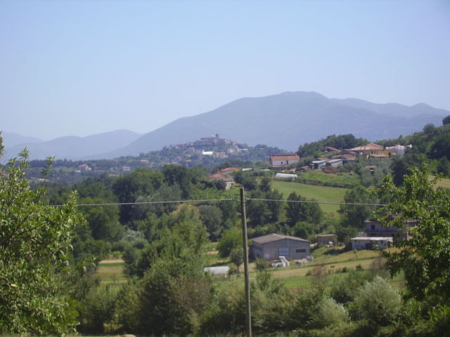
Монте-Сан-Джованни-Кампано
- коммуна Италии
Hiking in Монте-Сан-Джованни-Кампано
Monte San Giovanni Campano is a charming town located in the province of Frosinone, in the Lazio region of Italy. It is set in a picturesque landscape characterized by rolling hills, lush vegetation, and historical sites. Hiking in and around Monte San Giovanni Campano can provide an excellent opportunity for both nature lovers and those interested in exploring the historical backdrop of the region....
- Страна:
- Почтовый код: 03025
- Телефонный код: 0775
- Код автомобильного номера: FR
- Координаты: 41° 38' 0" N, 13° 31' 0" E
- GPS треки (wikiloc): [Ссылка]
- Высота над уровнем моря: 420 м m
- Площадь: 48.71 кв.км
- Население: 12706
- Веб сайт: [Ссылка]

Рипи
- коммуна Италии
Hiking in Рипи
Ripi is a small town located in the province of Frosinone in the Lazio region of Italy. While it may not be as famous for hiking as some larger areas or national parks, there are opportunities for outdoor enthusiasts to explore the beautiful landscapes and trails in and around the region....
- Страна:
- Почтовый код: 03027
- Телефонный код: 0775
- Код автомобильного номера: FR
- Координаты: 41° 37' 0" N, 13° 26' 0" E
- GPS треки (wikiloc): [Ссылка]
- Высота над уровнем моря: 300 м m
- Площадь: 31.61 кв.км
- Население: 5249
- Веб сайт: [Ссылка]

Сора
- коммуна Италии
Hiking in Сора
Sora, located in the Lazio region of Italy, is a wonderful destination for hikers and nature enthusiasts. Nestled in the Valle di Comino and surrounded by the Apennine Mountains, Sora offers various trails that cater to different skill levels, all set against stunning landscapes featuring lush forests, rivers, and picturesque views....
- Страна:
- Почтовый код: 03039
- Телефонный код: 0776
- Код автомобильного номера: FR
- Координаты: 41° 43' 0" N, 13° 37' 0" E
- GPS треки (wikiloc): [Ссылка]
- Высота над уровнем моря: 300 м m
- Площадь: 72.13 кв.км
- Население: 25972
- Веб сайт: [Ссылка]
Торриче
- коммуна Италии
Hiking in Торриче
Torrice, a charming town in Italy, may not be widely known for hiking compared to more prominent regions, but it is nestled in the beautiful province of Frosinone in Lazio, making it a great starting point for exploring the surrounding natural landscapes....
- Страна:
- Почтовый код: 03020
- Телефонный код: 0775
- Код автомобильного номера: FR
- Координаты: 41° 38' 0" N, 13° 24' 0" E
- GPS треки (wikiloc): [Ссылка]
- Высота над уровнем моря: 321 м m
- Площадь: 18.06 кв.км
- Население: 4843
- Веб сайт: [Ссылка]


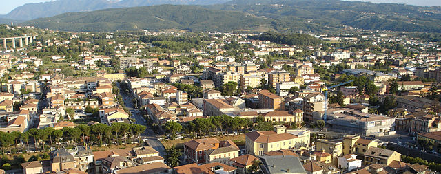
Фрозиноне
- коммуна Италии
Hiking in Фрозиноне
Frosinone, located in the Lazio region of Italy, offers a variety of hiking opportunities that cater to different skill levels and interests. The region is known for its beautiful landscapes, historical sites, and natural parks. Here are some highlights and tips for hiking in Frosinone:...
- Страна:
- Почтовый код: 03100
- Телефонный код: 0775
- Код автомобильного номера: FR
- Координаты: 41° 38' 0" N, 13° 21' 0" E
- GPS треки (wikiloc): [Ссылка]
- Высота над уровнем моря: 291 м m
- Площадь: 46.85 кв.км
- Население: 46063
- Веб сайт: [Ссылка]


Алатри
- коммуна Италии
Hiking in Алатри
Alatri, located in the province of Frosinone in Italy, is a charming town known for its rich history and stunning landscapes, making it a great destination for hikers. The surrounding countryside offers numerous trails that cater to various skill levels, whether you’re a beginner or an experienced hiker....
- Страна:
- Почтовый код: 03011
- Телефонный код: 0775
- Код автомобильного номера: FR
- Координаты: 41° 43' 35" N, 13° 20' 32" E
- GPS треки (wikiloc): [Ссылка]
- Высота над уровнем моря: 502 м m
- Площадь: 96.96 кв.км
- Население: 28763
- Веб сайт: [Ссылка]


Бальсорано
- коммуна Италии
Hiking in Бальсорано
Balsorano, located in the Abruzzo region of Italy, is a charming destination that offers a variety of hiking opportunities amid scenic landscapes. The area is characterized by its mountainous terrain, dense forests, and picturesque valleys, making it a great spot for outdoor enthusiasts....
- Страна:
- Почтовый код: 67052
- Телефонный код: 0863
- Код автомобильного номера: AQ
- Координаты: 41° 48' 35" N, 13° 33' 35" E
- GPS треки (wikiloc): [Ссылка]
- Высота над уровнем моря: 340 м m
- Площадь: 58.85 кв.км
- Население: 3455
- Веб сайт: [Ссылка]

Морино
- коммуна Италии
Hiking in Морино
Morino, located in the Aichi Prefecture of Japan, is surrounded by beautiful natural landscapes, making it a great destination for hiking enthusiasts. Here are some key points to consider if you're planning a hiking trip in Morino:...
- Страна:
- Почтовый код: 67050
- Телефонный код: 0863
- Код автомобильного номера: AQ
- Координаты: 41° 51' 55" N, 13° 27' 28" E
- GPS треки (wikiloc): [Ссылка]
- Высота над уровнем моря: 443 м m
- Площадь: 51.28 кв.км
- Население: 1417
- Веб сайт: [Ссылка]


Сан-Винченцо-Вале-Ровето
- коммуна Италии
Hiking in Сан-Винченцо-Вале-Ровето
San Vincenzo Valle Roveto, located in the Abruzzo region of Italy, is a beautiful destination for hiking enthusiasts. The area is known for its stunning landscapes, rich biodiversity, and historical significance....
- Страна:
- Почтовый код: 67050
- Телефонный код: 0863
- Код автомобильного номера: AQ
- Координаты: 41° 50' 40" N, 13° 32' 8" E
- GPS треки (wikiloc): [Ссылка]
- Высота над уровнем моря: 388 м m
- Площадь: 46.04 кв.км
- Население: 2299
- Веб сайт: [Ссылка]