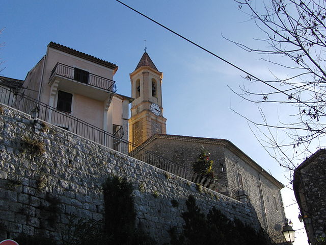
Коломар (Colomars, Colomars)
- коммуна в департаменте Приморские Альпы, регион Прованс — Альпы — Лазурный Берег, Франция
 Hiking in Коломар
Colomars is a charming commune located in the Alpes-Maritimes department in the South of France, near Nice. It’s known for its beautiful landscapes, giving hikers a variety of trails that cater to different skill levels. Here’s an overview of what you can expect when hiking in Colomars:
Scenic Trails
- Variety of Terrain: The area offers a mix of terrain, including wooded areas, rocky paths, and stunning views of the surrounding mountains and valleys.
- Views: Many trails provide panoramic views of the Mediterranean Sea, the countryside, and nearby peaks.
- Nature: The flora and fauna in and around Colomars can be quite diverse, so hikers might see various species of wildflowers, birds, and other wildlife.
Popular Hikes
- Colline de Colomars: A moderate hike that rewards you with stunning views from the summit. It’s a great option for families and casual hikers.
- Trail to Mont Gros: This is more challenging but offers even more secluded areas and impressive vistas.
- Local Routes: There are numerous smaller trails that explore the local landscape, often leading to hidden spots and less-traveled paths.
Tips for Hiking in Colomars
- Preparation: Always check the weather forecast before heading out and ensure that you have appropriate gear, including sturdy hiking shoes, water, and snacks.
- Maps and Signage: While many trails are marked, it’s always a good idea to carry a map or GPS device to avoid getting lost.
- Respect Nature: Follow Leave No Trace principles to maintain the natural beauty of the area.
- Stay Hydrated and nourished: Especially during warmer months, make sure to bring enough water and take breaks as needed.
Accessibility
Colomars is relatively accessible from Nice, making it a great choice for a day hike or a weekend trip. You can reach trailheads via public transport or by car.
Before heading out, check local resources for any updates on trail conditions or any specific rules and regulations that may be in place, especially if you're venturing into protected areas. Happy hiking!
- Страна:

- Почтовый код: 06670
- Координаты: 43° 45' 49" N, 7° 13' 20" E


- GPS треки (wikiloc): [Ссылка]
- Площадь: 6.72 кв.км
- Население: 3377
- Википедия русская: wiki(ru)
- Википедия английская: wiki(en)
- Википедия национальная: wiki(fr)
- Хранилище Wikidata: Wikidata: Q845148
- Катеория в википедии: [Ссылка]
- код Freebase: [/m/027dzgz]
- код Freebase: [/m/027dzgz]
- код GeoNames: Альт: [6446694]
- код GeoNames: Альт: [6446694]
- номер SIREN: [210600466]
- номер SIREN: [210600466]
- код VIAF: Альт: [233857261]
- код VIAF: Альт: [233857261]
- WOEID: [586514]
- WOEID: [586514]
- код муниципалитета INSEE: 06046
- код муниципалитета INSEE: 06046
Граничит с регионами:

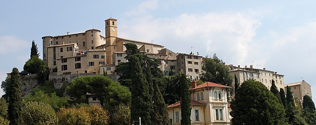
Кастанье
- коммуна в департаменте Приморские Альпы, регион Прованс — Альпы — Лазурный Берег, Франция
Hiking in Кастанье
Castagniers is a charming village located in the Alpes-Maritimes region of France, not far from Nice. It offers a mix of scenic views, cultural heritage, and well-marked hiking trails that cater to all levels of hikers....
- Страна:
- Почтовый код: 06670
- Координаты: 43° 47' 29" N, 7° 13' 54" E
- GPS треки (wikiloc): [Ссылка]
- Площадь: 7.52 кв.км
- Население: 1575
- Веб сайт: [Ссылка]

Аспремон
- коммуна в департаменте Приморские Альпы, регион Прованс — Альпы — Лазурный Берег, Франция
Hiking in Аспремон
Aspremont, located in the Alpes-Maritimes department in the Provence-Alpes-Côte d'Azur region of France, offers a variety of hiking opportunities with stunning views and a rich natural environment. Nestled in the foothills near Nice, this area provides a blend of beautiful landscape, historical sites, and a taste of local culture....
- Страна:
- Почтовый код: 06790
- Координаты: 43° 47' 0" N, 7° 14' 39" E
- GPS треки (wikiloc): [Ссылка]
- Площадь: 9.44 кв.км
- Население: 2139
- Веб сайт: [Ссылка]


Ницца
- коммуна в департаменте Приморские Альпы, регион Прованс — Альпы — Лазурный Берег, Франция
- Страна:
- Почтовый код: 06000
- Телефонный код: 493
- Координаты: 43° 42' 7" N, 7° 16' 6" E
- GPS треки (wikiloc): [Ссылка]
- Высота над уровнем моря: 10 м m
- Площадь: 71.92 кв.км
- Население: 342522
- Веб сайт: [Ссылка]

Карро
- коммуна в департаменте Приморские Альпы, регион Прованс — Альпы — Лазурный Берег, Франция
Hiking in Карро
Carros, located in the Alpes-Maritimes region of France near Nice, offers a variety of hiking opportunities that cater to all skill levels. The area is characterized by its stunning natural landscapes, including hills, forests, and panoramic views of the Mediterranean coast....
- Страна:
- Почтовый код: 06510
- Координаты: 43° 46' 21" N, 7° 11' 36" E
- GPS треки (wikiloc): [Ссылка]
- Площадь: 15.11 кв.км
- Население: 12008
- Веб сайт: [Ссылка]


Гатьер
- коммуна в департаменте Приморские Альпы, регион Прованс — Альпы — Лазурный Берег, Франция
Hiking in Гатьер
Gattières is a charming village located in the Alpes-Maritimes department in the Provence-Alpes-Côte d'Azur region of France, not far from Nice. The area surrounding Gattières offers a range of hiking opportunities that showcase the stunning landscapes of the French Riviera and the picturesque foothills of the Alps....
- Страна:
- Почтовый код: 06510
- Координаты: 43° 45' 34" N, 7° 10' 33" E
- GPS треки (wikiloc): [Ссылка]
- Площадь: 10.03 кв.км
- Население: 4111
- Веб сайт: [Ссылка]