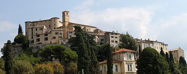
Гатьер (Gattières, Gattières)

- коммуна в департаменте Приморские Альпы, регион Прованс — Альпы — Лазурный Берег, Франция
 Hiking in Гатьер
Gattières is a charming village located in the Alpes-Maritimes department in the Provence-Alpes-Côte d'Azur region of France, not far from Nice. The area surrounding Gattières offers a range of hiking opportunities that showcase the stunning landscapes of the French Riviera and the picturesque foothills of the Alps.
Hiking Trails and Areas
-
Sentier de la Crête: This is a popular hiking trail that provides breathtaking panoramic views of the region. The terrain varies, offering both challenges and easier stretches, making it suitable for various skill levels.
-
Gorges du Loup: A short drive from Gattières, this area offers spectacular hiking opportunities along the Gorges du Loup river. The trails vary from easy walks to more difficult hikes that lead to waterfalls and scenic viewpoints.
-
Mont Chauve: Accessible from Gattières, Mont Chauve is a fantastic place to hike. The trail leads you through beautiful landscapes and offers views of the Mediterranean on clear days.
-
Local Nature Reserves: Explore nearby nature reserves such as the Parc Naturel Départemental de la Grande Corniche. These parks offer well-marked trails and a chance to see local flora and fauna.
Tips for Hiking in Gattières
- Preparation: Always check the weather before heading out, as conditions can change rapidly in the mountains.
- Footwear: Wear sturdy hiking boots for better traction and support on uneven terrain.
- Hydration and Snacks: Bring enough water and some snacks to keep your energy levels up during the hike.
- Navigation: It’s advisable to have a map or a hiking app, as some trails may not be well-marked.
- Respect Nature: Follow Leave No Trace principles to keep the environment pristine.
Best Time to Hike
The hiking season in Gattières typically runs from spring to early autumn. Late spring (May to June) and early autumn (September to October) are especially pleasant as the temperatures are milder, and the landscapes are vibrant.
Local Attractions
In addition to hiking, Gattières itself has lovely streets to explore, local shops, and little cafés where you can enjoy regional cuisine after your outdoor adventure.
Enjoy your hiking experience in Gattières! Always prioritize safety and respect the natural environment during your adventures.
- Страна:

- Почтовый код: 06510
- Координаты: 43° 45' 34" N, 7° 10' 33" E


- GPS треки (wikiloc): [Ссылка]
- Площадь: 10.03 кв.км
- Население: 4111
- Веб сайт: http://www.gattieres.fr
- Википедия русская: wiki(ru)
- Википедия английская: wiki(en)
- Википедия национальная: wiki(fr)
- Хранилище Wikidata: Wikidata: Q652150
- Катеория в википедии: [Ссылка]
- код Freebase: [/m/03m4_2t]
- код Freebase: [/m/03m4_2t]
- код Freebase: [/m/03m4_2t]
- код GeoNames: Альт: [6446708]
- код GeoNames: Альт: [6446708]
- код GeoNames: Альт: [6446708]
- номер SIREN: [210600649]
- номер SIREN: [210600649]
- номер SIREN: [210600649]
- код муниципалитета INSEE: 06064
- код муниципалитета INSEE: 06064
- код муниципалитета INSEE: 06064
Граничит с регионами:


Ницца
- коммуна в департаменте Приморские Альпы, регион Прованс — Альпы — Лазурный Берег, Франция
- Страна:
- Почтовый код: 06000
- Телефонный код: 493
- Координаты: 43° 42' 7" N, 7° 16' 6" E
- GPS треки (wikiloc): [Ссылка]
- Высота над уровнем моря: 10 м m
- Площадь: 71.92 кв.км
- Население: 342522
- Веб сайт: [Ссылка]

Сен-Жанне
- коммуна в департаменте Приморские Альпы, регион Прованс — Альпы — Лазурный Берег, Франция
Hiking in Сен-Жанне
Saint-Jeannet, located in the Alpes-Maritimes region of France, is a charming village that offers a variety of excellent hiking opportunities. Nestled in the foothills of the French Alps, it provides stunning views, diverse terrain, and a rich natural environment that attracts outdoor enthusiasts....
- Страна:
- Почтовый код: 06640
- Координаты: 43° 44' 47" N, 7° 8' 36" E
- GPS треки (wikiloc): [Ссылка]
- Площадь: 14.58 кв.км
- Население: 4071

Карро
- коммуна в департаменте Приморские Альпы, регион Прованс — Альпы — Лазурный Берег, Франция
Hiking in Карро
Carros, located in the Alpes-Maritimes region of France near Nice, offers a variety of hiking opportunities that cater to all skill levels. The area is characterized by its stunning natural landscapes, including hills, forests, and panoramic views of the Mediterranean coast....
- Страна:
- Почтовый код: 06510
- Координаты: 43° 46' 21" N, 7° 11' 36" E
- GPS треки (wikiloc): [Ссылка]
- Площадь: 15.11 кв.км
- Население: 12008
- Веб сайт: [Ссылка]


Ле-Брок
- коммуна в департаменте Приморские Альпы, регион Прованс — Альпы — Лазурный Берег, Франция
Hiking in Ле-Брок
Le Broc, located in the Alpes-Maritimes region of France, is a charming village that offers a variety of hiking opportunities suitable for different skill levels. The area's natural beauty is characterized by its rocky landscapes, rolling hills, and stunning views of the surrounding mountains and valleys....
- Страна:
- Почтовый код: 06510
- Координаты: 43° 48' 34" N, 7° 10' 12" E
- GPS треки (wikiloc): [Ссылка]
- Площадь: 18.65 кв.км
- Население: 1401
- Веб сайт: [Ссылка]


Безодён-лез-Альп
- коммуна в департаменте Приморские Альпы, регион Прованс — Альпы — Лазурный Берег, Франция
Hiking in Безодён-лез-Альп
Bézaudun-les-Alpes is a charming commune located in the Alpes-Maritimes department in southeastern France. The area is known for its stunning natural landscapes, historical architecture, and a variety of hiking opportunities that cater to different experience levels. Here are some highlights and tips for hiking in and around Bézaudun-les-Alpes:...
- Страна:
- Почтовый код: 06510
- Координаты: 43° 48' 27" N, 7° 5' 46" E
- GPS треки (wikiloc): [Ссылка]
- Площадь: 21.44 кв.км
- Население: 243
- Веб сайт: [Ссылка]

Коломар
- коммуна в департаменте Приморские Альпы, регион Прованс — Альпы — Лазурный Берег, Франция
Hiking in Коломар
Colomars is a charming commune located in the Alpes-Maritimes department in the South of France, near Nice. It’s known for its beautiful landscapes, giving hikers a variety of trails that cater to different skill levels. Here’s an overview of what you can expect when hiking in Colomars:...
- Страна:
- Почтовый код: 06670
- Координаты: 43° 45' 49" N, 7° 13' 20" E
- GPS треки (wikiloc): [Ссылка]
- Площадь: 6.72 кв.км
- Население: 3377