Combovin (Combovin)

- коммуна во Франции
 Hiking in Combovin
Combovin is a charming village located in the Drôme department of the Auvergne-Rhône-Alpes region in southeastern France. It is known for its picturesque landscapes, making it a delightful destination for hiking enthusiasts. Here are some key points about hiking in and around Combovin:
Scenic Trails
-
Variety of Terrain: The area surrounding Combovin offers a mix of terrains, including rolling hills, vineyards, and forested paths, providing a range of hiking experiences suitable for various fitness levels.
-
Local Hiking Routes: There are multiple marked hiking trails that can guide you through the stunning landscapes, including routes that may take you to viewpoints with panoramic views of the Vercors Mountains and the Rhône Valley.
-
Nature and Wildlife: As you hike, you may encounter diverse flora and fauna, including local wildlife. Keep an eye out for birds and other animals that inhabit the area.
Recommended Hikes
-
Shorter Walks: If you're looking for a leisurely stroll, many short and easy walks near the village can be enjoyed. These are perfect for families or those looking for a more relaxed experience.
-
Moderate to Challenging Hikes: For those interested in a bit more of a challenge, you can explore trails that lead into the nearby Vercors Regional Natural Park, where you will find more rugged terrain and breathtaking landscapes.
Practical Tips
-
Maps and Guides: It’s advisable to carry a detailed trail map or use a hiking app for navigation since some trails may not be well marked. The local tourist office can also provide valuable information on current trails.
-
Weather Considerations: Check the weather before heading out, as conditions can change rapidly, especially in mountainous areas. Always dress in layers and carry waterproof gear if necessary.
-
Essential Gear: Bring appropriate hiking gear including sturdy footwear, water, snacks, and first aid supplies. If you plan on spending a significant amount of time hiking, consider packing a hiking pole for added support.
-
Respect Nature: Follow Leave No Trace principles to ensure the beauty of Combovin’s landscapes remains intact for future visitors.
Whether you're an experienced hiker or just starting, Combovin offers a wonderful backdrop for exploring nature. Enjoy your hiking adventure!
- Страна:

- Почтовый код: 26120
- Координаты: 44° 52' 26" N, 5° 4' 41" E


- GPS треки (wikiloc): [Ссылка]
- Площадь: 35.86 кв.км
- Население: 405
- Википедия английская: wiki(en)
- Википедия национальная: wiki(fr)
- Хранилище Wikidata: Wikidata: Q738172
- Катеория в википедии: [Ссылка]
- код Freebase: [/m/03mhfzs]
- код GeoNames: Альт: [6430067]
- номер SIREN: [212601009]
- код BNF: [15252961d]
- код муниципалитета INSEE: 26100
Граничит с регионами:

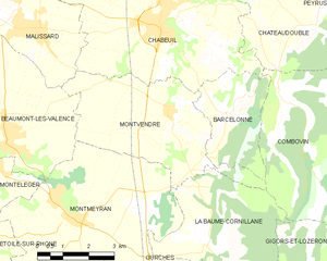
Montvendre
- коммуна во Франции
Hiking in Montvendre
Montvendre is a beautiful area located in the Auvergne-Rhône-Alpes region of France, known for its stunning landscapes, rolling hills, and diverse trails suitable for hikers of all levels. Here are some important aspects to consider when hiking in Montvendre:...
- Страна:
- Почтовый код: 26120
- Координаты: 44° 52' 18" N, 5° 1' 21" E
- GPS треки (wikiloc): [Ссылка]
- Площадь: 17.24 кв.км
- Население: 1140
- Веб сайт: [Ссылка]

Barcelonne
- коммуна во Франции
Hiking in Barcelonne
Barcelona is a fantastic city with a unique blend of urban culture and natural beauty, making it an excellent base for hiking enthusiasts. While the city itself is known for its architectural wonders, vibrant neighborhoods, and coastline, it is also surrounded by stunning natural landscapes that offer numerous hiking opportunities. Here are some key hiking spots and areas you might consider:...
- Страна:
- Почтовый код: 26120
- Координаты: 44° 52' 7" N, 5° 3' 1" E
- GPS треки (wikiloc): [Ссылка]
- Площадь: 8.28 кв.км
- Население: 350

La Baume-Cornillane
- коммуна во Франции
Hiking in La Baume-Cornillane
La Baume-Cornillane is a picturesque hiking area located near Valence in the Auvergne-Rhône-Alpes region of France. The scenery is characterized by rolling hills, forests, and diverse flora and fauna, making it an appealing destination for outdoor enthusiasts. Here are some key points to consider when hiking in La Baume-Cornillane:...
- Страна:
- Почтовый код: 26120
- Координаты: 44° 49' 25" N, 5° 2' 25" E
- GPS треки (wikiloc): [Ссылка]
- Площадь: 14.42 кв.км
- Население: 442
- Веб сайт: [Ссылка]


Le Chaffal
- коммуна во Франции
Hiking in Le Chaffal
Le Chaffal is a picturesque region located in the French Alps, known for its stunning landscapes, diverse terrain, and rich natural beauty. While it may not be as famous as some of the larger national parks or summits in the Alps, it offers a range of hiking opportunities suitable for various skill levels....
- Страна:
- Почтовый код: 26190
- Координаты: 44° 53' 13" N, 5° 10' 57" E
- GPS треки (wikiloc): [Ссылка]
- Площадь: 11.58 кв.км
- Население: 44


Châteaudouble
Hiking in Châteaudouble
Châteaudouble, located in the Drôme department of southeastern France, is an excellent destination for hiking enthusiasts. This charming village is nestled amidst stunning natural scenery, characterized by picturesque hills and sweeping valleys....
- Страна:
- Почтовый код: 26120
- Координаты: 44° 53' 59" N, 5° 5' 43" E
- GPS треки (wikiloc): [Ссылка]
- Площадь: 17.37 кв.км
- Население: 583

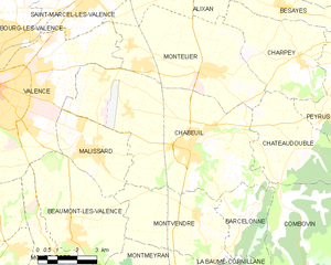
Chabeuil
- коммуна во Франции
Hiking in Chabeuil
Chabeuil is a charming commune located in the Drôme department in southeastern France, near the city of Valence. It offers a variety of hiking opportunities, showcasing the stunning landscapes of the Rhône-Alpes region. Here are some highlights about hiking in Chabeuil:...
- Страна:
- Почтовый код: 26120
- Координаты: 44° 53' 59" N, 5° 1' 12" E
- GPS треки (wikiloc): [Ссылка]
- Площадь: 41.07 кв.км
- Население: 6896
- Веб сайт: [Ссылка]


Gigors-et-Lozeron
- коммуна во Франции
Hiking in Gigors-et-Lozeron
Gigors-et-Lozeron is a beautiful commune located in the Auvergne-Rhône-Alpes region of France, nestled in the picturesque landscape of the French Alps. While it's a relatively small area, its proximity to larger mountain ranges and natural parks offers excellent hiking opportunities for outdoor enthusiasts....
- Страна:
- Почтовый код: 26400
- Координаты: 44° 47' 38" N, 5° 6' 29" E
- GPS треки (wikiloc): [Ссылка]
- Площадь: 35.27 кв.км
- Население: 163