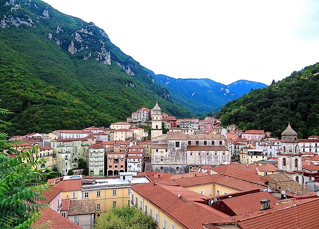
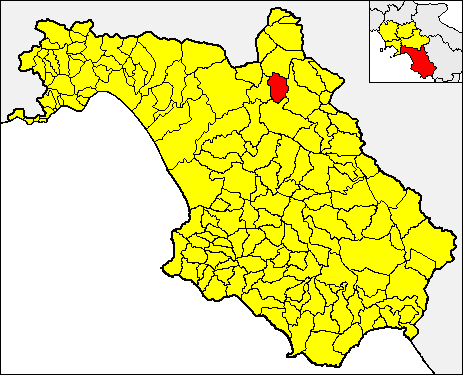
Контурси-Терме (Contursi Terme, Contursi Terme)

- коммуна Италии
 Hiking in Контурси-Терме
Contursi Terme is a picturesque town located in the Campania region of Italy, known for its thermal springs and stunning natural landscapes. Here’s a guide to hiking in and around Contursi Terme:
Recommended Hiking Trails
-
Sentiero degli Innamorati:
- This scenic trail takes you through lush greenery and offers beautiful views of the surrounding hills. It’s a relatively easy hike perfect for couples or families.
- Duration: Approximately 2-3 hours.
-
The Path of the Thermal Springs:
- This hike allows you to explore the thermal springs of Contursi Terme while enjoying the natural beauty of the area. Follow paths lined with flora and fauna while learning about the therapeutic benefits of the springs.
- Duration: 3-4 hours, depending on the chosen route.
-
Mount Marzano:
- For more experienced hikers, the ascent to Mount Marzano provides challenging terrain and rewarding panoramic views of the entire valley.
- Duration: About 5-6 hours for a round trip.
Best Times to Hike
The best times to hike in Contursi Terme are in the spring (April to June) and fall (September to October) when the weather is mild and the scenery is vibrant. Summer can be quite hot, and winter might bring some cold and wet conditions.
Preparation and Tips
- Footwear: Proper hiking boots are recommended to navigate the varied terrain.
- Hydration: Always carry water, especially for longer hikes.
- Map and GPS: It's helpful to have a map or a GPS device, as some trails can be less marked.
- Local Guides: Consider hiring a local guide who knows the trails and can provide insights into the flora, fauna, and history of the area.
Attractions
In addition to hiking, you can explore the local thermal baths for relaxation after a day on the trails. The town itself has charming architecture and several local eateries where you can enjoy traditional Campanian cuisine.
Overall, hiking in Contursi Terme offers a combination of natural beauty, cultural experiences, and relaxation, making it a wonderful destination for outdoor enthusiasts.
- Страна:

- Почтовый код: 84024
- Телефонный код: 0828
- Код автомобильного номера: SA
- Координаты: 40° 38' 0" N, 15° 14' 0" E


- GPS треки (wikiloc): [Ссылка]
- Высота над уровнем моря: 250 м m
- Площадь: 28.93 кв.км
- Население: 3332
- Веб сайт: http://www.comune.contursiterme.sa.it
- Википедия русская: wiki(ru)
- Википедия английская: wiki(en)
- Википедия национальная: wiki(it)
- Хранилище Wikidata: Wikidata: Q80887
- Катеория в википедии: [Ссылка]
- код GeoNames: Альт: [6542247]
- код VIAF: Альт: [237032248]
- ID отношения в OpenStreetMap: [40650]
- место в MusicBrainz: [a4eccde0-0b1d-4c54-a7fc-eeecee1565ed]
- UN/LOCODE: [ITCUT]
- код ISTAT: 065046
- кадастровый код Италии: C974
Граничит с регионами:

Кампанья
- коммуна Италии
Hiking in Кампанья
Campagna is a term that often refers to various rural or countryside areas in different regions, particularly in Italy. The hiking opportunities can vary widely depending on the specific location, but many areas referred to as "Campagna" offer beautiful landscapes, rolling hills, rural scenery, and opportunities to explore nature....
- Страна:
- Почтовый код: 84022; 84022–84020
- Телефонный код: 0828
- Код автомобильного номера: SA
- Координаты: 40° 40' 0" N, 15° 6' 23" E
- GPS треки (wikiloc): [Ссылка]
- Высота над уровнем моря: 270 м m
- Площадь: 136.31 кв.км
- Население: 17169
- Веб сайт: [Ссылка]


Коллиано
- коммуна Италии
Hiking in Коллиано
Colliano, a charming town located in the province of Salerno in the Campania region of southern Italy, offers a variety of hiking opportunities for outdoor enthusiasts. The region is characterized by its scenic landscapes, rich biodiversity, and historical sites, making it an enjoyable destination for hikers of all skill levels....
- Страна:
- Почтовый код: 84020
- Телефонный код: 0828
- Код автомобильного номера: SA
- Координаты: 40° 44' 0" N, 15° 17' 0" E
- GPS треки (wikiloc): [Ссылка]
- Высота над уровнем моря: 630 м m
- Площадь: 55.16 кв.км
- Население: 3590
- Веб сайт: [Ссылка]


Ольвето-Читра
- коммуна Италии
Hiking in Ольвето-Читра
Oliveto Citra is a charming town located in the Campania region of Italy, surrounded by beautiful natural landscapes that make it an excellent destination for hiking enthusiasts. The area offers a variety of trails suitable for different skill levels, from gentle walks to more challenging hikes....
- Страна:
- Почтовый код: 84020
- Телефонный код: 0828
- Код автомобильного номера: SA
- Координаты: 40° 41' 22" N, 15° 13' 52" E
- GPS треки (wikiloc): [Ссылка]
- Высота над уровнем моря: 300 м m
- Площадь: 31.62 кв.км
- Население: 3739
- Веб сайт: [Ссылка]

Паломонте
- коммуна Италии
Hiking in Паломонте
Palomonte, a charming town in the Campania region of Italy, offers various hiking opportunities, particularly for those who enjoy exploring the natural beauty and rural landscapes of the area. Here are some highlights about hiking in and around Palomonte:...
- Страна:
- Почтовый код: 84020
- Телефонный код: 0828
- Код автомобильного номера: SA
- Координаты: 40° 40' 0" N, 15° 18' 0" E
- GPS треки (wikiloc): [Ссылка]
- Высота над уровнем моря: 550 м m
- Площадь: 28 кв.км
- Население: 4103
- Веб сайт: [Ссылка]


Постильоне
- коммуна Италии
Hiking in Постильоне
Postiglione is a municipality located in the Province of Salerno, Italy, nestled in the picturesque region of Campania. Known for its charming landscapes and rural settings, Postiglione offers various hiking opportunities that cater to different skill levels....
- Страна:
- Почтовый код: 84026
- Телефонный код: 0828
- Код автомобильного номера: SA
- Координаты: 40° 34' 0" N, 15° 14' 0" E
- GPS треки (wikiloc): [Ссылка]
- Высота над уровнем моря: 615 м m
- Площадь: 48.24 кв.км
- Население: 2090
- Веб сайт: [Ссылка]


Сичиньано-дегли-Альбурни
- коммуна Италии
Hiking in Сичиньано-дегли-Альбурни
Sicignano degli Alburni is a charming town located in the Campania region of southern Italy. It’s nestled in the Alburni Mountains, which offer a diverse range of hiking opportunities, rich natural beauty, and stunning landscapes. Here’s an overview of hiking in and around Sicignano degli Alburni:...
- Страна:
- Почтовый код: 84029
- Телефонный код: 0828
- Код автомобильного номера: SA
- Координаты: 40° 33' 35" N, 15° 18' 25" E
- GPS треки (wikiloc): [Ссылка]
- Высота над уровнем моря: 605 м m
- Площадь: 81.11 кв.км
- Население: 3411
- Веб сайт: [Ссылка]