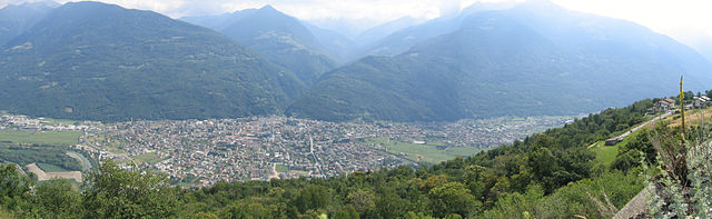
Козьо-Вальтеллино (Cosio Valtellino, Cosio Valtellino)
.svg)
- коммуна Италии
 Hiking in Козьо-Вальтеллино
Cosio Valtellino, located in the province of Sondrio in the Valtellina region of northern Italy, is a hidden gem for hikers and nature enthusiasts. This area offers a variety of trails that cater to different skill levels, showcasing stunning landscapes, rich flora and fauna, and traditional alpine culture.
Hiking Trails
-
Sentiero dei Parchi: This trail connects several parks in the region and offers a mix of walking paths through lush forests, panoramic viewpoints, and opportunities to see local wildlife.
-
Mount Olano: A moderately challenging hike that brings you to the summit of Mount Olano, offering breathtaking views of the surrounding valleys and peaks. The trail is well-marked and suitable for those with a reasonable level of fitness.
-
Val di Rezzalo: Starting from Cosio Valtellino, you can hike towards Val di Rezzalo. This valley is known for its pristine nature and tranquility, making it ideal for a day of exploration.
-
Bocca di Selva: This route is part of the ancient trails that crisscross the mountains and is perfect for both hiking and historical exploration, as you can find remnants of old pathways used by locals.
Best Time to Hike
The ideal time to hike in Cosio Valtellino is during late spring through early autumn (from May to October). During this period, the weather is typically mild, and the trails are less muddy compared to winter or early spring.
Preparation Tips
- Gear: Ensure you have appropriate hiking gear, including sturdy footwear, weather-appropriate clothing, and a backpack with essentials (water, snacks, first aid kit).
- Navigation: While many trails are well-marked, carrying a map or GPS device is advisable.
- Weather Check: Always check the local weather forecast before heading out, as conditions in the mountains can change rapidly.
Local Culture
Take some time to appreciate the local culture, including traditional Valtellinese cuisine. Sampling local cheeses, cured meats, and wines can enhance your hiking experience.
Whether you are an experienced hiker or a beginner, Cosio Valtellino has diverse options that allow you to enjoy the natural beauty and peaceful environment of this wonderful region.
- Страна:

- Почтовый код: 23013
- Телефонный код: 0342
- Код автомобильного номера: SO
- Координаты: 46° 8' 0" N, 9° 32' 0" E


- GPS треки (wikiloc): [Ссылка]
- Высота над уровнем моря: 231 м m
- Площадь: 23.99 кв.км
- Население: 5512
- Веб сайт: http://www.comune.cosiovaltellino.so.it/mainPortal/index.php?option=com_content&task=view&id=247&Itemid=318
- Википедия русская: wiki(ru)
- Википедия английская: wiki(en)
- Википедия национальная: wiki(it)
- Хранилище Wikidata: Wikidata: Q41059
- Катеория в википедии: [Ссылка]
- код Freebase: [/m/0gj2zn]
- код GeoNames: Альт: [6542760]
- код VIAF: Альт: [247418340]
- ID отношения в OpenStreetMap: [46872]
- место в MusicBrainz: [6cd8f687-ab68-4b9d-b6d5-97def999e0be]
- UN/LOCODE: [ITCVW]
- код ISTAT: 014024
- кадастровый код Италии: D088
Граничит с регионами:


Траона
- коммуна Италии
Hiking in Траона
Traona is a charming village located in the Valtellina Valley of northern Italy, and it offers some beautiful hiking opportunities that cater to various skill levels. Here are some highlights about hiking in and around Traona:...
- Страна:
- Почтовый код: 23019
- Телефонный код: 0342
- Код автомобильного номера: SO
- Координаты: 46° 9' 0" N, 9° 31' 0" E
- GPS треки (wikiloc): [Ссылка]
- Высота над уровнем моря: 252 м m
- Площадь: 6.37 кв.км
- Население: 2782
- Веб сайт: [Ссылка]
Разура
- коммуна Италии
Hiking in Разура
Rasura is a lesser-known but beautiful hiking destination located in the Lombardy region of northern Italy. It offers a unique combination of stunning landscapes, rich history, and cultural experiences. Here’s an overview of what you can expect when hiking in Rasura:...
- Страна:
- Почтовый код: 23010
- Телефонный код: 0342
- Код автомобильного номера: SO
- Координаты: 46° 6' 0" N, 9° 33' 0" E
- GPS треки (wikiloc): [Ссылка]
- Высота над уровнем моря: 762 м m
- Площадь: 6 кв.км
- Население: 291
- Веб сайт: [Ссылка]

Морбеньо
- коммуна Италии
Hiking in Морбеньо
Morbegno is a charming town in the Valtellina region of northern Italy, nestled among the Alps. It offers a variety of hiking opportunities, suitable for different skill levels, from gentle walks to more challenging treks....
- Страна:
- Почтовый код: 23017
- Телефонный код: 0342
- Код автомобильного номера: SO
- Координаты: 46° 8' 0" N, 9° 34' 0" E
- GPS треки (wikiloc): [Ссылка]
- Высота над уровнем моря: 242 м m
- Площадь: 14.82 кв.км
- Население: 12407
- Веб сайт: [Ссылка]
Мантелло
- коммуна Италии
Hiking in Мантелло
Mantello is a beautiful village located in the Valtellina region of Northern Italy, nestled in the Alps. The surrounding area offers a variety of hiking opportunities for all levels of adventurers....
- Страна:
- Почтовый код: 23016
- Телефонный код: 0342
- Код автомобильного номера: SO
- Координаты: 46° 9' 0" N, 9° 29' 0" E
- GPS треки (wikiloc): [Ссылка]
- Высота над уровнем моря: 211 м m
- Площадь: 3.78 кв.км
- Население: 765
- Веб сайт: [Ссылка]


Черчино
- коммуна Италии
Hiking in Черчино
Cercino, located in the mountainous region of northern Italy, offers a variety of hiking opportunities for outdoor enthusiasts. The area is characterized by its stunning landscapes, including lush forests, hills, and mountains, making it a great destination for both novice and experienced hikers....
- Страна:
- Почтовый код: 23016
- Телефонный код: 0342
- Код автомобильного номера: SO
- Координаты: 46° 9' 0" N, 9° 30' 0" E
- GPS треки (wikiloc): [Ссылка]
- Высота над уровнем моря: 487 м m
- Площадь: 5.69 кв.км
- Население: 760
- Веб сайт: [Ссылка]
Бема
- коммуна Италии
Hiking in Бема
Bema, located in the Lombardy region of Italy, is a beautiful destination for hiking enthusiasts. Nestled in the mountainous area of the Valtellina valley, it offers stunning views, diverse landscapes, and rich flora and fauna. Here are some highlights and tips for hiking in Bema:...
- Страна:
- Почтовый код: 23010
- Телефонный код: 0342
- Код автомобильного номера: SO
- Координаты: 46° 7' 0" N, 9° 34' 0" E
- GPS треки (wikiloc): [Ссылка]
- Высота над уровнем моря: 800 м m
- Площадь: 19.22 кв.км
- Население: 116
- Веб сайт: [Ссылка]


Роголо
- коммуна Италии
Hiking in Роголо
Hiking in Rogolo, a mountain located in the Lombardy region of northern Italy, offers stunning views and a range of trails suitable for different hiking abilities. The area is known for its beautiful landscapes, rich flora and fauna, and the nearby valleys and peaks of the Orobie Alps....
- Страна:
- Почтовый код: 23010
- Телефонный код: 0342
- Код автомобильного номера: SO
- Координаты: 46° 8' 8" N, 9° 29' 14" E
- GPS треки (wikiloc): [Ссылка]
- Высота над уровнем моря: 216 м m
- Площадь: 12.83 кв.км
- Население: 553
- Веб сайт: [Ссылка]