
Дюрнштайн (Dürnstein, Dürnstein)

- город в Австрии
 Hiking in Дюрнштайн
Dürnstein is a charming village located in the Wachau Valley of Austria, known for its picturesque landscapes, vineyards, and historical sites. Hiking in and around Dürnstein offers stunning views of the Danube River, lush hillsides, and beautiful terraced vineyards.
Hiking Trails
-
Dürnstein Castle Trail:
- This is a popular hike that leads to the ruins of Dürnstein Castle, where Richard the Lionheart was imprisoned. The trail provides breathtaking views of the Danube River and the surrounding vineyards. It's a moderate trek, generally taking about an hour to reach the castle.
-
Wachau World Heritage Trail:
- The Wachau World Heritage Trail runs through Dürnstein and extends along the beautiful Danube. It connects several significant sites and offers diverse landscapes, including vineyards, forests, and historical villages.
-
Power Trail:
- This trail features various segments with differing lengths and difficulty levels. The portions around Dürnstein provide stunning views and a chance to explore local flora and fauna. It's a great option for those looking for a more extended hiking experience.
Tips for Hiking in Dürnstein
- Best Time to Hike: Spring (April to June) and autumn (September to October) are ideal times due to mild weather and beautiful scenery.
- Footwear: Wear sturdy hiking boots for better grip and support, especially on uneven terrain.
- Hydration and Snacks: Carry enough water and snacks, as some trails may not have nearby facilities.
- Maps and Signage: Trails are generally well-marked, but carrying a map or using a hiking app can be helpful.
- Local Attractions: After your hike, consider exploring Dürnstein's charming streets, tasting local wines, or visiting the nearby monasteries and vineyards.
Safety Considerations
- Always check the weather forecast before setting off, as conditions can change quickly.
- Inform someone of your hiking plans if you are going out alone.
- Stay on marked trails to protect the local environment and ensure your safety.
Hiking in Dürnstein is a fantastic way to experience the beauty of the Wachau Valley while connecting with its rich history and natural surroundings.
- Страна:

- Почтовый код: 3601
- Телефонный код: 02711
- Код автомобильного номера: KR
- Координаты: 48° 23' 44" N, 15° 31' 13" E


- GPS треки (wikiloc): [Ссылка]
- Высота над уровнем моря: 209 м m
- Площадь: 16.81 кв.км
- Население: 864
- Веб сайт: http://www.duernstein.at
- Википедия русская: wiki(ru)
- Википедия английская: wiki(en)
- Википедия национальная: wiki(de)
- Хранилище Wikidata: Wikidata: Q668600
- Галерея изображений в википедии: [Ссылка]
- Катеория в википедии: [Ссылка]
- код Freebase: [/m/04g90g]
- код GeoNames: Альт: [7871798]
- код VIAF: Альт: [129677164]
- код GND: Альт: [4013245-6]
- идентификатор местоположения ArchINFORM: [8788]
- код LCNAF: Альт: [nr97010418]
- код австрийского муниципалитета: [31304]
Граничит с регионами:
Кремс-ан-дер-Донау
- город в Австрии
Hiking in Кремс-ан-дер-Донау
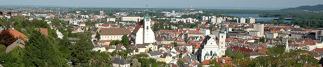
Krems an der Donau is a picturesque town in Lower Austria, situated at the confluence of the Danube River and the Krems River. It is surrounded by beautiful landscapes, vineyards, and the scenic rolling hills of the Wachau Valley, making it a great destination for hiking enthusiasts. Here are some highlights and tips for hiking in and around Krems an der Donau:...
- Страна:
- Почтовый код: 3500
- Код автомобильного номера: KS
- Координаты: 48° 25' 0" N, 15° 37' 0" E
- GPS треки (wikiloc): [Ссылка]
- Высота над уровнем моря: 203 м m
- Площадь: 51.61 кв.км
- Население: 24610
- Веб сайт: [Ссылка]

Вайнцирль-на-Вальде
Hiking in Вайнцирль-на-Вальде
Weinzierl am Walde, nestled in the picturesque region of Austria, offers a variety of hiking opportunities that cater to both beginners and experienced hikers. Here’s what you can expect when hiking in this area:...
- Страна:
- Почтовый код: 3521
- Телефонный код: 02717
- Код автомобильного номера: KR
- Координаты: 48° 25' 0" N, 15° 26' 0" E
- GPS треки (wikiloc): [Ссылка]
- Высота над уровнем моря: 647 м m
- Площадь: 44.55 кв.км
- Население: 1240
- Веб сайт: [Ссылка]

Маутерн-на-Дунае
Hiking in Маутерн-на-Дунае
Mautern an der Donau, located in Austria in the region of Lower Austria, is a charming village that offers various hiking opportunities with stunning views of the Danube River and the surrounding landscape. Here are some highlights about hiking in this area:...
- Страна:
- Почтовый код: 3512
- Телефонный код: 02732
- Код автомобильного номера: KR
- Координаты: 48° 23' 37" N, 15° 34' 39" E
- GPS треки (wikiloc): [Ссылка]
- Высота над уровнем моря: 201 м m
- Площадь: 9.14 кв.км
- Население: 3567
- Веб сайт: [Ссылка]
Вайсенкирхен-ин-дер-Вахау
Hiking in Вайсенкирхен-ин-дер-Вахау
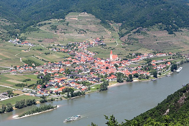
Weißenkirchen in der Wachau is a picturesque town located in the Wachau Valley region of Austria, known for its stunning landscapes, vineyards, and charming architecture. The area offers many hiking opportunities that cater to various skill levels. Here’s an overview of what you can expect when hiking in this beautiful region:...
- Страна:
- Почтовый код: 3610
- Телефонный код: 02715
- Код автомобильного номера: KR
- Координаты: 48° 23' 0" N, 15° 28' 0" E
- GPS треки (wikiloc): [Ссылка]
- Высота над уровнем моря: 224 м m
- Площадь: 23.28 кв.км
- Население: 1429
- Веб сайт: [Ссылка]
Россац-Арнсдорф
Hiking in Россац-Арнсдорф
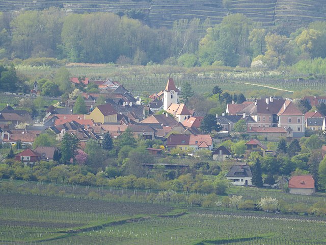
Rossatz-Arnsdorf, located in the Wachau Valley of Austria, is a picturesque area known for its stunning landscapes, vineyards, and rich cultural heritage. Hiking in this region offers a variety of trails suitable for different skill levels, making it a great destination for nature enthusiasts and outdoor adventurers....
- Страна:
- Телефонный код: 02714
- Код автомобильного номера: KR
- Координаты: 48° 23' 45" N, 15° 30' 15" E
- GPS треки (wikiloc): [Ссылка]
- Высота над уровнем моря: 225 м m
- Площадь: 3904 кв.км
- Население: 1065
- Веб сайт: [Ссылка]

Зенфтенберг
Hiking in Зенфтенберг
Senftenberg, located in the picturesque region of Lower Austria, is known for its stunning landscapes, beautiful vineyards, and scenic hiking trails. The area is part of the Wachau Valley, a UNESCO World Heritage Site, famous for its rolling hills, river views, and cultural heritage....
- Страна:
- Почтовый код: 3541
- Телефонный код: 02719
- Код автомобильного номера: KR
- Координаты: 48° 26' 0" N, 15° 33' 0" E
- GPS треки (wikiloc): [Ссылка]
- Высота над уровнем моря: 254 м m
- Площадь: 34.76 кв.км
- Население: 1977
- Веб сайт: [Ссылка]