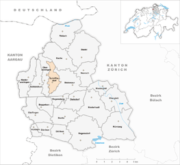
Дильсдорф (Dielsdorf district, Bezirk Dielsdorf)

 Hiking in Дильсдорф
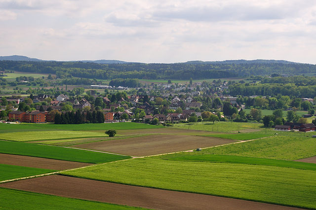
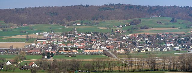
Dielsdorf District, located in the Zurich Canton of Switzerland, is a wonderful area for hiking enthusiasts. This district is characterized by a mix of beautiful landscapes, including rolling hills, lush forests, and charming villages, making it an appealing destination for both casual walkers and serious hikers.
Hiking Trails
-
Zurich Wine Trail: This trail runs through the vineyards around Dielsdorf and offers scenic views of the local countryside. It’s relatively easy and perfect for beginners or families looking for a leisurely hike.
-
Forest Trails: There are numerous well-marked forest paths in the area that provide a serene atmosphere, with opportunities to spot local wildlife and enjoy the peaceful sounds of nature.
-
High-Altitude Trails: For those looking for a moderate to challenging hike, nearby hills such as the Hörnli offer trails with stunning views of the surrounding landscape, including the Alps on clear days.
-
Historical Routes: Some trails lead past historical sites and local farms, where you can learn about the region’s heritage and perhaps even stop for some local produce or cider.
Practical Information
-
Accessibility: Dielsdorf is well-connected by public transport, making it easy to reach starting points for hiking trails. The Zurich S-Bahn network is efficient and can take you to various trailheads.
-
Facilities: Along many trails, there are picnic spots and some farms where you can purchase local foods. Bring enough water and snacks, especially if you're planning on a longer hike.
-
Seasonality: The best time for hiking is during late spring through early autumn, when the weather is pleasant and the landscapes are at their most vibrant. Snow may cover trails in winter, but snowshoeing could be an option in some areas.
Safety Tips
- Always check the weather before heading out, as conditions can change quickly in Switzerland.
- Wear appropriate footwear and clothing for the terrain and weather.
- It's advisable to carry a map or have a GPS device, as not all trails are signed equally.
- Let someone know your hiking plans, especially if you are choosing a more remote trail.
Overall, hiking in Dielsdorf District offers a wonderful way to experience the natural beauty of Switzerland while also enjoying the charm of its rural culture. Whether you’re looking for a short walk or a longer hike, there's plenty to explore!
- Страна:

- Столица: Дильсдорф
- Код автомобильного номера: ZH
- Координаты: 47° 29' 0" N, 8° 27' 0" E


- GPS треки (wikiloc): [Ссылка]
- Высота над уровнем моря: 482 м m
- Площадь: 152.73 кв.км
- Википедия русская: wiki(ru)
- Википедия английская: wiki(en)
- Википедия национальная: wiki(de)
- Хранилище Wikidata: Wikidata: Q660407
- Катеория в википедии: [Ссылка]
- код Freebase: [/m/01kk3l]
- код GeoNames: Альт: [6458865]
- идентификатор местоположения ArchINFORM: [42729]
Включает регионы:


Регенсдорф
Hiking in Регенсдорф
Regensdorf, located in the Canton of Zurich in Switzerland, is a wonderful base for hiking enthusiasts. The surrounding areas offer various trails that cater to different skills and preferences. Here are some highlights for hiking in and around Regensdorf:...
- Страна:
- Почтовый код: 8105
- Телефонный код: 044
- Код автомобильного номера: ZH
- Координаты: 47° 26' 24" N, 8° 28' 17" E
- GPS треки (wikiloc): [Ссылка]
- Высота над уровнем моря: 436 м m
- Площадь: 14.62 кв.км
- Население: 18253
- Веб сайт: [Ссылка]


Хюттикон
Hiking in Хюттикон
Hüttikon is a charming area located in Switzerland, ideal for hiking enthusiasts. Nestled in the scenic Zurich Oberland region, it offers numerous trails that showcase the beauty of the Swiss landscape, including forests, rolling hills, and breathtaking views of the surrounding mountains....
- Страна:
- Почтовый код: 8115
- Телефонный код: 044
- Код автомобильного номера: ZH
- Координаты: 47° 26' 45" N, 8° 23' 14" E
- GPS треки (wikiloc): [Ссылка]
- Высота над уровнем моря: 504 м m
- Площадь: 1.62 кв.км
- Население: 925
- Веб сайт: [Ссылка]


Отельфинген
Hiking in Отельфинген
Otelfingen, located in the canton of Zurich, Switzerland, offers a peaceful and scenic setting for hiking enthusiasts. The area is characterized by its rolling hills, vineyards, and beautiful countryside, making it an ideal spot for both casual walkers and more experienced hikers....
- Страна:
- Почтовый код: 8112
- Телефонный код: 044
- Код автомобильного номера: ZH
- Координаты: 47° 27' 39" N, 8° 23' 28" E
- GPS треки (wikiloc): [Ссылка]
- Высота над уровнем моря: 458 м m
- Площадь: 7.23 кв.км
- Население: 2831
- Веб сайт: [Ссылка]


Нидервенинген
Hiking in Нидервенинген
Niederweningen is a charming village located in the Canton of Aargau, Switzerland. Nestled in a picturesque landscape characterized by rolling hills, lush forests, and stunning views of the surrounding mountains, it offers an array of hiking opportunities for both beginners and experienced hikers. Here are some highlights of hiking in the Niederweningen area:...
- Страна:
- Почтовый код: 8166
- Телефонный код: 044
- Код автомобильного номера: ZH
- Координаты: 47° 30' 27" N, 8° 22' 44" E
- GPS треки (wikiloc): [Ссылка]
- Высота над уровнем моря: 505 м m
- Площадь: 6.88 кв.км
- Население: 3024
- Веб сайт: [Ссылка]

Делликон
Hiking in Делликон
Dällikon, a charming village located in the canton of Zurich, Switzerland, offers a variety of hiking opportunities in the surrounding area. The region is characterized by picturesque landscapes, rolling hills, and lush greenery, making it a great destination for both casual walkers and serious hikers....
- Страна:
- Почтовый код: 8108
- Телефонный код: 044
- Код автомобильного номера: ZH
- Координаты: 47° 26' 26" N, 8° 26' 20" E
- GPS треки (wikiloc): [Ссылка]
- Высота над уровнем моря: 440 м m
- Площадь: 4.49 кв.км
- Население: 4100
- Веб сайт: [Ссылка]


Нидерхасли
Hiking in Нидерхасли
Niederhasli is a picturesque village located in the canton of Zurich, Switzerland. It offers a range of hiking opportunities for both beginners and experienced hikers, amid beautiful natural scenery, including rolling hills, lush forests, and charming rural landscapes. Here are some key points about hiking in and around Niederhasli:...
- Страна:
- Почтовый код: 8155, 8156
- Телефонный код: 044
- Код автомобильного номера: ZH
- Координаты: 47° 28' 8" N, 8° 29' 25" E
- GPS треки (wikiloc): [Ссылка]
- Высота над уровнем моря: 423 м m
- Площадь: 11.24 кв.км
- Население: 9188
- Веб сайт: [Ссылка]


Боппельзен
Hiking in Боппельзен
Boppelsen is a municipality located in the Canton of Aargau in Switzerland, nestled in a picturesque region that offers some beautiful hiking opportunities. Here’s what you can expect when hiking in and around Boppelsen:...
- Страна:
- Телефонный код: 044
- Код автомобильного номера: ZH
- Координаты: 47° 28' 19" N, 8° 24' 25" E
- GPS треки (wikiloc): [Ссылка]
- Высота над уровнем моря: 554 м m
- Площадь: 3.94 кв.км
- Население: 1365
- Веб сайт: [Ссылка]


Букс
- община в Швейцарии, Цюрих, Дильсдорф
Hiking in Букс
Buchs is a charming municipality located in the Canton of Zürich, Switzerland, known for its picturesque landscapes and proximity to the Limmat River and the surrounding foothills of the Alps. Here’s an overview of what to expect when hiking in and around Buchs:...
- Страна:
- Телефонный код: 044
- Код автомобильного номера: ZH
- Координаты: 47° 27' 32" N, 8° 26' 14" E
- GPS треки (wikiloc): [Ссылка]
- Высота над уровнем моря: 454 м m
- Площадь: 5.87 кв.км
- Население: 6303
- Веб сайт: [Ссылка]


Шлайникон
Hiking in Шлайникон
Schleinikon is a small municipality in the canton of Zurich, Switzerland, known for its beautiful landscapes and scenic hiking trails. Here are some key points to consider if you're planning to hike in or around Schleinikon:...
- Страна:
- Почтовый код: 8165
- Телефонный код: 044
- Код автомобильного номера: ZH
- Координаты: 47° 29' 53" N, 8° 23' 32" E
- GPS треки (wikiloc): [Ссылка]
- Высота над уровнем моря: 470 м m
- Площадь: 5.65 кв.км
- Население: 736
- Веб сайт: [Ссылка]


Штайнмаур
Hiking in Штайнмаур
Steinmaur is a charming village in Switzerland, located in the canton of Zurich. The region surrounding Steinmaur offers a variety of hiking opportunities, showcasing the natural beauty of the Swiss landscape, including rolling hills, forests, and picturesque views....
- Страна:
- Почтовый код: 8162
- Телефонный код: 044
- Код автомобильного номера: ZH
- Координаты: 47° 29' 52" N, 8° 26' 36" E
- GPS треки (wikiloc): [Ссылка]
- Высота над уровнем моря: 456 м m
- Площадь: 9.39 кв.км
- Население: 3460
- Веб сайт: [Ссылка]


Рюмланг
Hiking in Рюмланг
Rümlang is a charming municipality located in the canton of Zurich, Switzerland. It offers a variety of outdoor activities, including hiking, thanks to its scenic landscapes and proximity to nature....
- Страна:
- Почтовый код: 8153
- Телефонный код: 044
- Код автомобильного номера: ZH
- Координаты: 47° 26' 50" N, 8° 31' 46" E
- GPS треки (wikiloc): [Ссылка]
- Высота над уровнем моря: 449 м m
- Площадь: 12.39 кв.км
- Население: 7929
- Веб сайт: [Ссылка]


Штадель-Нидерглат
Hiking in Штадель-Нидерглат
Stadel bei Niederglatt is a picturesque area in Switzerland, located near Zurich. It's an ideal spot for hiking enthusiasts looking to explore the beautiful landscapes of the region....
- Страна:
- Почтовый код: 8174
- Телефонный код: 044
- Код автомобильного номера: ZH
- Координаты: 47° 31' 46" N, 8° 27' 59" E
- GPS треки (wikiloc): [Ссылка]
- Высота над уровнем моря: 436 м m
- Площадь: 12.89 кв.км
- Население: 2271
- Веб сайт: [Ссылка]


Нидерглат
Hiking in Нидерглат
Niederglatt is a picturesque municipality located in the Canton of Zurich, Switzerland. While it might not be as widely known for hiking as some of its neighboring areas, the region offers various scenic trails and routes that are perfect for hiking enthusiasts of all skill levels....
- Страна:
- Почтовый код: 8172
- Телефонный код: 044
- Код автомобильного номера: ZH
- Координаты: 47° 29' 32" N, 8° 30' 12" E
- GPS треки (wikiloc): [Ссылка]
- Высота над уровнем моря: 411 м m
- Площадь: 3.6 кв.км
- Население: 4917
- Веб сайт: [Ссылка]


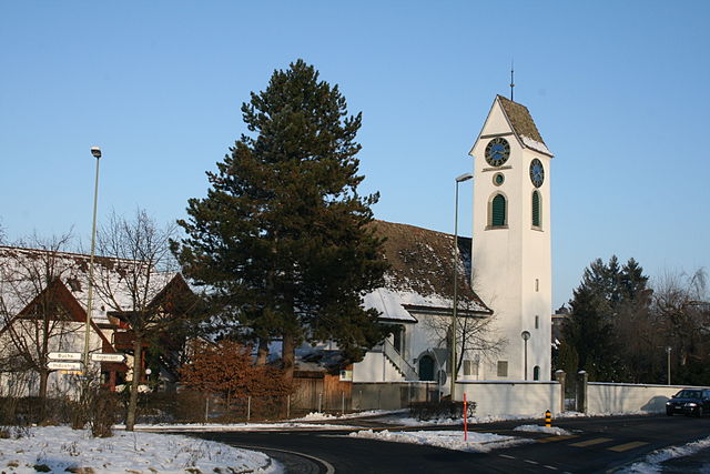
Дильсдорф
Hiking in Дильсдорф
Dielsdorf is a charming town located in the canton of Zurich, Switzerland. While it may not be as well-known for its hiking trails as some of the more mountainous regions of Switzerland, it does offer some pleasant walking and hiking opportunities, particularly for those looking to enjoy the Swiss countryside without venturing too far from urban areas....
- Страна:
- Почтовый код: 8157
- Телефонный код: 044
- Код автомобильного номера: ZH
- Координаты: 47° 29' 1" N, 8° 27' 15" E
- GPS треки (wikiloc): [Ссылка]
- Высота над уровнем моря: 455 м m
- Площадь: 5.87 кв.км
- Население: 5940
- Веб сайт: [Ссылка]


Нерах
Hiking in Нерах
Neerach, a charming village located in the Canton of Zurich, Switzerland, offers some beautiful hiking opportunities for both beginners and experienced hikers. The surrounding landscape is characterized by rolling hills, lush forests, and picturesque views, making it an excellent destination for nature enthusiasts....
- Страна:
- Почтовый код: 8173
- Телефонный код: 044
- Код автомобильного номера: ZH
- Координаты: 47° 30' 36" N, 8° 28' 31" E
- GPS треки (wikiloc): [Ссылка]
- Высота над уровнем моря: 445 м m
- Площадь: 6.04 кв.км
- Население: 3140
- Веб сайт: [Ссылка]

Оберглат
Hiking in Оберглат
Oberglatt, located in the Canton of Zurich, Switzerland, offers a variety of hiking opportunities for outdoor enthusiasts. While it may not be as well-known as some of the larger Swiss hiking areas, it provides a charming landscape characterized by gentle hills, lush forests, and picturesque rural settings. Here are some aspects to consider when hiking in Oberglatt:...
- Страна:
- Почтовый код: 8154
- Телефонный код: 044
- Код автомобильного номера: ZH
- Координаты: 47° 28' 42" N, 8° 31' 27" E
- GPS треки (wikiloc): [Ссылка]
- Высота над уровнем моря: 421 м m
- Площадь: 8.29 кв.км
- Население: 6964
- Веб сайт: [Ссылка]


Вайах
Hiking in Вайах
Weiach, a charming village located in the canton of Zurich, Switzerland, offers beautiful hiking opportunities, particularly given its access to the scenic natural landscapes along the borders with Germany. Here are some key aspects to consider for hiking in and around Weiach:...
- Страна:
- Почтовый код: 8187
- Телефонный код: 044
- Код автомобильного номера: ZH
- Координаты: 47° 33' 22" N, 8° 26' 23" E
- GPS треки (wikiloc): [Ссылка]
- Высота над уровнем моря: 391 м m
- Площадь: 9.58 кв.км
- Население: 1750
- Веб сайт: [Ссылка]


Деникон
Hiking in Деникон
Dänikon is a charming municipality located in the Canton of Zurich, Switzerland, and provides beautiful surroundings for hiking enthusiasts. The area is characterized by picturesque landscapes, rolling hills, and forests, making it an attractive destination for both casual walkers and more experienced hikers....
- Страна:
- Почтовый код: 8114
- Телефонный код: 044
- Код автомобильного номера: ZH
- Координаты: 47° 26' 41" N, 8° 24' 21" E
- GPS треки (wikiloc): [Ссылка]
- Высота над уровнем моря: 446 м m
- Площадь: 2.77 кв.км
- Население: 1869
- Веб сайт: [Ссылка]


Регенсберг
Hiking in Регенсберг
Regensberg, situated in the Zurich canton of Switzerland, is a charming area known for its scenic landscapes and historic architecture. The region offers a variety of hiking opportunities, catering to both novice and experienced hikers. Here are some highlights for hiking in Regensberg:...
- Страна:
- Почтовый код: 8158
- Телефонный код: 044
- Код автомобильного номера: ZH
- Координаты: 47° 29' 2" N, 8° 26' 19" E
- GPS треки (wikiloc): [Ссылка]
- Высота над уровнем моря: 644 м m
- Площадь: 2.37 кв.км
- Население: 473
- Веб сайт: [Ссылка]

Обервенинген
Hiking in Обервенинген
Oberweningen, located in the Canton of Zurich in Switzerland, is a charming area that offers a variety of hiking opportunities amidst beautiful landscapes. Here are some highlights and tips for hiking in and around Oberweningen:...
- Страна:
- Почтовый код: 8165
- Телефонный код: 044
- Код автомобильного номера: ZH
- Координаты: 47° 30' 32" N, 8° 24' 21" E
- GPS треки (wikiloc): [Ссылка]
- Высота над уровнем моря: 595 м m
- Площадь: 4.94 кв.км
- Население: 1797
- Веб сайт: [Ссылка]

Бакс
Hiking in Бакс
Bachs, located in Switzerland, is a picturesque region that offers beautiful hiking opportunities, often characterized by stunning alpine scenery, diverse wildlife, and charming landscapes. Whether you're a beginner or an experienced hiker, there's something for everyone....
- Страна:
- Телефонный код: 043
- Код автомобильного номера: ZH
- Координаты: 47° 31' 29" N, 8° 26' 21" E
- GPS треки (wikiloc): [Ссылка]
- Высота над уровнем моря: 470 м m
- Площадь: 9.13 кв.км
- Население: 588
- Веб сайт: [Ссылка]

Шёфлисдорф
Hiking in Шёфлисдорф
Schöfflisdorf is a charming village located in the Zurich region of Switzerland. It offers various opportunities for hiking enthusiasts to explore the beautiful Swiss countryside. Here are some highlights to consider when planning a hike in Schöfflisdorf:...
- Страна:
- Почтовый код: 8165
- Телефонный код: 044
- Код автомобильного номера: ZH
- Координаты: 47° 30' 3" N, 8° 25' 1" E
- GPS треки (wikiloc): [Ссылка]
- Высота над уровнем моря: 471 м m
- Площадь: 4.01 кв.км
- Население: 1398
- Веб сайт: [Ссылка]
Граничит с регионами:


Дитикон
Hiking in Дитикон
Hiking in the Dietikon District, located in the Canton of Zurich, Switzerland, offers a delightful blend of urban proximity and natural beauty. This area is characterized by its picturesque landscapes, rolling hills, and well-marked hiking trails that cater to various skill levels....
- Страна:
- Столица: Дитикон
- Код автомобильного номера: ZH
- Координаты: 47° 23' 0" N, 8° 25' 0" E
- GPS треки (wikiloc): [Ссылка]
- Высота над уровнем моря: 514 м m
- Площадь: 60.06 кв.км


Цюрих
- округ в Швейцарии
Hiking in Цюрих
Hiking in the Zürich District offers a wonderful blend of urban and natural experiences. The area provides a variety of trails that cater to different skill levels, from easy walks suitable for families to more challenging hikes for seasoned adventurers. Here are some popular hiking spots and trails you might consider:...
- Страна:
- Столица: Цюрих
- Код автомобильного номера: ZH
- Координаты: 47° 23' 0" N, 8° 32' 0" E
- GPS треки (wikiloc): [Ссылка]
- Высота над уровнем моря: 412 м m
- Площадь: 87.78 кв.км
- Веб сайт: [Ссылка]


Бюлах
Hiking in Бюлах
Bülach District, located in the Canton of Zurich in Switzerland, offers a variety of hiking opportunities that cater to different skill levels and preferences. The region is characterized by beautiful landscapes, cultivated fields, lush forests, and historic towns....
- Страна:
- Столица: Бюлах
- Код автомобильного номера: ZH
- Координаты: 47° 40' 0" N, 8° 34' 0" E
- GPS треки (wikiloc): [Ссылка]
- Высота над уровнем моря: 564 м m
- Площадь: 185.19 кв.км
- Население: 117000