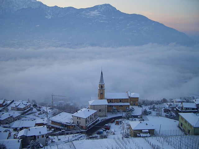
Домазо (Domaso, Domaso)
.svg)
- коммуна Италии
 Hiking in Домазо
Domaso, located on the western shore of Lake Como in Italy, is a beautiful destination for hiking enthusiasts. This charming village offers stunning views, a mild climate, and a variety of hiking trails that cater to different skill levels.
Hiking Trails in Domaso:
-
Sentiero del Viandante:
- A historic path that runs along the eastern side of Lake Como, with sections that can be accessed from Domaso. The trail offers breathtaking views of the lake and surrounding mountains. It's a moderate to challenging hike, ideal for those looking to explore the natural beauty of the area.
-
Monte Berlinghera:
- This hike takes you to the summit of Monte Berlinghera, offering panoramic views of Lake Como and the surrounding peaks. The trail is well-marked and provides a good challenge, making it suitable for intermediate hikers.
-
Valle Albano:
- A more relaxed hike through Valle Albano, which features gentle slopes and beautiful natural scenery. This trail is perfect for families and those looking for a leisurely walk in nature.
-
Trekking to Dongo:
- A scenic hike from Domaso to the nearby town of Dongo. This trail allows you to enjoy the lakeside views and explore quaint villages along the way. It’s a great option for a half-day hike.
Tips for Hiking in Domaso:
- Weather Check: Always check the weather forecast before heading out, as conditions can change rapidly in the mountains.
- Proper Gear: Wear comfortable hiking boots and bring along water, snacks, a first aid kit, and sunscreen. Depending on the season, layering is essential to adapt to changing temperatures.
- Local Signage: Follow local signage and trail markers for safety and to stay on the designated paths.
- Respect Nature: Keep to the trails to preserve the local flora and fauna and follow the Leave No Trace principles.
Conclusion:
Domaso is a fantastic base for hiking, thanks to its access to various trails with stunning views of Lake Como and the dramatic surrounding landscape. Whether you're a beginner or an experienced hiker, there’s a trail for you. Enjoy the adventure and the natural beauty that this region has to offer!
- Страна:

- Почтовый код: 22013
- Телефонный код: 0344
- Код автомобильного номера: CO
- Координаты: 46° 9' 0" N, 9° 20' 0" E


- GPS треки (wikiloc): [Ссылка]
- Высота над уровнем моря: 205 м m
- Площадь: 6.28 кв.км
- Население: 1490
- Веб сайт: http://www.comunedomaso.it
- Википедия русская: wiki(ru)
- Википедия английская: wiki(en)
- Википедия национальная: wiki(it)
- Хранилище Wikidata: Wikidata: Q47612
- Катеория в википедии: [Ссылка]
- код Freebase: [/m/0gh__g]
- код GeoNames: Альт: [6540329]
- код VIAF: Альт: [244312748]
- ID отношения в OpenStreetMap: [46934]
- UN/LOCODE: [ITDO3]
- код ISTAT: 013089
- кадастровый код Италии: D329
Граничит с регионами:


Колико
- коммуна Италии
Hiking in Колико
Colico, located on the eastern shore of Lake Como in Italy's Lombardy region, offers a wonderful mix of beautiful scenery and hiking opportunities. The region is characterized by its stunning lake views, surrounding mountains, and charming villages....
- Страна:
- Почтовый код: 23823
- Телефонный код: 0341
- Код автомобильного номера: LC
- Координаты: 46° 8' 0" N, 9° 22' 0" E
- GPS треки (wikiloc): [Ссылка]
- Высота над уровнем моря: 218 м m
- Площадь: 35.30 кв.км
- Население: 7853
- Веб сайт: [Ссылка]

Веркана
- коммуна Италии
Hiking in Веркана
Vercana is a quaint village located on the western shore of Lake Como in Italy, known for its breathtaking views and proximity to various hiking trails. The area around Vercana offers a variety of hiking opportunities for all levels, from gentle lakeside walks to more challenging mountain hikes....
- Страна:
- Почтовый код: 22013
- Телефонный код: 0344
- Код автомобильного номера: CO
- Координаты: 46° 10' 0" N, 9° 20' 0" E
- GPS треки (wikiloc): [Ссылка]
- Высота над уровнем моря: 345 м m
- Площадь: 15.01 кв.км
- Население: 758
- Веб сайт: [Ссылка]
Пельо
- коммуна в провинции Комо, Италия
Hiking in Пельо
Peglio, located in the province of Como in the Lombardy region of Italy, is a charming village surrounded by impressive natural landscapes, making it an excellent destination for hiking enthusiasts. The area is characterized by rolling hills, lush forests, and scenic views of the surrounding mountains and Lake Como....
- Страна:
- Почтовый код: 22010
- Телефонный код: 0344
- Код автомобильного номера: CO
- Координаты: 46° 9' 0" N, 9° 17' 0" E
- GPS треки (wikiloc): [Ссылка]
- Высота над уровнем моря: 650 м m
- Площадь: 10.57 кв.км
- Население: 186
- Веб сайт: [Ссылка]

Gravedona ed Uniti
- коммуна Италии
Hiking in Gravedona ed Uniti
Gravedona ed Uniti is a charming town located on the northern shores of Lake Como in Italy, known for its beautiful landscapes and rich history. Hiking in this area offers a variety of trails that cater to different skill levels, providing stunning views of the lake, surrounding mountains, and picturesque villages....
- Страна:
- Почтовый код: 22015
- Телефонный код: 0344
- Код автомобильного номера: CO
- Координаты: 46° 9' 0" N, 9° 18' 0" E
- GPS треки (wikiloc): [Ссылка]
- Высота над уровнем моря: 201 м m
- Площадь: 39.85 кв.км
- Население: 4198
- Веб сайт: [Ссылка]
Ливо
- коммуна в провинции Комо, Италия
Hiking in Ливо
Livo is a picturesque village located in the province of Sondrio in Lombardy, Italy. It is situated in the northern part of the region, close to the shores of Lake Como, and is surrounded by beautiful mountains and lush landscapes. Hiking in Livo offers various trails that cater to different skill levels, making it an excellent destination for both novice and experienced hikers....
- Страна:
- Почтовый код: 22010
- Телефонный код: 0344
- Код автомобильного номера: CO
- Координаты: 46° 10' 0" N, 9° 18' 0" E
- GPS треки (wikiloc): [Ссылка]
- Высота над уровнем моря: 675 м m
- Площадь: 33.13 кв.км
- Население: 171
- Веб сайт: [Ссылка]


Донго
- коммуна Италии
Hiking in Донго
Dongo, located in the Lombardy region of northern Italy along the shores of Lake Como, is a beautiful area for hiking and outdoor activities. Here are some key points and popular hiking opportunities in and around Dongo:...
- Страна:
- Почтовый код: 22014
- Телефонный код: 0344
- Код автомобильного номера: CO
- Координаты: 46° 7' 48" N, 9° 16' 54" E
- GPS треки (wikiloc): [Ссылка]
- Высота над уровнем моря: 208 м m
- Площадь: 7.04 кв.км
- Население: 3380
- Веб сайт: [Ссылка]