Gravedona ed Uniti (Gravedona ed Uniti)
.svg)
- коммуна Италии
 Hiking in Gravedona ed Uniti
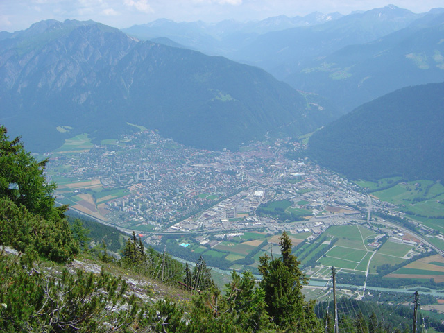
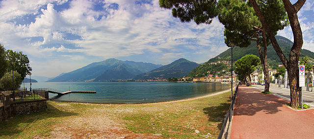
Gravedona ed Uniti is a charming town located on the northern shores of Lake Como in Italy, known for its beautiful landscapes and rich history. Hiking in this area offers a variety of trails that cater to different skill levels, providing stunning views of the lake, surrounding mountains, and picturesque villages.
Popular Hiking Trails:
-
Sentiero del Viandante:
- This is one of the most famous hiking trails in the region, stretching from Abbadia Lariana to Colico. Sections of this trail pass near Gravedona ed Uniti, offering beautiful views of Lake Como. The trail is well-marked and features both easy and moderate sections.
-
Monte Crocione:
- A more challenging hike, this trail leads to Monte Crocione, which offers panoramic views of Lake Como and the surrounding mountains. The ascent is steep, but the breathtaking vistas make the effort worthwhile.
-
Sentiero dei Fiori:
- This path connects Gravedona ed Uniti to the town of Livo. It's a picturesque trail that showcases the local flora and offers beautiful views of the lake along the way. This trail is moderately easy, making it suitable for families.
-
The Way of the Cross (Via Crucis):
- This hike consists of a series of chapels and is both spiritual and scenic. It starts from Gravedona and leads up to the Sanctuary of Sant'Anna, providing a peaceful hiking experience with lovely views.
Tips for Hiking in Gravedona ed Uniti:
- Weather: Always check the weather conditions before heading out. The best hiking months are typically from late spring to early autumn (May to October).
- Gear: Wear sturdy hiking boots, and bring appropriate clothing, water, snacks, and a first aid kit. It's advisable to have a map or a GPS app for navigation.
- Local Guidance: Consider joining a guided hike or local hiking group to learn more about the area’s history and flora/fauna.
- Cultural Exploration: Take some time to explore the town's historical sites and enjoy local cuisine after your hikes.
Hiking in Gravedona ed Uniti not only allows you to enjoy nature but also provides a unique opportunity to experience the culture and beauty of Lake Como.
- Страна:

- Почтовый код: 22015
- Телефонный код: 0344
- Код автомобильного номера: CO
- Координаты: 46° 9' 0" N, 9° 18' 0" E


- GPS треки (wikiloc): [Ссылка]
- Высота над уровнем моря: 201 м m
- Площадь: 39.85 кв.км
- Население: 4198
- Веб сайт: http://www.comune.gravedonaeduniti.co.it
- Википедия английская: wiki(en)
- Википедия национальная: wiki(it)
- Хранилище Wikidata: Wikidata: Q47459
- Катеория в википедии: [Ссылка]
Граничит с регионами:
Граубюнден
- кантон в Швейцарии
Hiking in Граубюнден
The Canton of Grisons, or Graubünden, is a breathtaking region in Switzerland known for its stunning landscapes, diverse hiking trails, and rich cultural heritage. Here are some highlights of hiking in this beautiful area:...
- Страна:

- Столица: Кур
- Код автомобильного номера: GR
- Координаты: 46° 45' 0" N, 9° 30' 0" E
- GPS треки (wikiloc): [Ссылка]
- Высота над уровнем моря: 585 м m
- Площадь: 7105.39 кв.км
- Веб сайт: [Ссылка]


Тичино
- кантон в Швейцарии
Hiking in Тичино
The Canton of Ticino, located in southern Switzerland, is a breathtaking destination for hiking enthusiasts. Known for its stunning landscapes, picturesque villages, and mild Mediterranean climate, Ticino offers a variety of trails suitable for all levels of hikers. Here are some highlights:...
- Страна:
- Столица: Кьяссо
- Телефонный код: 091
- Код автомобильного номера: TI
- Координаты: 46° 19' 0" N, 8° 49' 0" E
- GPS треки (wikiloc): [Ссылка]
- Высота над уровнем моря: 238 м m
- Площадь: 2812.15 кв.км
- Веб сайт: [Ссылка]


Колико
- коммуна Италии
Hiking in Колико
Colico, located on the eastern shore of Lake Como in Italy's Lombardy region, offers a wonderful mix of beautiful scenery and hiking opportunities. The region is characterized by its stunning lake views, surrounding mountains, and charming villages....
- Страна:
- Почтовый код: 23823
- Телефонный код: 0341
- Код автомобильного номера: LC
- Координаты: 46° 8' 0" N, 9° 22' 0" E
- GPS треки (wikiloc): [Ссылка]
- Высота над уровнем моря: 218 м m
- Площадь: 35.30 кв.км
- Население: 7853
- Веб сайт: [Ссылка]
Сан-Наццаро-Валь-Каварнья
- коммуна Италии
Hiking in Сан-Наццаро-Валь-Каварнья
San Nazzaro Val Cavargna is a picturesque village located in the province of Como, in the Lombardy region of Italy. Nestled in the Val Cavargna valley, it offers a range of excellent hiking opportunities amid stunning natural landscapes, rich flora, and charming traditional architecture....
- Страна:
- Почтовый код: 22010
- Телефонный код: 0344
- Код автомобильного номера: CO
- Координаты: 46° 5' 0" N, 9° 8' 0" E
- GPS треки (wikiloc): [Ссылка]
- Высота над уровнем моря: 995 м m
- Площадь: 12.99 кв.км
- Население: 302
- Веб сайт: [Ссылка]


Гарцено
- коммуна Италии
Hiking in Гарцено
Garzeno, located in the beautiful Valtellina region of Italy, is a lesser-known yet charming destination for hiking enthusiasts. Nestled in the Lombardy region, it offers stunning landscapes, rich flora and fauna, and a range of trails suitable for various skill levels....
- Страна:
- Почтовый код: 22010
- Телефонный код: 0344
- Код автомобильного номера: CO
- Координаты: 46° 8' 0" N, 9° 15' 0" E
- GPS треки (wikiloc): [Ссылка]
- Высота над уровнем моря: 662 м m
- Площадь: 28.76 кв.км
- Население: 754
- Веб сайт: [Ссылка]
Пельо
- коммуна в провинции Комо, Италия
Hiking in Пельо
Peglio, located in the province of Como in the Lombardy region of Italy, is a charming village surrounded by impressive natural landscapes, making it an excellent destination for hiking enthusiasts. The area is characterized by rolling hills, lush forests, and scenic views of the surrounding mountains and Lake Como....
- Страна:
- Почтовый код: 22010
- Телефонный код: 0344
- Код автомобильного номера: CO
- Координаты: 46° 9' 0" N, 9° 17' 0" E
- GPS треки (wikiloc): [Ссылка]
- Высота над уровнем моря: 650 м m
- Площадь: 10.57 кв.км
- Население: 186
- Веб сайт: [Ссылка]
Стаццона
- коммуна Италии
Hiking in Стаццона
Stazzona is a scenic area located in the Italian region of Lombardy, near the northern shores of Lake Como. Known for its stunning landscapes, charming villages, and diverse hiking trails, Stazzona offers outdoor enthusiasts a variety of options for exploration....
- Страна:
- Почтовый код: 22010
- Телефонный код: 0344
- Код автомобильного номера: CO
- Координаты: 46° 8' 20" N, 9° 16' 31" E
- GPS треки (wikiloc): [Ссылка]
- Высота над уровнем моря: 540 м m
- Площадь: 7.29 кв.км
- Население: 604
- Веб сайт: [Ссылка]


Донго
- коммуна Италии
Hiking in Донго
Dongo, located in the Lombardy region of northern Italy along the shores of Lake Como, is a beautiful area for hiking and outdoor activities. Here are some key points and popular hiking opportunities in and around Dongo:...
- Страна:
- Почтовый код: 22014
- Телефонный код: 0344
- Код автомобильного номера: CO
- Координаты: 46° 7' 48" N, 9° 16' 54" E
- GPS треки (wikiloc): [Ссылка]
- Высота над уровнем моря: 208 м m
- Площадь: 7.04 кв.км
- Население: 3380
- Веб сайт: [Ссылка]

Домазо
- коммуна Италии
Hiking in Домазо
Domaso, located on the western shore of Lake Como in Italy, is a beautiful destination for hiking enthusiasts. This charming village offers stunning views, a mild climate, and a variety of hiking trails that cater to different skill levels....
- Страна:
- Почтовый код: 22013
- Телефонный код: 0344
- Код автомобильного номера: CO
- Координаты: 46° 9' 0" N, 9° 20' 0" E
- GPS треки (wikiloc): [Ссылка]
- Высота над уровнем моря: 205 м m
- Площадь: 6.28 кв.км
- Население: 1490
- Веб сайт: [Ссылка]
Доссо-дель-Лиро
- коммуна Италии
Hiking in Доссо-дель-Лиро
Dosso del Liro is a beautiful destination for hiking enthusiasts, located in the northern part of Italy, close to the shores of Lake Como in the Lombardy region. The area is characterized by its picturesque landscapes, lush greenery, and stunning views of the surrounding mountains and valleys. Here are some key points to consider when planning a hiking trip to Dosso del Liro:...
- Страна:
- Почтовый код: 22015
- Телефонный код: 0344
- Код автомобильного номера: CO
- Координаты: 46° 10' 0" N, 9° 16' 0" E
- GPS треки (wikiloc): [Ссылка]
- Высота над уровнем моря: 650 м m
- Площадь: 23.49 кв.км
- Население: 262
- Веб сайт: [Ссылка]


Ровередо
Hiking in Ровередо
Roveredo is a quaint town located in the Mendrisiotto region of Ticino, Switzerland. Surrounded by stunning natural landscapes, it offers several hiking opportunities that cater to a variety of skill levels. Here are some highlights of hiking in Roveredo:...
- Страна:
- Почтовый код: 6535
- Телефонный код: 091
- Код автомобильного номера: GR
- Координаты: 46° 14' 5" N, 9° 7' 33" E
- GPS треки (wikiloc): [Ссылка]
- Высота над уровнем моря: 1239 м m
- Площадь: 38.79 кв.км
- Население: 2483
- Веб сайт: [Ссылка]


Сан-Витторе
Hiking in Сан-Витторе
San Vittore, located in the canton of Graubünden in Switzerland, offers a variety of hiking opportunities amidst stunning alpine scenery. Here’s an overview of what to expect when hiking in this beautiful region:...
- Страна:
- Почтовый код: 6534
- Телефонный код: 091
- Код автомобильного номера: GR
- Координаты: 46° 14' 17" N, 9° 6' 22" E
- GPS треки (wikiloc): [Ссылка]
- Высота над уровнем моря: 688 м m
- Площадь: 22.06 кв.км
- Население: 825
- Веб сайт: [Ссылка]
Sant'Antonio
Hiking in Sant'Antonio
Sant'Antonio, located near Bellinzona in the canton of Ticino, Switzerland, is a fantastic area for hiking, combining beautiful landscapes with cultural and historical elements. Here’s a guide to what you can expect when hiking in this picturesque region....
- Страна:
- Почтовый код: 6583
- Телефонный код: 091
- Код автомобильного номера: TI
- Координаты: 46° 10' 0" N, 9° 4' 0" E
- GPS треки (wikiloc): [Ссылка]
- Высота над уровнем моря: 822 м m
- Площадь: 33.57 кв.км
- Веб сайт: [Ссылка]