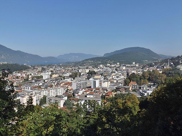
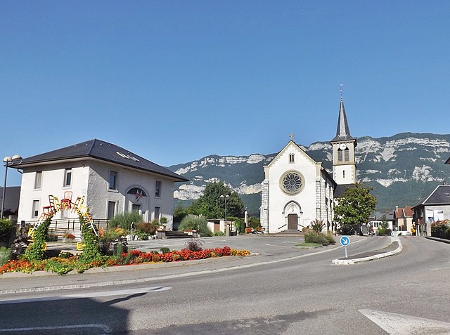
Drumettaz-Clarafond (Drumettaz-Clarafond)

- коммуна во Франции
 Hiking in Drumettaz-Clarafond
Drumettaz-Clarafond is a picturesque commune located near the shores of Lake Bourget in the Savoie region of the French Alps. It offers a variety of hiking opportunities that cater to different skill levels, making it a great destination for outdoor enthusiasts.
Hiking Trails
-
Lake Bourget Trails: The area around Lake Bourget has several scenic trails that offer beautiful lake views. The Tour du Lac is a popular walk, providing a chance to experience the serene atmosphere of the lake while enjoying views of the surrounding mountains.
-
Mont Peney: For a more challenging hike, you might consider venturing to Mont Peney. The ascent rewards hikers with stunning panoramic views of the Alps and the surrounding valleys. The trails can vary in difficulty, so it’s important to choose one that matches your skill level.
-
Nature Walks: There are also gentler paths ideal for family hikes or leisurely walks. These trails often wind through lush forests and fields, allowing hikers to immerse themselves in the natural beauty of the region.
Best Season to Hike
- Spring and Autumn: These seasons typically offer mild weather and stunning scenery, making them ideal for hiking.
- Summer: The warmer weather invites more visitors, but it’s crucial to stay hydrated and protect yourself from the sun.
- Winter: Although not traditional hiking, some trails can be explored with snowshoes or cross-country skiing, providing a completely different experience.
What to Bring
- Proper Footwear: Sturdy hiking boots are essential for rocky or uneven terrain.
- Navigation Aids: A map, compass, or GPS device is useful for less-marked trails.
- Water and Snacks: Staying hydrated and fueled is crucial, especially on longer hikes.
- Weather Gear: Be prepared for sudden changes in weather in the mountains.
Local Resources
- Visitor Centers: Utilize local tourist information centers for trail maps, tips, and updates on trail conditions.
- Guided Tours: If you're unfamiliar with the area or prefer to hike with an expert, consider joining a guided hiking tour.
Safety Precautions
- Always inform someone of your hiking plans.
- Be aware of wildlife and local regulations.
- Check the weather forecast before heading out, as conditions can change rapidly in mountainous areas.
Hiking in Drumettaz-Clarafond allows you to enjoy the stunning natural beauty of the Alps while taking in the tranquil atmosphere around Lake Bourget. Whether you're looking for a leisurely stroll or a challenging hike, this area has something for everyone. Happy hiking!
- Страна:

- Почтовый код: 73420
- Координаты: 45° 39' 32" N, 5° 56' 14" E


- GPS треки (wikiloc): [Ссылка]
- Площадь: 11.38 кв.км
- Население: 2638
- Веб сайт: http://www.drumettaz-clarafond.com
- Википедия английская: wiki(en)
- Википедия национальная: wiki(fr)
- Хранилище Wikidata: Wikidata: Q734567
- Катеория в википедии: [Ссылка]
- код Freebase: [/m/03npfyl]
- код GeoNames: Альт: [3020737]
- номер SIREN: [217301035]
- код BNF: [15274037z]
- код муниципалитета INSEE: 73103
Граничит с регионами:

Экс-ле-Бен
- коммуна во Франции
Hiking in Экс-ле-Бен
Aix-les-Bains, located in the Savoie region of France, is a beautiful town known for its thermal springs and stunning lakeside scenery. It’s an excellent base for hiking enthusiasts, offering a variety of trails set in the picturesque landscapes of the French Alps and around Lake Bourget, the largest natural lake in France....
- Страна:
- Почтовый код: 73100
- Координаты: 45° 41' 19" N, 5° 54' 54" E
- GPS треки (wikiloc): [Ссылка]
- Площадь: 12.62 кв.км
- Население: 29822
- Веб сайт: [Ссылка]
Вивье-дю-Лак
- коммуна во Франции
Hiking in Вивье-дю-Лак
Viviers-du-Lac is a charming commune located in the Savoie department of France, near the shores of Lake Bourget, the largest natural lake in France. The area offers a variety of hiking opportunities that cater to different skill levels, making it an excellent destination for outdoor enthusiasts....
- Страна:
- Почтовый код: 73420
- Координаты: 45° 38' 53" N, 5° 54' 21" E
- GPS треки (wikiloc): [Ссылка]
- Площадь: 3.94 кв.км
- Население: 2203
- Веб сайт: [Ссылка]

Méry
- коммуна во Франции
Hiking in Méry
Méry, a charming village located in the Val-d'Oise department in the Île-de-France region of France, offers some lovely hiking opportunities. The area is characterized by its picturesque landscapes, including forests, hills, and views of the surrounding countryside. Here are some points to consider if you're planning a hiking trip in Méry:...
- Страна:
- Почтовый код: 73420
- Координаты: 45° 38' 32" N, 5° 56' 19" E
- GPS треки (wikiloc): [Ссылка]
- Площадь: 9.07 кв.км
- Население: 1609
- Веб сайт: [Ссылка]


Mouxy
- коммуна во Франции
Hiking in Mouxy
Mouxy is a charming destination in the French Alps, particularly known for its proximity to Annecy and the surrounding natural beauty. Hiking enthusiasts will find a variety of trails that cater to different skill levels, offering stunning views of landscapes, lakes, and mountains....
- Страна:
- Почтовый код: 73100
- Координаты: 45° 40' 55" N, 5° 56' 4" E
- GPS треки (wikiloc): [Ссылка]
- Площадь: 6.28 кв.км
- Население: 2248
- Веб сайт: [Ссылка]


Verel-Pragondran
- коммуна во Франции
Hiking in Verel-Pragondran
Verel-Pragondran is a charming commune located in the Savoie department in the Auvergne-Rhône-Alpes region of France. It offers stunning natural landscapes perfect for hiking enthusiasts. Here are some highlights and considerations for hiking in and around Verel-Pragondran:...
- Страна:
- Почтовый код: 73230
- Координаты: 45° 36' 26" N, 5° 56' 54" E
- GPS треки (wikiloc): [Ссылка]
- Площадь: 6.53 кв.км
- Население: 457
- Веб сайт: [Ссылка]


Les Déserts
- коммуна во Франции
Hiking in Les Déserts
Les Déserts is a beautiful region in the French Alps, located near the town of Albertville in the Savoie department. This area is known for its stunning landscapes, rich flora and fauna, and several hiking trails that offer a range of difficulties for outdoor enthusiasts....
- Страна:
- Почтовый код: 73230
- Координаты: 45° 37' 17" N, 6° 0' 40" E
- GPS треки (wikiloc): [Ссылка]
- Площадь: 33.59 кв.км
- Население: 758