Эглофштайн (Egloffstein, Egloffstein)

 Hiking in Эглофштайн
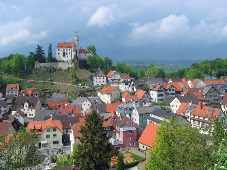
Egloffstein is a picturesque village located in the Franconian Switzerland region of Bavaria, Germany. This area is known for its stunning natural beauty, featuring rugged limestone cliffs, lush forests, and charming traditional villages. Hiking in Egloffstein is popular due to the well-maintained trails that offer a range of experiences for all hiking levels.
Hiking Trails
-
Local Trails: There are numerous local trails around Egloffstein, showcasing the stunning landscapes and unique rock formations. You can find trails that are suitable for leisurely strolls or more challenging hikes.
-
Ruins of Egloffstein Castle: A hike to the ruins of Egloffstein Castle offers not only a glimpse into the area's history but also breathtaking views over the surrounding countryside. The trail leading to the castle can vary in difficulty, but it's well worth the effort.
-
Brüttingsser Höhe: This area is known for its scenic panoramic views. Trails around this hill often lead to breathtaking viewpoints and a serene hiking experience.
-
Switzerland Route: For those seeking a longer adventure, you can join parts of the Franconian Switzerland hiking routes, which connect various towns and highlight the area's natural features.
Best Time to Hike
The best time for hiking in Egloffstein is typically from spring to autumn (April to October), when the weather is mild and the trails are dry. Autumn may offer beautiful foliage, while spring will showcase blooming wildflowers.
Tips for Hiking in Egloffstein
-
Prepare for Varying Terrain: The region has varying levels of difficulty. Make sure to wear appropriate footwear and carry enough water.
-
Check Trail Conditions: Before heading out, check local resources for trail conditions and any updates on accessibility.
-
Local Maps: Utilize local hiking maps or apps to navigate the trails and discover points of interest along the way.
-
Respect Nature: As with all outdoor activities, remember to follow Leave No Trace principles—pack out what you pack in.
With its stunning scenery and well-marked trails, Egloffstein is a fantastic destination for both novice and experienced hikers looking to explore the beauty of Franconia.
- Страна:

- Почтовый код: 91349
- Телефонный код: 09197
- Код автомобильного номера: FO
- Координаты: 49° 42' 0" N, 11° 15' 0" E


- GPS треки (wikiloc): [Ссылка]
- Высота над уровнем моря: 450 м m
- Площадь: 28.06 кв.км
- Население: 2054
- Веб сайт: http://www.egloffstein.de/
- Википедия русская: wiki(ru)
- Википедия английская: wiki(en)
- Википедия национальная: wiki(de)
- Хранилище Wikidata: Wikidata: Q503026
- Катеория в википедии: [Ссылка]
- код Freebase: [/m/02q349q]
- код GeoNames: Альт: [2932987]
- код VIAF: Альт: [239468864]
- ID отношения в OpenStreetMap: [1080516]
- код GND: Альт: [4092364-2]
- WOEID: [646738]
- код Historical Gazetteer: [EGLEI1JN59PQ]
- Bavarikon ID: [ODB_A00002035]
- идентификатор муниципалитетов в Германии: 09474124
Граничит с регионами:


Грефенберг
Hiking in Грефенберг
Gräfenberg is a charming town located in Bavaria, Germany, known for its scenic landscapes and access to various hiking trails. The region is characterized by its rolling hills, picturesque forests, and quaint villages, making it an ideal destination for hikers of all skill levels....
- Страна:
- Почтовый код: 91322
- Телефонный код: 09192
- Код автомобильного номера: FO
- Координаты: 49° 38' 40" N, 11° 14' 58" E
- GPS треки (wikiloc): [Ссылка]
- Высота над уровнем моря: 433 м m
- Площадь: 37.88 кв.км
- Население: 4071
- Веб сайт: [Ссылка]

Гёсвайнштайн
Hiking in Гёсвайнштайн
Gößweinstein is a picturesque town located in the Franconian Switzerland region of Bavaria, Germany. It's known for its beautiful landscapes, charming castles, and extensive hiking trails that cater to various skill levels....
- Страна:
- Почтовый код: 91327
- Телефонный код: 09242
- Код автомобильного номера: FO
- Координаты: 49° 46' 0" N, 11° 19' 0" E
- GPS треки (wikiloc): [Ссылка]
- Высота над уровнем моря: 443 м m
- Площадь: 57.70 кв.км
- Население: 4022
- Веб сайт: [Ссылка]


Лёйтенбах
Hiking in Лёйтенбах
Leutenbach in Bavaria is a scenic location that offers several trails for hikers of varying skill levels. Nestled within the beautiful landscapes of southern Germany, including forests, hills, and meadows, hiking here can provide a refreshing outdoor experience. Here are some highlights and tips for hiking in this area:...
- Страна:
- Почтовый код: 91359
- Телефонный код: 09199
- Код автомобильного номера: FO
- Координаты: 49° 42' 47" N, 11° 10' 20" E
- GPS треки (wikiloc): [Ссылка]
- Высота над уровнем моря: 339 м m
- Площадь: 19.46 кв.км
- Население: 1491
- Веб сайт: [Ссылка]