
Верхняя Франкония (Upper Franconia, Oberfranken)


- административный округ Баварии
 Hiking in Верхняя Франкония
Upper Franconia, located in northern Bavaria, Germany, is a lesser-known but stunning hiking destination characterized by its diverse landscapes, charming villages, and rich cultural heritage. Here are some highlights and tips for hiking in the region:
Trails and Landscapes
-
Frankenwald Nature Park:
- This area offers a wide range of trails through lush forests, rolling hills, and scenic viewpoints. The main trail, the "Frankenwaldsteig," is a long-distance hiking path that covers approximately 200 kilometers, showcasing the beauty of the region.
-
Fichtelgebirge:
- This mountain range provides various trails, from easy walks to more challenging hikes. The area is known for its granite rock formations and offers breathtaking panoramas. The "Fichtelgebirgsweg" is a popular trail that connects several key points in the region.
-
Bavarian Forest:
- A bit further afield, this region features extensive hiking options with well-marked paths. The landscape is characterized by dense woods and numerous streams, ideal for nature lovers.
-
Local Trails:
- Many towns and villages have their local hiking trails, ranging from short walks to longer routes. Look for options that lead to historical sites, like castles or ancient monasteries.
Advisable Hiking Tips
- Maps and Signage: Many trails are well-marked with signs, but it’s always a good idea to have a map or download GPS guides to ensure you stay on track.
- Weather Considerations: Be prepared for changing weather conditions, especially in mountainous areas. Dressing in layers is advisable.
- Local Cuisine: After a day of hiking, enjoy local Franconian cuisine at a nearby tavern or restaurant. Dishes often feature hearty ingredients, and you'll find excellent local beers.
- Respect Nature: Follow the ‘Leave No Trace’ principles to preserve the natural beauty of the area. Stick to paths and take any litter with you.
Cultural Experiences
- Along many hiking trails, you will find cultural landmarks such as medieval castles, traditional villages, and churches that reflect the region's history. Take time to explore and immerse yourself in the local culture.
Upper Franconia is a hidden gem for hiking enthusiasts, offering beautiful scenery, cultural experiences, and various trails suitable for all skill levels. Happy hiking!
- Страна:

- Столица: Байройт
- Координаты: 49° 57' 0" N, 11° 35' 0" E


- GPS треки (wikiloc): [Ссылка]
- Высота над уровнем моря: 368 м m
- Площадь: 7230.19 кв.км
- Население: 1062398
- Веб сайт: http://www.bezirk-oberfranken.de/
- Википедия русская: wiki(ru)
- Википедия английская: wiki(en)
- Википедия национальная: wiki(de)
- Хранилище Wikidata: Wikidata: Q10554
- Галерея изображений в википедии: [Ссылка]
- Катеория в википедии: [Ссылка]
- Карты в википедии: [Ссылка]
- код GeoNames: Альт: [2860681]
- код BNF: [12108436n]
- код VIAF: Альт: [127486552]
- ID отношения в OpenStreetMap: [17592]
- код GND: Альт: [4042917-9]
- код LCNAF: Альт: [n81143948]
- Bavarikon ID: [ODB_A00001932]
- код NUTS: [DE24]
- код региона Германии: 094
Включает регионы:

Хоф
- район Баварии
Hiking in Хоф
Hof is a district located in Bavaria, Germany, known for its scenic landscapes, charming towns, and outdoor recreational opportunities. The region offers various hiking trails that cater to different skill levels, making it a great destination for both beginners and experienced hikers....
- Страна:
- Столица: Хоф
- Код автомобильного номера: SAN; REH; NAI; MÜB; HO
- Координаты: 50° 15' 0" N, 11° 49' 48" E
- GPS треки (wikiloc): [Ссылка]
- Высота над уровнем моря: 581 м m
- Площадь: 893.00 кв.км
- Население: 105628
- Веб сайт: [Ссылка]

Вунзидель-Фихтель
- район Баварии
Hiking in Вунзидель-Фихтель
Wunsiedel is a picturesque district located in the Upper Franconia region of Bavaria, Germany. It's renowned for its beautiful landscapes, rich history, and a variety of hiking trails suitable for different skill levels. Here are some highlights of hiking in Wunsiedel:...
- Страна:
- Код автомобильного номера: SEL; REH; MAK; WUN
- Координаты: 50° 5' 24" N, 12° 2' 24" E
- GPS треки (wikiloc): [Ссылка]
- Высота над уровнем моря: 558 м m
- Площадь: 606.40 кв.км
- Население: 87941
- Веб сайт: [Ссылка]
Кронах
- район Баварии
Hiking in Кронах
Kronach, located in Bavaria, Germany, is an excellent destination for hiking enthusiasts. The district is characterized by its beautiful landscapes, rich history, and diverse trails suitable for all levels of hikers. Here are some highlights regarding hiking in Kronach:...
- Страна:
- Столица: Кронах
- Код автомобильного номера: SAN; KC
- Координаты: 50° 19' 48" N, 11° 22' 12" E
- GPS треки (wikiloc): [Ссылка]
- Высота над уровнем моря: 412 м m
- Площадь: 651.00 кв.км
- Население: 75353
- Веб сайт: [Ссылка]

Кульмбах
- район Баварии
Hiking in Кульмбах
Kulmbach district, located in Bavaria, Germany, offers a variety of hiking opportunities that showcase the region’s scenic beauty, rich history, and diverse landscapes. Here are some highlights and tips for hiking in Kulmbach:...
- Страна:
- Столица: Кульмбах
- Код автомобильного номера: SAN; KU; EBS
- Координаты: 50° 5' 12" N, 11° 23' 50" E
- GPS треки (wikiloc): [Ссылка]
- Высота над уровнем моря: 391 м m
- Площадь: 656.00 кв.км
- Население: 73055
- Веб сайт: [Ссылка]

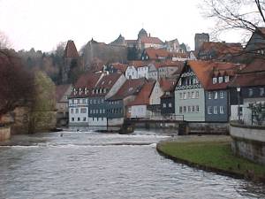
Байройт
- район Баварии
Hiking in Байройт
Bayreuth, located in the northern part of Bavaria, Germany, offers a diverse range of hiking opportunities set against a backdrop of beautiful landscapes, forests, and cultural sites. The region is known for its rich history, stunning scenery, and well-marked trails suitable for hikers of all levels....
- Страна:
- Столица: Байройт
- Код автомобильного номера: PEG; MÜB; KEM; ESB; EBS; BT
- Координаты: 49° 55' 12" N, 11° 30' 0" E
- GPS треки (wikiloc): [Ссылка]
- Высота над уровнем моря: 507 м m
- Площадь: 1273.00 кв.км
- Население: 96772
- Веб сайт: [Ссылка]
Кобург
- район в Баварии, Германия
Hiking in Кобург
Coburg district, located in Bavaria, Germany, offers a variety of hiking opportunities for outdoor enthusiasts. The region is characterized by beautiful landscapes, including rolling hills, woodlands, and scenic views that make for enjoyable hiking experiences....
- Страна:
- Столица: Кобург
- Код автомобильного номера: NEC; CO
- Координаты: 50° 16' 0" N, 10° 55' 0" E
- GPS треки (wikiloc): [Ссылка]
- Высота над уровнем моря: 306 м m
- Площадь: 592.00 кв.км
- Население: 82033
- Веб сайт: [Ссылка]

Лихтенфельс
- Район в Германии
Hiking in Лихтенфельс
Lichtenfels is a district in Bavaria, Germany, known for its picturesque landscapes and scenic hiking trails. Nestled in the heart of the Franconian region, it offers a variety of hiking opportunities suitable for different skill levels and preferences. Here are some key points about hiking in Lichtenfels:...
- Страна:
- Столица: Лихтенфельс
- Код автомобильного номера: STE; LIF
- Координаты: 50° 6' 36" N, 11° 7' 12" E
- GPS треки (wikiloc): [Ссылка]
- Высота над уровнем моря: 422 м m
- Площадь: 552.00 кв.км
- Население: 65602
- Веб сайт: [Ссылка]
Бамберг
Hiking in Бамберг
Bamberg district, located in Bavaria, Germany, offers a variety of scenic hiking opportunities amidst its charming landscapes, historical sites, and cultural attractions. Here’s an overview of what you can expect when hiking in the region:...
- Страна:
- Столица: Бамберг
- Код автомобильного номера: BA
- Координаты: 49° 49' 48" N, 10° 49' 48" E
- GPS треки (wikiloc): [Ссылка]
- Высота над уровнем моря: 275 м m
- Площадь: 1168.00 кв.км
- Население: 119829
- Веб сайт: [Ссылка]

Форххайм
Hiking in Форххайм
Forchheim, located in Bavaria, Germany, is a charming district known for its picturesque landscapes, historical sites, and access to various hiking trails. Here’s an overview of what you can expect when hiking in this region:...
- Страна:
- Код автомобильного номера: PEG; FO; EBS
- Координаты: 49° 45' 0" N, 11° 5' 0" E
- GPS треки (wikiloc): [Ссылка]
- Высота над уровнем моря: 377 м m
- Площадь: 643.00 кв.км
- Население: 97433
- Веб сайт: [Ссылка]
Кобург
- город в Баварии, Германия
Hiking in Кобург
Coburg, situated in the northern part of Bavaria, Germany, offers attractive hiking opportunities for outdoor enthusiasts. The region is characterized by its beautiful landscapes, including rolling hills, lush forests, and historic sites, making it an appealing destination for hikers of all skill levels....
- Страна:
- Почтовый код: 96450
- Телефонный код: 09561
- Код автомобильного номера: CO
- Координаты: 50° 16' 0" N, 10° 58' 0" E
- GPS треки (wikiloc): [Ссылка]
- Высота над уровнем моря: 292 м m
- Площадь: 48.30 кв.км
- Население: 40994
- Веб сайт: [Ссылка]
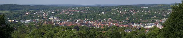
Байройт
- город в Германии
Hiking in Байройт
Bayreuth, located in Bavaria, Germany, offers a variety of hiking opportunities suitable for different skill levels, with scenic landscapes rich in history and natural beauty. Here are some highlights and recommendations for hiking in the Bayreuth area:...
- Страна:
- Почтовый код: 95401–95448
- Телефонный код: 9209; 9201; 921
- Код автомобильного номера: BT
- Координаты: 49° 56' 53" N, 11° 34' 42" E
- GPS треки (wikiloc): [Ссылка]
- Высота над уровнем моря: 344 м m
- Площадь: 66.92 кв.км
- Население: 71572
- Веб сайт: [Ссылка]
Бамберг
- город в Германии
Hiking in Бамберг
Bamberg, a charming city in Bavaria, Germany, is known for its historic architecture, beautiful landscapes, and vibrant culture. While Bamberg itself is not primarily a hiking destination, it is surrounded by scenic areas that offer great opportunities for hiking....
- Страна:
- Почтовый код: 96052; 96001
- Телефонный код: 0951
- Код автомобильного номера: BA
- Координаты: 49° 53' 30" N, 10° 53' 20" E
- GPS треки (wikiloc): [Ссылка]
- Высота над уровнем моря: 262 м m
- Площадь: 54580000 кв.км
- Население: 71465
- Веб сайт: [Ссылка]
Хоф
Hiking in Хоф
Hof, located in the Bavaria region of Germany, offers a variety of hiking opportunities that showcase its stunning landscapes, rich culture, and natural beauty. Here are some key points to consider when planning a hiking trip in and around Hof:...
- Страна:
- Почтовый код: 95032; 95030; 95028
- Телефонный код: 09281
- Код автомобильного номера: HO
- Координаты: 50° 19' 0" N, 11° 55' 0" E
- GPS треки (wikiloc): [Ссылка]
- Высота над уровнем моря: 500 м m
- Площадь: 58.03 кв.км
- Население: 44522
- Веб сайт: [Ссылка]
Граничит с регионами:


Нижняя Франкония
- административный округ Баварии
Hiking in Нижняя Франкония
Lower Franconia, located in the northern part of Bavaria, Germany, is a great destination for hiking enthusiasts. This region is known for its diverse landscapes that range from rolling hills to picturesque vineyards and nature reserves, offering a variety of trails suitable for different skill levels....
- Страна:
- Столица: Вюрцбург
- Координаты: 50° 1' 28" N, 9° 55' 55" E
- GPS треки (wikiloc): [Ссылка]
- Высота над уровнем моря: 289 м m
- Площадь: 8530.99 кв.км
- Население: 1298849
- Веб сайт: [Ссылка]


Средняя Франкония
- административный округ Баварии
Hiking in Средняя Франкония
Middle Franconia, located in Bavaria, Germany, is a picturesque region known for its diverse landscapes, charming villages, and rich cultural heritage. It offers a variety of hiking opportunities suitable for all levels of experience. Here are some highlights regarding hiking in this area:...
- Страна:
- Столица: Ансбах
- Координаты: 49° 18' 0" N, 10° 35' 0" E
- GPS треки (wikiloc): [Ссылка]
- Высота над уровнем моря: 401 м m
- Площадь: 7245.70 кв.км
- Население: 1750059
- Веб сайт: [Ссылка]


Верхний Пфальц
- административный округ Баварии
Hiking in Верхний Пфальц
The Upper Palatinate (Oberpfalz) region in Bavaria, Germany, is known for its scenic landscapes, picturesque villages, and rich cultural heritage, making it an excellent destination for hiking enthusiasts. Here are some highlights and tips for hiking in the Upper Palatinate:...
- Страна:
- Столица: Регенсбург
- Координаты: 49° 18' 0" N, 12° 12' 0" E
- GPS треки (wikiloc): [Ссылка]
- Высота над уровнем моря: 628 м m
- Площадь: 9691.03 кв.км
- Население: 1098378
- Веб сайт: [Ссылка]