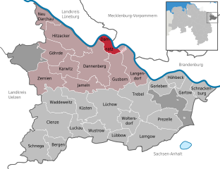
Эльбтальауэ (Elbtalaue, Samtgemeinde Elbtalaue)
- коммуна в Нижней Саксонии
 Hiking in Эльбтальауэ
Elbtalaue, located in the Lower Saxony region of Germany, is part of the scenic Elbe River valley, known for its unique landscapes, natural beauty, and rich cultural heritage. This area offers a wonderful opportunity for hiking enthusiasts of all skill levels, with a variety of trails that wind through lush forests, past rivers, and through charming villages.
Key Features of Hiking in Elbtalaue:
-
Scenic Trails: The region boasts an extensive network of hiking trails, ranging from easy walks to more challenging hikes. Many trails follow the banks of the Elbe River, showcasing picturesque views and serene natural surroundings.
-
Natural Diversity: Elbtalaue is characterized by a mix of floodplain forests, meadows, marshes, and dramatic river landscapes. Hikers can encounter a variety of flora and fauna, including migratory birds, making it a great destination for nature lovers.
-
Cultural Heritage: The area is dotted with historical sites, including charming villages, old mills, and churches. Hiking can be combined with exploring local history and architecture.
-
Wildlife Watching: The region is known for its biodiversity. Keep an eye out for local wildlife such as deer, rabbits, and various bird species, especially in areas designated as nature reserves.
-
Accessibility: Many trails are well-marked and easily accessible, making it suitable for families and casual walkers. Some paths lead to higher vantage points, offering breathtaking views of the surrounding countryside.
-
Local Gastronomy: After a day of hiking, you can enjoy the local cuisine in nearby towns and villages. Look out for traditional dishes and local products.
Tips for Hiking in Elbtalaue:
-
Best Time to Hike: Late spring to early autumn is typically the best time for hiking in this region due to milder weather and accessible trails.
-
Trail Maps: It's advisable to carry a map or download the hiking trails onto your smartphone for easy navigation.
-
Check Weather Conditions: Be aware of the local weather forecast before heading out, as conditions can change quickly.
-
Stay Hydrated and Prepared: Bring enough water, appropriate gear, and snacks for your hike, especially if you plan on tackling longer trails.
-
Respect Nature: Stay on marked paths, adhere to local guidelines, and practice Leave No Trace principles to preserve the natural beauty of Elbtalaue.
Suggested Hiking Routes:
-
Elbe Cycle Path (Elberadweg): This long-distance path follows the Elbe River, offering stunning views and a chance to explore various sections on foot.
-
Nature Reserves: Areas like the Lüneburg Heath or the Elbe-Diesel Natural Park provide well-maintained trails for a more immersive experience in nature.
-
Village Trails: Enjoy shorter hikes that connect charming villages, where you can experience the local culture and hospitality.
Overall, hiking in Elbtalaue is a wonderful way to connect with nature, enjoy the tranquility of the Elbe River valley, and explore the rich cultural backdrop of this beautiful region.
- Страна:

- Координаты: 53° 6' 0" N, 11° 6' 0" E


- GPS треки (wikiloc): [Ссылка]
- Площадь: 422.39 кв.км
- Население: 20850
- Веб сайт: http://www.elbtalaue.de/
- Википедия английская: wiki(en)
- Википедия национальная: wiki(de)
- Хранилище Wikidata: Wikidata: Q320195
- код Freebase: [/m/02v_wh6]
- код Freebase: [/m/02v_wh6]
- код региона Германии: 033545406
- код региона Германии: 033545406
Включает регионы:


Цернин
Hiking in Цернин
Zernien is a small village located in Lower Saxony, Germany, known for its picturesque landscapes and proximity to nature. While it might not be as famous as some larger hiking destinations, it offers several opportunities for outdoor enthusiasts looking to enjoy peaceful walks and explore the beautiful scenery of the area....
- Страна:
- Почтовый код: 29499
- Телефонный код: 05863
- Код автомобильного номера: DAN
- Координаты: 53° 4' 6" N, 10° 53' 0" E
- GPS треки (wikiloc): [Ссылка]
- Высота над уровнем моря: 100 м m
- Площадь: 51.55 кв.км
- Население: 1622
- Веб сайт: [Ссылка]


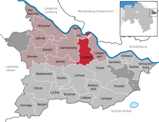
Данненберг
- город в Германии
Hiking in Данненберг
Dannenberg (Elbe), located in Lower Saxony, Germany, is a charming town that offers a variety of hiking opportunities, primarily in the surrounding countryside and along the banks of the Elbe River. Here are some highlights and tips for hiking in this area:...
- Страна:
- Почтовый код: 29451
- Телефонный код: 05861
- Код автомобильного номера: DAN
- Координаты: 53° 5' 0" N, 11° 5' 0" E
- GPS треки (wikiloc): [Ссылка]
- Высота над уровнем моря: 14 м m
- Площадь: 76.31 кв.км
- Население: 8330
- Веб сайт: [Ссылка]


Гёрде
Hiking in Гёрде
Göhrde is a beautiful area located in Lower Saxony, Germany, known for its dense forests and picturesque landscapes. It offers a variety of hiking opportunities, making it a fantastic destination for both casual walkers and serious hikers. Here are some key points about hiking in Göhrde:...
- Страна:
- Почтовый код: 29473
- Телефонный код: 05862
- Код автомобильного номера: DAN
- Координаты: 53° 9' 0" N, 10° 53' 0" E
- GPS треки (wikiloc): [Ссылка]
- Высота над уровнем моря: 44 м m
- Площадь: 40.71 кв.км
- Население: 593
- Веб сайт: [Ссылка]


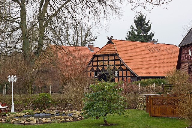
Хитцаккер
- город в Германии
Hiking in Хитцаккер
Hitzacker, located in the Lower Saxony region of Germany, is a charming town known for its picturesque landscapes and riverside views. Hiking in and around Hitzacker offers a wonderful blend of natural beauty, historical sites, and serene paths, ideal for both casual walkers and more experienced hikers....
- Страна:
- Почтовый код: 29456
- Телефонный код: 05861; 05862
- Код автомобильного номера: DAN
- Координаты: 53° 8' 0" N, 11° 3' 0" E
- GPS треки (wikiloc): [Ссылка]
- Высота над уровнем моря: 17 м m
- Площадь: 58.44 кв.км
- Население: 4904
- Веб сайт: [Ссылка]


Ямельн
Hiking in Ямельн
Jameln is a small village located in Lower Saxony, Germany. While it may not be widely recognized as a hiking destination, the surrounding areas offer opportunities for walking and exploring nature....
- Страна:
- Почтовый код: 29479
- Телефонный код: 05864
- Код автомобильного номера: DAN
- Координаты: 53° 3' 0" N, 11° 5' 0" E
- GPS треки (wikiloc): [Ссылка]
- Высота над уровнем моря: 29 м m
- Площадь: 35.84 кв.км
- Население: 1036
- Веб сайт: [Ссылка]


Ной-Дархау
Hiking in Ной-Дархау
Neu Darchau is a small village located in Lower Saxony, Germany, near the Elbe River. While it's not a major hiking destination, the surrounding area offers several opportunities for outdoor activities, including hiking. Here are some things to consider for hiking in and around Neu Darchau:...
- Страна:
- Почтовый код: 29490
- Телефонный код: 05853
- Код автомобильного номера: DAN
- Координаты: 53° 13' 44" N, 10° 53' 7" E
- GPS треки (wikiloc): [Ссылка]
- Высота над уровнем моря: 15 м m
- Площадь: 22.73 кв.км
- Население: 1370
- Веб сайт: [Ссылка]

Дамнац
Hiking in Дамнац
Damnatz is a small village located in the Lüneburg district of Lower Saxony, Germany. While it may not be as well-known as some larger hiking destinations, it offers a peaceful environment and opportunities for nature walks and hiking in the surrounding areas....
- Страна:
- Почтовый код: 29472
- Телефонный код: 05865
- Код автомобильного номера: DAN
- Координаты: 53° 8' 11" N, 11° 10' 37" E
- GPS треки (wikiloc): [Ссылка]
- Высота над уровнем моря: 16 м m
- Площадь: 16.25 кв.км
- Население: 284
- Веб сайт: [Ссылка]

Карвиц
Hiking in Карвиц
Karwitz is a village located in Lower Saxony, Germany, and while it might not be as widely recognized as some other hiking destinations, it offers natural beauty and opportunities for outdoor activities. Here are some aspects to consider if you're planning a hiking trip around Karwitz:...
- Страна:
- Почтовый код: 29481
- Телефонный код: 05861
- Код автомобильного номера: DAN
- Координаты: 53° 5' 0" N, 11° 1' 0" E
- GPS треки (wikiloc): [Ссылка]
- Высота над уровнем моря: 28 м m
- Площадь: 31.65 кв.км
- Население: 726
- Веб сайт: [Ссылка]

Гусборн
Hiking in Гусборн
It seems that "Gusborn" might not be a widely recognized hiking destination or may refer to a specific, lesser-known area. However, if you meant a popular hiking destination or region, here are some general tips for hiking in similar areas:...
- Страна:
- Почтовый код: 29476
- Телефонный код: 05865
- Код автомобильного номера: DAN
- Координаты: 53° 4' 59" N, 11° 13' 0" E
- GPS треки (wikiloc): [Ссылка]
- Высота над уровнем моря: 17 м m
- Площадь: 48.3 кв.км
- Население: 1194
- Веб сайт: [Ссылка]


Лангендорф
Hiking in Лангендорф
Langendorf, located in Lower Saxony, Germany, is a small village that offers a peaceful environment for hiking enthusiasts. While it may not be as well-known as some larger hiking destinations, the surrounding natural landscapes provide a great opportunity for outdoor activities....
- Страна:
- Почтовый код: 29484
- Телефонный код: 05865
- Код автомобильного номера: DAN
- Координаты: 53° 6' 0" N, 11° 15' 0" E
- GPS треки (wikiloc): [Ссылка]
- Высота над уровнем моря: 23 м m
- Площадь: 40.87 кв.км
- Население: 685
- Веб сайт: [Ссылка]