
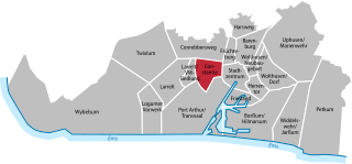
Эмден (Emden, Emden)

- город в Восточной Фризии в Германии
 Hiking in Эмден
Emden, located in the northern part of Germany in the state of Lower Saxony, is not predominantly known for mountainous hiking trails but offers some charming walking and hiking opportunities. Here are some aspects to consider for hiking in and around Emden:
-
Surrounding Nature: While Emden itself doesn't have mountains or rugged terrain, it is surrounded by the beautiful landscapes of the East Frisian region. The flat terrain is ideal for long walks, cycling, and enjoying the natural scenery.
-
Parks and Reserves: You can explore parks like the "Emscher Landschaftspark" or the "Emder Stadtwald," which offer various trails and paths suitable for leisurely hikes. The accessibility and flat trails make them perfect for families and casual walkers.
-
Waterfront Trails: Emden is located near the River Ems and the North Sea coast, offering lovely waterfront walks. These areas are particularly beautiful during sunrise or sunset and provide opportunities for bird-watching and enjoying the local flora and fauna.
-
Nearby Hiking Areas: To experience more diverse rural landscapes, consider taking day trips to nearby nature reserves and national parks, such as the "Meyer Werft’s Visitor Center," where you can combine hiking with an educational experience about shipbuilding.
-
Coastal Paths: The nearby East Frisian Islands, like Borkum and Norderney, can be accessed via ferry and offer stunning coastal hikes along sandy beaches and dunes.
Tips:
- Check local weather conditions before heading out, as the area can be subject to quick changes in weather.
- Bring plenty of water and snacks, especially since some hiking trails might be less frequented.
- Make use of local maps and guides to find the best trails suited to your hiking level.
Overall, while Emden may not be a traditional hiking hotspot, it offers pleasant walking experiences amidst beautiful natural surroundings.
- Страна:

- Почтовый код: 26725; 26723; 26721
- Телефонный код: 04924; 04927; 04921
- Код автомобильного номера: EMD
- Координаты: 53° 22' 1" N, 7° 12' 22" E


- GPS треки (wikiloc): [Ссылка]
- Высота над уровнем моря: 1 м m
- Площадь: 112.34 кв.км
- Население: 50486
- Веб сайт: https://www.emden.de/
- Википедия русская: wiki(ru)
- Википедия английская: wiki(en)
- Википедия национальная: wiki(de)
- Хранилище Wikidata: Wikidata: Q4174
- Галерея изображений в википедии: [Ссылка]
- Катеория в википедии: [Ссылка]
- код Freebase: [/m/019y81]
- код GeoNames: Альт: [2930596]
- код VIAF: Альт: [247156416]
- ID отношения в OpenStreetMap: [5409531]
- код GND: Альт: [4014564-5]
- идентификатор местоположения ArchINFORM: [347]
- место в MusicBrainz: [5fa17a4f-79c3-4256-8c1c-6dbb44e2fe70]
- код в энциклопедии «Британника онлайн»: [place/Emden-Germany]
- код в Большой каталанской энциклопедии: [0023910]
- EMLO location ID: [ade51a4c-99a3-42eb-b6af-01ebe63d5828]
- код NUTS: [DE942]
- Nomisma ID: [emden]
- идентификатор муниципалитетов в Германии: 03402000
- код US National Archives: 10044649
- код района Германии: 03402
Включает регионы:
Conrebbersweg
Hiking in Conrebbersweg
Conrebbersweg, located near the city of Groningen in the Netherlands, is a scenic area that offers opportunities for hiking and exploring nature. While the Conrebbersweg itself is primarily a road, the surrounding regions provide various trails and paths for outdoor enthusiasts. Here’s what you can expect when hiking in this area:...
- Страна:
- Почтовый код: 26721
- Телефонный код: 04921
- Координаты: 53° 23' 2" N, 7° 11' 33" E
- GPS треки (wikiloc): [Ссылка]

Constantia
Hiking in Constantia
Constantia, located in the Emden district of Germany, offers a variety of outdoor activities, including hiking, although it is not as widely recognized as some other hiking destinations in the country. The area is characterized by its flat landscapes, picturesque meadows, and scenic waterways, making it an enjoyable location for leisurely walks and hikes....
- Страна:
- Почтовый код: 26723
- Телефонный код: 04921
- Координаты: 53° 22' 4" N, 7° 10' 50" E
- GPS треки (wikiloc): [Ссылка]
Logumer Vorwerk
Hiking in Logumer Vorwerk
Logumer Vorwerk is a beautiful area located in the East Frisian region of Germany, known for its flat landscapes and picturesque countryside. While it may not be as mountainous as other hiking destinations, it offers unique trails that allow hikers to enjoy the tranquility of the region, along with its rich flora and fauna....
- Страна:
- Почтовый код: 26723
- Телефонный код: 04921
- Координаты: 53° 21' 6" N, 7° 7' 58" E
- GPS треки (wikiloc): [Ссылка]
- Высота над уровнем моря: 1 м m
Petkum
Hiking in Petkum
Petkum is a district located in the city of Emden, Germany. While it may not be widely known as a hiking destination, there are still opportunities for outdoor activities in the surrounding areas. Here’s what you can typically expect when hiking in and around Petkum:...
- Страна:
- Почтовый код: 26725
- Телефонный код: 04921
- Координаты: 53° 20' 6" N, 7° 16' 20" E
- GPS треки (wikiloc): [Ссылка]
- Высота над уровнем моря: 1 м m
Früchteburg
Hiking in Früchteburg
Früchteburg is a lesser-known but beautiful hiking destination that offers picturesque landscapes, lush greenery, and a variety of trails for different skill levels. When planning a hike in Früchteburg, here are some key points to consider:...
- Страна:
- Почтовый код: 26721
- Телефонный код: 04921
- Координаты: 53° 22' 35" N, 7° 12' 4" E
- GPS треки (wikiloc): [Ссылка]
Harsweg
Hiking in Harsweg
Harsweg is not a widely recognized hiking destination, and there may be some confusion regarding the name. However, if you are referring to a specific area, region, or trail known locally as Harsweg, I can provide general hiking tips and advice that can apply to most hiking locations....
- Страна:
- Почтовый код: 26721
- Телефонный код: 04921
- Координаты: 53° 23' 30" N, 7° 12' 27" E
- GPS треки (wikiloc): [Ссылка]
- Высота над уровнем моря: 1 м m
- Площадь: 1.76 кв.км
- Население: 993
Herrentor
Hiking in Herrentor
It seems like there might be a bit of confusion regarding the name "Herrentor." As of my last knowledge update in October 2023, there isn't a well-known hiking destination specifically named Herrentor. However, it's possible you are referring to a local feature, trail, or area that is not widely recognized, or it might be a misspelling or variation of a different hiking area....
- Страна:
- Почтовый код: 26725
- Телефонный код: 04921
- Координаты: 53° 21' 44" N, 7° 13' 11" E
- GPS треки (wikiloc): [Ссылка]
Larrelt
Hiking in Larrelt
Larrelt, often considered a hidden gem, offers a variety of hiking opportunities for outdoor enthusiasts. Although it may not be as widely known as some other hiking destinations, it provides peaceful trails and beautiful natural scenery. Here are some key aspects to consider when hiking in Larrelt:...
- Страна:
- Почтовый код: 26723
- Телефонный код: 04921
- Координаты: 53° 21' 54" N, 7° 8' 52" E
- GPS треки (wikiloc): [Ссылка]
- Высота над уровнем моря: 1 м m
Port Arthur/Transvaal
Hiking in Port Arthur/Transvaal
Port Arthur, located in the Transvaal region of South Africa (now known as Gauteng), offers a variety of hiking opportunities amidst beautiful landscapes and rich historical context. Here are some key points to consider when planning a hiking trip in this area:...
- Страна:
- Почтовый код: 26723
- Телефонный код: 04921
- Координаты: 53° 21' 36" N, 7° 11' 13" E
- GPS треки (wikiloc): [Ссылка]
- Высота над уровнем моря: 1 м m
- Площадь: 11.641 кв.км


Widdelswehr
Hiking in Widdelswehr
Widdelswehr is a beautiful area located in the Lüneburg Heath region of Germany, known for its scenic landscapes and diverse wildlife. Hiking in Widdelswehr offers a range of trails that cater to various skill levels, making it an excellent destination for both beginners and experienced hikers....
- Страна:
- Почтовый код: 26725
- Телефонный код: 04921
- Координаты: 53° 20' 11" N, 7° 15' 39" E
- GPS треки (wikiloc): [Ссылка]


Wolthusen
Hiking in Wolthusen
Wolthusen is a scenic area located in the picturesque region of the Swiss Alps. Although it may not be as widely recognized as other hiking destinations, it offers a range of beautiful trails suitable for various skill levels. Here’s a brief overview of what to expect when hiking in Wolthusen:...
- Страна:
- Почтовый код: 26725
- Телефонный код: 04921
- Координаты: 53° 22' 15" N, 7° 13' 55" E
- GPS треки (wikiloc): [Ссылка]
Wybelsum
Hiking in Wybelsum
Wybelsum is a charming village located in Lower Saxony, Germany, not far from the city of Emden. While it may not be as widely recognized as some major hiking destinations, it offers a unique experience for those looking to explore the natural beauty of the region. Here are some aspects of hiking in and around Wybelsum:...
- Страна:
- Почтовый код: 26723
- Телефонный код: 04921
- Координаты: 53° 21' 16" N, 7° 6' 38" E
- GPS треки (wikiloc): [Ссылка]
- Высота над уровнем моря: 1 м m
Uphusen
Hiking in Uphusen
Uphusen is a small district located near the town of Hameln in Lower Saxony, Germany. While it may not be as widely known as some major hiking destinations, it offers several opportunities for outdoor enthusiasts to explore the beautiful landscapes of the region....
- Страна:
- Почтовый код: 26725
- Телефонный код: 04921
- Координаты: 53° 22' 42" N, 7° 15' 15" E
- GPS треки (wikiloc): [Ссылка]


Twixlum
Hiking in Twixlum
Twixlum is not a widely recognized hiking location, and it may not have established trails or notable features associated with it. However, if you're referring to hiking in a specific region or area that is locally known by that name, I would recommend checking local hiking resources, trail maps, or community forums for the latest information....
- Страна:
- Почтовый код: 26723
- Телефонный код: 04921
- Координаты: 53° 22' 18" N, 7° 7' 56" E
- GPS треки (wikiloc): [Ссылка]
- Высота над уровнем моря: 1 м m


Barenburg
Hiking in Barenburg
Barenburg, located in the Emden region of Germany, is not traditionally known as a major hiking destination like some of the more mountainous areas of the country. However, it offers a peaceful, rural landscape that can be appealing for those looking to enjoy nature and explore the outdoors....
- Страна:
- Почтовый код: 26721
- Телефонный код: 04921
- Координаты: 53° 22' 43" N, 7° 12' 49" E
- GPS треки (wikiloc): [Ссылка]
- Площадь: 2.491 кв.км


Borssum
Hiking in Borssum
Borssum is a small village located in the region of East Frisia in Lower Saxony, Germany. While it may not be as widely known for hiking as larger national parks or mountain ranges, it offers some charming trails and scenic views suitable for leisurely walks and light hiking....
- Страна:
- Почтовый код: 26725
- Телефонный код: 04921
- Координаты: 53° 20' 36" N, 7° 13' 28" E
- GPS треки (wikiloc): [Ссылка]
Граничит с регионами:

Аурих
Hiking in Аурих
Aurich, located in the East Frisian region of Lower Saxony, Germany, is not as mountainous as other hiking destinations but offers a unique and picturesque setting for those who enjoy walking and exploring nature. Here are some aspects to consider when hiking in the Aurich district:...
- Страна:
- Код автомобильного номера: AUR; NOR
- Координаты: 53° 30' 0" N, 7° 19' 48" E
- GPS треки (wikiloc): [Ссылка]
- Высота над уровнем моря: 2 м m
- Площадь: 1287.00 кв.км
- Население: 190066
- Веб сайт: [Ссылка]


Лер
Hiking in Лер
Leer is a district located in the Lower Saxony region of Germany, and it offers a variety of opportunities for hiking enthusiasts. The landscape is characterized by flat terrain, picturesque wetlands, canals, and rivers, making it a unique area for outdoor activities....
- Страна:
- Код автомобильного номера: LER
- Координаты: 53° 15' 0" N, 7° 30' 0" E
- GPS треки (wikiloc): [Ссылка]
- Высота над уровнем моря: 1 м m
- Площадь: 1086.00 кв.км
- Население: 168253
- Веб сайт: [Ссылка]