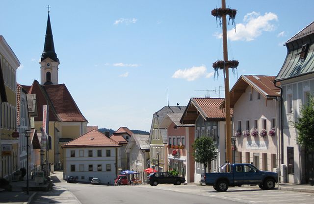
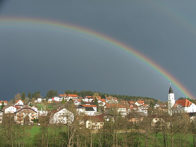
Энгельхартсцелль-на-Дунае (Engelhartszell an der Donau, Engelhartszell)
 Hiking in Энгельхартсцелль-на-Дунае
Engelhartszell an der Donau, located in the Austrian region of Upper Austria, is a charming destination for hikers and nature enthusiasts. It’s nestled along the banks of the Danube River and offers a variety of scenic trails that showcase the natural beauty of the area.
Hiking Trails:
-
Danube Cycle Path: One of the most popular trails runs along the Danube River, offering stunning views of the river, surrounding hills, and vineyards. This flat, well-maintained path is also suited for cycling.
-
Waldkirchen Trail: This trail takes you into the nearby forests and hills. It features moderate ascents and descents, perfect for intermediate hikers looking for a real nature experience. There are atmospheric views of both the Danube and the lush landscape.
-
Cultural Trails: Engelhartszell features a few cultural and historical trails that allow hikers to explore local sights, such as historical churches, monasteries, and traditional villages. These paths combine physical activity with cultural enrichment.
Highlights:
-
Engelhartszell Monastery: As you hike, consider visiting the local monastery, known for its beautiful architecture and serene ambiance. It adds a historical context to your hiking adventure.
-
Flora and Fauna: The area is rich in biodiversity, with opportunities to spot various bird species and local wildlife along the trails.
-
Scenic Views: Many trails provide breathtaking views of the Danube, particularly at sunrise or sunset, making for unforgettable hiking experiences.
Tips for Hiking in Engelhartszell:
- Gear Up: Wear appropriate hiking footwear and dress in layers, as temperatures can vary significantly, especially in the spring and autumn.
- Hydration & Snacks: Carry enough water and snacks to keep your energy up while hiking.
- Maps & Guides: Use local maps or apps that highlight trails to avoid getting lost and to discover new paths.
- Respect Nature: Follow the Leave No Trace principles to keep the trails clean and beautiful for everyone.
Whether you're looking for a leisurely walk or a more challenging hike, Engelhartszell an der Donau offers something for everyone. Enjoy the blend of nature and culture, and make the most of your hiking adventure in this beautiful region!
- Страна:

- Почтовый код: 4090
- Телефонный код: 07717
- Код автомобильного номера: SD
- Координаты: 48° 30' 0" N, 13° 44' 0" E


- GPS треки (wikiloc): [Ссылка]
- Высота над уровнем моря: 302 м m
- Площадь: 19 кв.км
- Население: 942
- Веб сайт: http://www.engelhartszell.at/
- Википедия русская: wiki(ru)
- Википедия английская: wiki(en)
- Википедия национальная: wiki(de)
- Хранилище Wikidata: Wikidata: Q660958
- Катеория в википедии: [Ссылка]
- код Freebase: [/m/03gvbl2]
- код GeoNames: Альт: [2780072]
- код GND: Альт: [4342017-5]
- идентификатор местоположения ArchINFORM: [9144]
- код LCNAF: Альт: [no00100487]
- место в MusicBrainz: [5ef59144-b1cf-4325-b06b-c7ceb622dd8b]
- код австрийского муниципалитета: [41407]
Граничит с регионами:

Унтергрисбах
Hiking in Унтергрисбах
Untergriesbach, located in Bavaria, Germany, is a charming area surrounded by beautiful natural landscapes, making it an excellent destination for hiking enthusiasts. Here are some key points about hiking in and around Untergriesbach:...
- Страна:

- Почтовый код: 94107; W-8391; 8391
- Телефонный код: 08593
- Код автомобильного номера: PA
- Координаты: 48° 34' 25" N, 13° 40' 2" E
- GPS треки (wikiloc): [Ссылка]
- Высота над уровнем моря: 556 м m
- Площадь: 73.61 кв.км
- Население: 5814
- Веб сайт: [Ссылка]

Фихтенштайн
Hiking in Фихтенштайн
Vichtenstein, nestled in the heart of Europe, is recognized for its stunning landscapes, which include mountains, valleys, and picturesque villages. While you might be referring to "Liechtenstein," the charming, landlocked principality between Switzerland and Austria, it's a fantastic destination for hiking enthusiasts....
- Страна:
- Почтовый код: 4091
- Телефонный код: 07714
- Код автомобильного номера: SD
- Координаты: 48° 32' 0" N, 13° 39' 0" E
- GPS треки (wikiloc): [Ссылка]
- Высота над уровнем моря: 554 м m
- Площадь: 10.7 кв.км
- Население: 611
- Веб сайт: [Ссылка]


Вальдкирхен-на-Везене
Hiking in Вальдкирхен-на-Везене
Waldkirchen am Wesen is a charming village located in the beautiful region of Austria, specifically in the Upper Austria province. Nestled among the rolling hills and lush forests, it provides a fantastic backdrop for hikers of all levels. Here are some highlights and tips for hiking in this scenic area:...
- Страна:
- Почтовый код: 4085
- Телефонный код: 07718
- Код автомобильного номера: SD
- Координаты: 48° 27' 0" N, 13° 49' 0" E
- GPS треки (wikiloc): [Ссылка]
- Высота над уровнем моря: 550 м m
- Площадь: 21.4 кв.км
- Население: 1171
- Веб сайт: [Ссылка]


Санкт-Эгиди
Hiking in Санкт-Эгиди
Sankt Aegidi, located in Austria, offers a variety of hiking opportunities that allow you to enjoy the stunning landscapes of the region. The area is characterized by its picturesque rolling hills, lush green meadows, and scenic views of the surrounding mountains....
- Страна:
- Почтовый код: 4725
- Телефонный код: 07717
- Код автомобильного номера: SD
- Координаты: 48° 29' 0" N, 13° 44' 0" E
- GPS треки (wikiloc): [Ссылка]
- Высота над уровнем моря: 599 м m
- Площадь: 29 кв.км
- Население: 1556
- Веб сайт: [Ссылка]

Санкт-Роман
Hiking in Санкт-Роман
Sankt Roman, located in Upper Austria, offers a variety of hiking opportunities that cater to different skill levels and preferences. Nestled within a picturesque landscape of rolling hills, forests, and meadows, it provides a tranquil escape for nature lovers and outdoor enthusiasts....
- Страна:
- Почтовый код: 4793
- Телефонный код: 07716
- Код автомобильного номера: SD
- Координаты: 48° 28' 55" N, 13° 36' 40" E
- GPS треки (wikiloc): [Ссылка]
- Высота над уровнем моря: 569 м m
- Площадь: 31.77 кв.км
- Население: 1711
- Веб сайт: [Ссылка]
Копфинг
Hiking in Копфинг
Kopfing im Innkreis, located in Austria's Upper Austria region, offers a charming environment for hiking enthusiasts. The area is characterized by beautiful landscapes, rolling hills, and serene natural settings, making it perfect for a variety of hiking trails suitable for different skill levels....
- Страна:
- Почтовый код: 4794
- Телефонный код: 07763
- Код автомобильного номера: SD
- Координаты: 48° 25' 59" N, 13° 39' 0" E
- GPS треки (wikiloc): [Ссылка]
- Высота над уровнем моря: 547 м m
- Площадь: 33.34 кв.км
- Население: 2008
- Веб сайт: [Ссылка]

Нойстифт
Hiking in Нойстифт
Neustift im Mühlkreis, located in the picturesque Mühlviertel region of Austria, offers a variety of hiking opportunities that cater to all levels of hikers. This area is known for its beautiful natural landscapes, rolling hills, dense forests, and stunning views of the surrounding countryside....
- Страна:
- Почтовый код: 4143
- Телефонный код: 07284
- Код автомобильного номера: RO
- Координаты: 48° 31' 44" N, 13° 45' 22" E
- GPS треки (wikiloc): [Ссылка]
- Высота над уровнем моря: 591 м m
- Площадь: 20 кв.км
- Население: 1461
- Веб сайт: [Ссылка]

Хофкирхен
Hiking in Хофкирхен
Hofkirchen im Mühlkreis, located in Upper Austria, is a beautiful area offering a variety of hiking opportunities. It's surrounded by picturesque landscapes, rolling hills, and lush forests, making it a great destination for both novice and experienced hikers....
- Страна:
- Почтовый код: 4142
- Телефонный код: 07285
- Код автомобильного номера: RO
- Координаты: 48° 29' 2" N, 13° 48' 43" E
- GPS треки (wikiloc): [Ссылка]
- Высота над уровнем моря: 601 м m
- Площадь: 23 кв.км
- Население: 1520
- Веб сайт: [Ссылка]