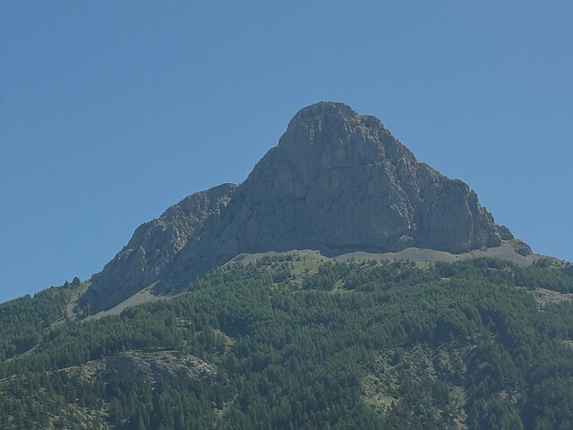
Антрон (Entraunes, Entraunes)

- коммуна в департаменте Приморские Альпы, регион Прованс — Альпы — Лазурный Берег, Франция
 Hiking in Антрон
Entraunes, located in the Alpes-Maritimes region of France, is a beautiful destination for hiking enthusiasts. Nestled in the Mercantour National Park, it offers stunning natural landscapes, diverse flora and fauna, and a variety of trails that cater to different skill levels.
Key Highlights of Hiking in Entraunes:
-
Scenic Trails: The area features numerous hiking trails ranging from easy walks to more challenging treks. Popular routes often lead to breathtaking viewpoints, pristine lakes, and scenic mountain passes.
-
Mercantour National Park: As part of this national park, hikers can experience a protected environment with unique biodiversity, including rare species of plants and animals. Wildlife such as chamois, ibex, and various bird species can be spotted along the trails.
-
Cultural Heritage: Hiking in Entraunes also offers opportunities to explore local culture. The village itself has historical architecture, and there are remnants of ancient sheepfolds and old pathways that tell the story of the region's agricultural past.
-
Seasonal Considerations: Spring and summer are the most popular times for hiking in Entraunes; however, autumn also provides a spectacular display of fall colors. Winter hikes can be a bit more challenging due to snow, so snowshoes or specialized gear may be necessary.
-
Preparation: As with any hiking activity, it's crucial to prepare adequately. Check trail conditions, dress in layers, carry ample water and snacks, and make sure to have maps or a GPS device. Hiring a local guide can enhance your experience, especially if you're unfamiliar with the area.
-
Safety: Always prioritize safety by informing someone about your hiking plans, being mindful of weather changes, and sticking to marked trails.
Recommended Trails:
- Lac de Rabuons: A moderate hike that rewards you with stunning views of the lake and surrounding peaks.
- Sentier des Merveilles: Offers a mix of natural and archaeological highlights, featuring ancient rock engravings.
Entraunes presents an excellent opportunity for both novice and experienced hikers to explore the beauty of the French Alps while enjoying the tranquility of nature. Whether you're aiming for a day hike or a longer trekking adventure, the area has much to offer.
- Страна:

- Почтовый код: 06470
- Координаты: 44° 11' 17" N, 6° 44' 54" E


- GPS треки (wikiloc): [Ссылка]
- Площадь: 81.45 кв.км
- Население: 118
- Википедия русская: wiki(ru)
- Википедия английская: wiki(en)
- Википедия национальная: wiki(fr)
- Хранилище Wikidata: Wikidata: Q576476
- Катеория в википедии: [Ссылка]
- код Freebase: [/m/03m4_m9]
- код Freebase: [/m/03m4_m9]
- код GeoNames: Альт: [3020137]
- код GeoNames: Альт: [3020137]
- номер SIREN: [210600565]
- номер SIREN: [210600565]
- код BNF: [119554157]
- код BNF: [119554157]
- код VIAF: Альт: [240395385]
- код VIAF: Альт: [240395385]
- Natura 2000 site ID: Альт: [FR9301549]
- Common Database on Designated Areas ID: [FR9301549]
- Natura 2000 site ID: Альт: [FR9301549]
- Common Database on Designated Areas ID: [FR9301549]
- код муниципалитета INSEE: 06056
- код муниципалитета INSEE: 06056
Граничит с регионами:
Юверне-Фур
- коммуна во Франции
Hiking in Юверне-Фур
Uvernet-Fours is a charming destination in the French Alpes-de-Haute-Provence region, known for its beautiful landscapes and outdoor recreational opportunities, including hiking. Here are some details to help you plan your hiking experience in this area:...
- Страна:
- Почтовый код: 04400
- Координаты: 44° 21' 40" N, 6° 37' 34" E
- GPS треки (wikiloc): [Ссылка]
- Площадь: 135.44 кв.км
- Население: 583
Кольмар
- коммуна - Прованс — Альпы — Лазурный Берег, Альпы Верхнего Прованса, Кастеллан, Алло-Кольмар
Hiking in Кольмар
Colmars is a charming village located in the Alpes-de-Haute-Provence region of France. It's an excellent destination for hiking enthusiasts, offering stunning landscapes, rich biodiversity, and a taste of the local culture. Here are some highlights regarding hiking in Colmars:...
- Страна:
- Почтовый код: 04370
- Координаты: 44° 10' 52" N, 6° 37' 36" E
- GPS треки (wikiloc): [Ссылка]
- Площадь: 81.82 кв.км
- Население: 431


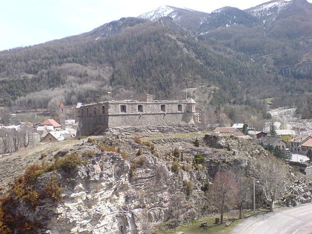
Шатонёф-д’Антрон
- коммуна в департаменте Приморские Альпы, регион Прованс — Альпы — Лазурный Берег, Франция
Hiking in Шатонёф-д’Антрон
Châteauneuf-d'Entraunes is a picturesque village located in the Alpes-Maritimes department of France. Nestled in the Mercantour National Park, it offers a variety of hiking opportunities suitable for different levels of experience. Here are some highlights and tips for hiking in this beautiful area:...
- Страна:
- Почтовый код: 06470
- Координаты: 44° 7' 42" N, 6° 49' 56" E
- GPS треки (wikiloc): [Ссылка]
- Площадь: 29.91 кв.км
- Население: 47
- Веб сайт: [Ссылка]


Сен-Мартен-д’Антрон
- коммуна в департаменте Приморские Альпы, регион Прованс — Альпы — Лазурный Берег, Франция
Hiking in Сен-Мартен-д’Антрон
Saint-Martin-d'Entraunes is a beautiful village located in the Alpes-Maritimes region of France, nestled within the stunning Mercantour National Park. The area is characterized by its rugged mountains, lush valleys, and spectacular natural landscapes. Hiking in Saint-Martin-d'Entraunes offers a variety of trails suitable for all skill levels, making it a great destination for both beginners and experienced hikers....
- Страна:
- Почтовый код: 06470
- Координаты: 44° 8' 31" N, 6° 45' 44" E
- GPS треки (wikiloc): [Ссылка]
- Площадь: 40.05 кв.км
- Население: 121

Сен-Дальма-ле-Сельваж
- коммуна в департаменте Приморские Альпы, регион Прованс — Альпы — Лазурный Берег, Франция
Hiking in Сен-Дальма-ле-Сельваж
Saint-Dalmas-le-Selvage is a beautiful village located in the Alpes-Maritimes department in southeastern France, known for its stunning mountain scenery and access to numerous hiking trails. Here are some highlights and tips for hiking in the area:...
- Страна:
- Почтовый код: 06660
- Координаты: 44° 17' 5" N, 6° 51' 58" E
- GPS треки (wikiloc): [Ссылка]
- Площадь: 81.03 кв.км
- Население: 122

Алло
Hiking in Алло
Allos is a fantastic destination for hiking, situated in the Alpes-de-Haute-Provence region of France. Known for its stunning natural landscapes and diverse terrain, Allos offers a variety of trails suitable for hikers of all levels. Here are some highlights of hiking in the Allos area:...
- Страна:
- Почтовый код: 04260
- Координаты: 44° 14' 25" N, 6° 37' 41" E
- GPS треки (wikiloc): [Ссылка]
- Площадь: 116.65 кв.км
- Население: 697

Сент-Этьен-де-Тине
- коммуна в департаменте Приморские Альпы, регион Прованс — Альпы — Лазурный Берег, Франция
Hiking in Сент-Этьен-де-Тине
Saint-Étienne-de-Tinée is a charming village located in the Alpes-Maritimes region of southeastern France, nestled in the Tinée Valley. It serves as a great base for hikers looking to explore the stunning natural landscapes of the surrounding area, including the Mercantour National Park, which is renowned for its dramatic scenery and diverse wildlife....
- Страна:
- Почтовый код: 06660
- Координаты: 44° 15' 25" N, 6° 55' 29" E
- GPS треки (wikiloc): [Ссылка]
- Высота над уровнем моря: 1139 м m
- Площадь: 173.81 кв.км
- Население: 1468