Сен-Дальма-ле-Сельваж (Saint-Dalmas-le-Selvage, Saint-Dalmas-le-Selvage)
- коммуна в департаменте Приморские Альпы, регион Прованс — Альпы — Лазурный Берег, Франция
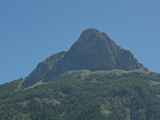
 Hiking in Сен-Дальма-ле-Сельваж
Saint-Dalmas-le-Selvage is a beautiful village located in the Alpes-Maritimes department in southeastern France, known for its stunning mountain scenery and access to numerous hiking trails. Here are some highlights and tips for hiking in the area:
1.
- The region offers various trails ranging from easy walks to more challenging hikes. The trails typically feature breathtaking views of the surrounding mountains, valleys, and forests.
- You can explore routes that lead to panoramic viewpoints, alpine lakes, and waterfalls.
2.
- The diverse ecosystems around Saint-Dalmas-le-Selvage are home to a range of plant and animal species. Keep an eye out for local wildlife, including birds, deer, and unique alpine flowers.
3.
- The area is accessible year-round, although the best hiking conditions are typically found in late spring to early autumn (May to October). Be mindful of the weather and trail conditions, especially in winter.
4.
- The Vallée des Merveilles: This area is famous for its prehistoric rock engravings and offers numerous hiking routes that can be explored.
- Col de la Bonette: One of the highest paved roads in Europe, with trails branching off from it that provide stunning views and varied landscapes.
5.
- Always check the weather forecast before heading out on a hike.
- Ensure you have the proper gear, including sturdy hiking boots, waterproof clothing, and sufficient food and water.
- Bring a map or GPS device, as some trails may not be well-marked.
- Let someone know your hiking plans and expected return time.
6.
- Respect local wildlife and plants; stick to marked trails to minimize your impact on the environment.
- Be aware of any seasonal restrictions or trail closures.
7.
- Take some time to explore the village itself, which features charming architecture and local culture, adding to the overall experience of your hiking trip.
Hiking in Saint-Dalmas-le-Selvage offers a blend of adventure, tranquility, and the opportunity to connect with nature. Enjoy your hiking experience!
- Страна:

- Почтовый код: 06660
- Координаты: 44° 17' 5" N, 6° 51' 58" E


- GPS треки (wikiloc): [Ссылка]
- Площадь: 81.03 кв.км
- Население: 122
- Википедия русская: wiki(ru)
- Википедия английская: wiki(en)
- Википедия национальная: wiki(fr)
- Хранилище Wikidata: Wikidata: Q867019
- Катеория в википедии: [Ссылка]
- код Freebase: [/m/03m4zzp]
- код Freebase: [/m/03m4zzp]
- код GeoNames: Альт: [2980929]
- код GeoNames: Альт: [2980929]
- номер SIREN: [210601191]
- номер SIREN: [210601191]
- код BNF: [135088268]
- код BNF: [135088268]
- код VIAF: Альт: [141055903]
- код VIAF: Альт: [141055903]
- код LCNAF: Альт: [no2002037739]
- код LCNAF: Альт: [no2002037739]
- место в MusicBrainz: [8d736b79-1838-4d48-b756-d35df530207d]
- место в MusicBrainz: [8d736b79-1838-4d48-b756-d35df530207d]
- код муниципалитета INSEE: 06119
- код муниципалитета INSEE: 06119
Граничит с регионами:
Юверне-Фур
- коммуна во Франции
Hiking in Юверне-Фур
Uvernet-Fours is a charming destination in the French Alpes-de-Haute-Provence region, known for its beautiful landscapes and outdoor recreational opportunities, including hiking. Here are some details to help you plan your hiking experience in this area:...
- Страна:
- Почтовый код: 04400
- Координаты: 44° 21' 40" N, 6° 37' 34" E
- GPS треки (wikiloc): [Ссылка]
- Площадь: 135.44 кв.км
- Население: 583

Жозье
- коммуна во Франции
Hiking in Жозье
Jausiers is a charming village located in the Alpes-de-Haute-Provence region of France. It's nestled in the heart of the French Alps and offers attractive hiking opportunities for outdoor enthusiasts. Here are some highlights about hiking in and around Jausiers:...
- Страна:
- Почтовый код: 04850
- Координаты: 44° 25' 4" N, 6° 43' 50" E
- GPS треки (wikiloc): [Ссылка]
- Площадь: 107.73 кв.км
- Население: 1133
- Веб сайт: [Ссылка]


Антрон
- коммуна в департаменте Приморские Альпы, регион Прованс — Альпы — Лазурный Берег, Франция
Hiking in Антрон
Entraunes, located in the Alpes-Maritimes region of France, is a beautiful destination for hiking enthusiasts. Nestled in the Mercantour National Park, it offers stunning natural landscapes, diverse flora and fauna, and a variety of trails that cater to different skill levels....
- Страна:
- Почтовый код: 06470
- Координаты: 44° 11' 17" N, 6° 44' 54" E
- GPS треки (wikiloc): [Ссылка]
- Площадь: 81.45 кв.км
- Население: 118

Сент-Этьен-де-Тине
- коммуна в департаменте Приморские Альпы, регион Прованс — Альпы — Лазурный Берег, Франция
Hiking in Сент-Этьен-де-Тине
Saint-Étienne-de-Tinée is a charming village located in the Alpes-Maritimes region of southeastern France, nestled in the Tinée Valley. It serves as a great base for hikers looking to explore the stunning natural landscapes of the surrounding area, including the Mercantour National Park, which is renowned for its dramatic scenery and diverse wildlife....
- Страна:
- Почтовый код: 06660
- Координаты: 44° 15' 25" N, 6° 55' 29" E
- GPS треки (wikiloc): [Ссылка]
- Высота над уровнем моря: 1139 м m
- Площадь: 173.81 кв.км
- Население: 1468