Антрево (Entrevaux, Entrevaux)
- коммуна во Франции
 Hiking in Антрево
Entrevaux, a picturesque medieval village situated in the Alpes-de-Haute-Provence region of France, offers a unique hiking experience characterized by stunning landscapes, rich history, and well-marked trails. Here are some details about hiking in and around Entrevaux:
Trails and Routes:
-
Historical Trails: Many trails in the region lead you through historical sites, including remnants of ancient fortifications and charming streets of the village. Exploring these areas can enhance your hiking experience.
-
The GR4 Trail: Entrevaux is located along the Grande Randonnée 4 (GR4), a major long-distance hiking trail in France. This path offers a chance to see diverse landscapes, from mountains to valleys, and is well-marked.
-
Local Circuits: There are several local circuits that are perfect for day hikes. They vary in difficulty and length, making them suitable for both beginners and experienced hikers. Routes often include scenic viewpoints overlooking the rocky slopes and river valleys.
-
The Vallée de l’Essourti: This route leads you through beautiful natural surroundings, offering opportunities for birdwatching and wildlife spotting.
Recommended Hikes:
-
Entrevaux to the Fort: A relatively short hike that takes you up to the fort overlooking the village. This hike rewards you with panoramic views of the surrounding region.
-
The Clues de Barles: A more challenging option, this hike leads through impressive canyon formations and a diverse ecosystem.
-
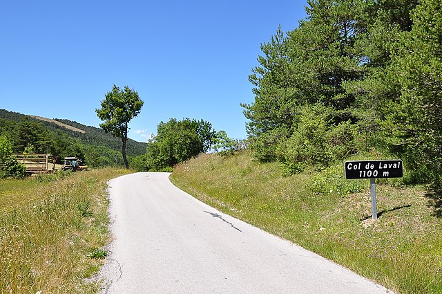
Col de la Loubière: For those looking for a more demanding trek, this trail takes you to higher altitudes and offers breathtaking views.
Preparation Tips:
- Gear: Wear sturdy hiking shoes and dress in layers due to variable weather conditions. A good backpack with water, snacks, and a map is essential.
- Safety: Let someone know your hiking plans, and check local maps or visitor centers for trail conditions before you head out.
- Local Regulations: Respect the natural environment and follow any local regulations or guidelines to protect wildlife and vegetation.
Season:
The best time to hike in Entrevaux is typically in the spring (April to June) and early fall (September to October) when the weather is mild and the landscapes are particularly beautiful.
By choosing to hike in Entrevaux, you're not only treating yourself to beautiful physical surroundings but also a slice of history in a charming French village. Enjoy your hiking adventure!
- Страна:

- Почтовый код: 04320
- Координаты: 43° 56' 55" N, 6° 48' 37" E


- GPS треки (wikiloc): [Ссылка]
- Площадь: 60.37 кв.км
- Население: 877
- Веб сайт: http://www.entrevaux.info/
- Википедия русская: wiki(ru)
- Википедия английская: wiki(en)
- Википедия национальная: wiki(fr)
- Хранилище Wikidata: Wikidata: Q274678
- Катеория в википедии: [Ссылка]
- код Freebase: [/m/08t0my]
- код GeoNames: Альт: [3020119]
- номер SIREN: [210400768]
- код BNF: [12534012w]
- код VIAF: Альт: [167627891]
- код муниципалитета INSEE: 04076
Граничит с регионами:

Сос
- коммуна во Франции
Hiking in Сос
Sausse is a picturesque village located in the Alpes-Maritimes region of France. It offers stunning landscapes, fresh mountain air, and a variety of hiking opportunities suitable for different skill levels. Here are some highlights and tips for hiking in the Sausses area:...
- Страна:
- Почтовый код: 04320
- Координаты: 44° 0' 31" N, 6° 46' 55" E
- GPS треки (wikiloc): [Ссылка]
- Площадь: 14.68 кв.км
- Население: 123

Юбрей
- коммуна во Франции
Hiking in Юбрей
Ubraye is a charming village located in the Alpes-de-Haute-Provence region of France, known for its stunning landscapes, rugged terrain, and beautiful trails. It offers a variety of hiking opportunities suitable for different skill levels and interests. Here’s an overview of what to expect when hiking in Ubraye:...
- Страна:
- Почтовый код: 04240
- Координаты: 43° 54' 31" N, 6° 41' 49" E
- GPS треки (wikiloc): [Ссылка]
- Площадь: 35.65 кв.км
- Население: 88

Сен-Бенуа
Hiking in Сен-Бенуа
Saint-Benoît, located in the Alpes-de-Haute-Provence region of southeastern France, offers an array of hiking opportunities amidst stunning natural scenery. The area is characterized by its picturesque landscapes, which include mountains, valleys, and rivers....
- Страна:
- Почтовый код: 04240
- Координаты: 43° 58' 2" N, 6° 43' 32" E
- GPS треки (wikiloc): [Ссылка]
- Площадь: 21.03 кв.км
- Население: 145

Ла-Рошет
- коммуна во Франции
Hiking in Ла-Рошет
La Rochette is a quaint village located in the Alpes-de-Haute-Provence region of southeastern France. It is surrounded by stunning natural landscapes, making it a great destination for hiking enthusiasts....
- Страна:
- Почтовый код: 06260
- Координаты: 43° 54' 54" N, 6° 53' 26" E
- GPS треки (wikiloc): [Ссылка]
- Площадь: 18.8 кв.км
- Население: 66
Валь-де-Шальвань
- коммуна во Франции
Hiking in Валь-де-Шальвань
Val-de-Chalvagne, located in the Alpes-de-Haute-Provence region of France, offers a variety of beautiful hiking opportunities. The area is characterized by stunning natural landscapes, including scenic valleys, mountains, and rivers, making it a great destination for outdoor enthusiasts....
- Страна:
- Почтовый код: 04320
- Координаты: 43° 54' 51" N, 6° 48' 28" E
- GPS треки (wikiloc): [Ссылка]
- Высота над уровнем моря: 900 м m
- Площадь: 32.57 кв.км
- Население: 88
- Веб сайт: [Ссылка]

Пюже-Тенье
- коммуна в департаменте Приморские Альпы, регион Прованс — Альпы — Лазурный Берег, Франция
Hiking in Пюже-Тенье
Puget-Théniers is a charming commune in the Alpes-Maritimes department in the Provence-Alpes-Côte d’Azur region of southeastern France. Nestled in the stunning landscape of the French Alps, it offers a variety of outdoor activities, including hiking, which can be an incredible way to explore the natural beauty of the area....
- Страна:
- Почтовый код: 06260
- Координаты: 43° 57' 22" N, 6° 53' 37" E
- GPS треки (wikiloc): [Ссылка]
- Площадь: 21.45 кв.км
- Население: 1898
- Веб сайт: [Ссылка]


Ла-Круа-сюр-Рудуль
- коммуна в департаменте Приморские Альпы, регион Прованс — Альпы — Лазурный Берег, Франция
Hiking in Ла-Круа-сюр-Рудуль
La Croix-sur-Roudoule is a charming village located in the Alpes-Maritimes department in the south of France, surrounded by beautiful natural landscapes that offer excellent hiking opportunities. Here are some highlights and tips for hiking in the area:...
- Страна:
- Почтовый код: 06260
- Координаты: 43° 59' 15" N, 6° 52' 30" E
- GPS треки (wikiloc): [Ссылка]
- Площадь: 30.06 кв.км
- Население: 98

Кастелле-ле-Сос
- коммуна во Франции
Hiking in Кастелле-ле-Сос
Castellet-lès-Sausses is a small village located in the Alpes-de-Haute-Provence region of France, and it offers a range of hiking opportunities that showcase the beautiful natural scenery of the area. This region is characterized by its rugged terrain, lush landscapes, and stunning views of the surrounding mountains and valleys....
- Страна:
- Почтовый код: 04320
- Координаты: 43° 59' 40" N, 6° 45' 48" E
- GPS треки (wikiloc): [Ссылка]
- Площадь: 53.91 кв.км
- Население: 132