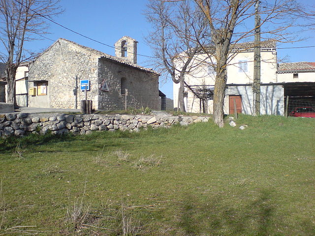
Ла-Рошет (La Rochette, La Rochette)
- коммуна во Франции
 Hiking in Ла-Рошет
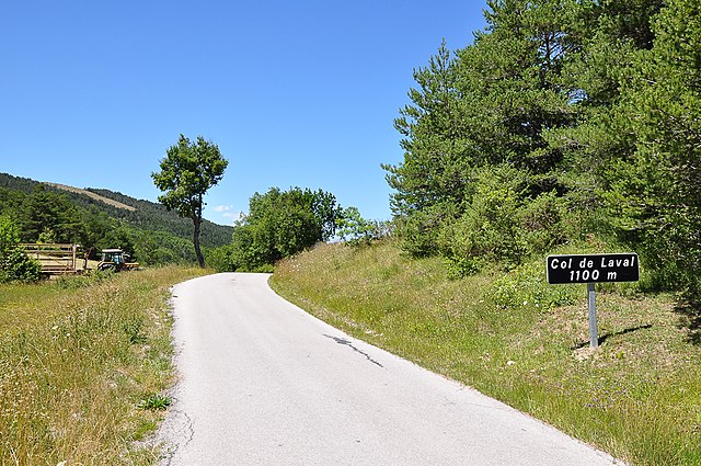
La Rochette is a quaint village located in the Alpes-de-Haute-Provence region of southeastern France. It is surrounded by stunning natural landscapes, making it a great destination for hiking enthusiasts.
Hiking Opportunities:
-
Scenic Trails:
- The area boasts a variety of hiking trails that cater to different skill levels, from easy walks to more challenging hikes. Most trails offer breathtaking views of the mountains, valleys, and the local flora and fauna.
-
Montagne de Lure:
- Just a short distance from La Rochette, you can explore trails in Montagne de Lure, which is known for its diverse ecosystems and panoramic viewpoints. The area is rich in biodiversity, with opportunities to see unique plant species and wildlife.
-
Nature Reserves:
- The nearby Regional Natural Park of Luberon is also accessible, providing extensive trail networks and the chance to immerse yourself in the region's natural beauty.
Tips for Hiking in La Rochette:
-
Trail Maps: It is advisable to carry a detailed trail map or GPS device, as some trails may not be well-marked, especially in remote areas.
-
Local Advice: Consider visiting the local tourist information center for updated trail conditions and recommendations tailored to your interests and capabilities.
-
Weather Awareness: The weather can change quickly in the mountains, so check forecasts and prepare accordingly. Bring layers, as temperatures can vary.
-
Wildlife Considerations: Be aware of local wildlife and practice Leave No Trace principles to preserve the natural environment.
-
Hydration and Nutrition: Carry enough water and snacks, especially for longer hikes, as services may be limited in remote areas.
Conclusion
Hiking in La Rochette and the surrounding Alpes-de-Haute-Provence offers a peaceful escape into nature's beauty. Whether you're looking for a leisurely stroll or a more strenuous trek, the region has something to offer every outdoor enthusiast. Don't forget to take camera gear for capturing the stunning landscapes!
- Страна:

- Почтовый код: 06260
- Координаты: 43° 54' 54" N, 6° 53' 26" E


- GPS треки (wikiloc): [Ссылка]
- Площадь: 18.8 кв.км
- Население: 66
- Википедия русская: wiki(ru)
- Википедия английская: wiki(en)
- Википедия национальная: wiki(fr)
- Хранилище Wikidata: Wikidata: Q1017929
- Катеория в википедии: [Ссылка]
- код Freebase: [/m/03m7_rr]
- код Freebase: [/m/03m7_rr]
- код GeoNames: Альт: [6615711]
- код GeoNames: Альт: [6615711]
- номер SIREN: [210401709]
- номер SIREN: [210401709]
- код муниципалитета INSEE: 04170
- код муниципалитета INSEE: 04170
Граничит с регионами:
Сен-Пьер
- коммуна во Франции
Hiking in Сен-Пьер
Saint-Pierre, located in the Alpes-de-Haute-Provence region of southeastern France, is a fantastic destination for hiking enthusiasts. The surrounding area offers a variety of trails that cater to different skill levels, from leisurely walks to challenging treks....
- Страна:
- Почтовый код: 06260
- Координаты: 43° 54' 43" N, 6° 55' 28" E
- GPS треки (wikiloc): [Ссылка]
- Площадь: 5.62 кв.км
- Население: 97
Валь-де-Шальвань
- коммуна во Франции
Hiking in Валь-де-Шальвань
Val-de-Chalvagne, located in the Alpes-de-Haute-Provence region of France, offers a variety of beautiful hiking opportunities. The area is characterized by stunning natural landscapes, including scenic valleys, mountains, and rivers, making it a great destination for outdoor enthusiasts....
- Страна:
- Почтовый код: 04320
- Координаты: 43° 54' 51" N, 6° 48' 28" E
- GPS треки (wikiloc): [Ссылка]
- Высота над уровнем моря: 900 м m
- Площадь: 32.57 кв.км
- Население: 88
- Веб сайт: [Ссылка]

Амира
- коммуна в департаменте Приморские Альпы, регион Прованс — Альпы — Лазурный Берег, Франция
Hiking in Амира
Amirat, located near Muscat in Oman, is a great destination for hiking enthusiasts. The region is characterized by its stunning mountainous landscapes, traditional Omani villages, and a rich culture. Here are some highlights and tips for hiking in Amirat:...
- Страна:
- Почтовый код: 06910
- Координаты: 43° 53' 26" N, 6° 49' 27" E
- GPS треки (wikiloc): [Ссылка]
- Площадь: 12.95 кв.км
- Население: 74
- Веб сайт: [Ссылка]

Антрево
- коммуна во Франции
Hiking in Антрево
Entrevaux, a picturesque medieval village situated in the Alpes-de-Haute-Provence region of France, offers a unique hiking experience characterized by stunning landscapes, rich history, and well-marked trails. Here are some details about hiking in and around Entrevaux:...
- Страна:
- Почтовый код: 04320
- Координаты: 43° 56' 55" N, 6° 48' 37" E
- GPS треки (wikiloc): [Ссылка]
- Площадь: 60.37 кв.км
- Население: 877
- Веб сайт: [Ссылка]


Коллонг
- коммуна в департаменте Приморские Альпы, регион Прованс — Альпы — Лазурный Берег, Франция
Hiking in Коллонг
Collongues is a charming village located in the Alpes-Maritimes department in the southeastern region of France, nestled within the beautiful landscapes of the French Riviera. Hiking in this area offers a wonderful opportunity to explore the natural beauty and diverse terrain of the region....
- Страна:
- Почтовый код: 06910
- Координаты: 43° 53' 17" N, 6° 51' 47" E
- GPS треки (wikiloc): [Ссылка]
- Площадь: 10.78 кв.км
- Население: 97

Ла-Пен
- коммуна в департаменте Приморские Альпы, регион Прованс — Альпы — Лазурный Берег, Франция
Hiking in Ла-Пен
La Penne is a picturesque village located in the Var department of France, nestled within the stunning landscape of the Provence region. This area offers a variety of hiking opportunities that cater to different skill levels and preferences. Here are some things to know about hiking in La Penne:...
- Страна:
- Почтовый код: 06260
- Координаты: 43° 55' 41" N, 6° 56' 56" E
- GPS треки (wikiloc): [Ссылка]
- Площадь: 18.08 кв.км
- Население: 263


Салагриффон
- коммуна в департаменте Приморские Альпы, регион Прованс — Альпы — Лазурный Берег, Франция
Hiking in Салагриффон
Sallagriffon is not widely recognized as a well-known hiking destination. However, if you meant a specific area or region, I’d be happy to provide information about hiking in that location!...
- Страна:
- Почтовый код: 06910
- Координаты: 43° 53' 0" N, 6° 54' 26" E
- GPS треки (wikiloc): [Ссылка]
- Высота над уровнем моря: 720 м m
- Площадь: 9.59 кв.км
- Население: 45