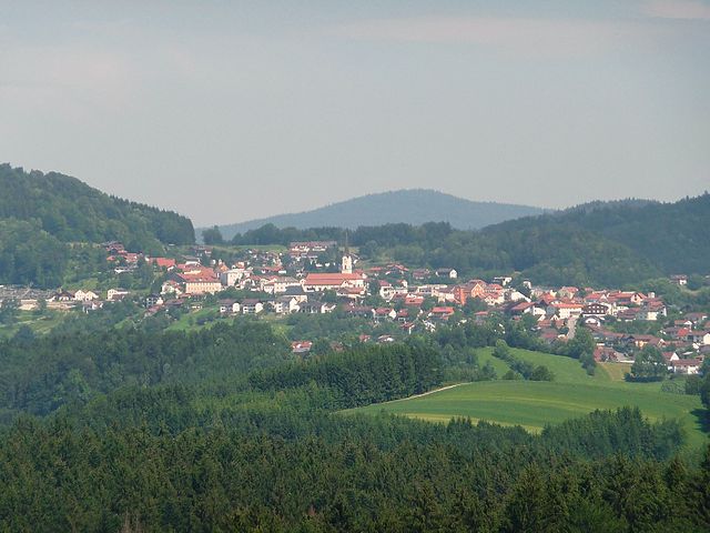
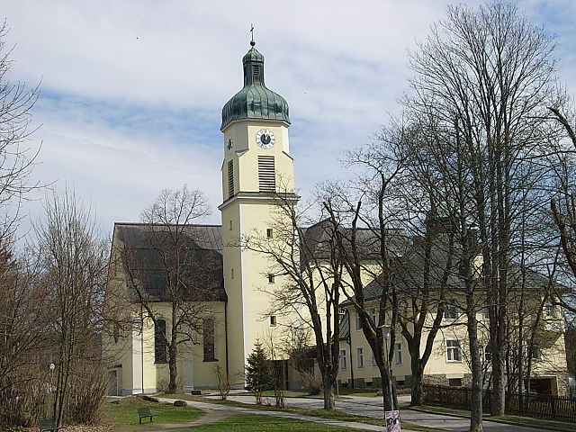
Эппеншлаг (Eppenschlag, Eppenschlag)

 Hiking in Эппеншлаг
Eppenschlag is a charming town located in the Bavaria region of Germany, surrounded by beautiful landscapes that offer a variety of hiking opportunities. Here are some highlights and tips for hiking in and around Eppenschlag:
Hiking Trails
-
Local Trails:
- Eppenschlag has several well-marked trails that traverse the picturesque countryside, forests, and fields. Look for signs that indicate various routes suitable for hikers of different skill levels.
-
Nature Park Trails:
- The region is close to the Bavarian Forest National Park, which provides extensive hiking trails that cater to both beginners and experienced hikers. The trails in the national park feature a mix of terrain, including wooded areas, hills, and scenic viewpoints.
-
The Bavarian Forest:
- Explore the trails leading into the adjacent Bavarian Forest, where you can discover diverse flora and fauna. The forest is known for its rugged terrain and offers opportunities for longer multi-day hikes if you plan to extend your adventure.
-
Circular Routes:
- Many local hiking circles and associations maintain circular routes that start and end in Eppenschlag. These can be a great way to experience the area without the need for transportation.
Tips for Hiking in Eppenschlag
-
Seasonal Considerations: Spring and fall are particularly beautiful times to hike, with vibrant wildflowers and autumn foliage. Summer can be quite warm, while winter offers a different experience if you're prepared for snowshoeing or winter hiking.
-
Equipment: Ensure you have appropriate hiking gear, including sturdy footwear, weather-appropriate clothing, and navigation tools. As trails can sometimes be remote, a good map or GPS device is advisable.
-
Local Amenities: Eppenschlag has options for accommodations, eateries, and local shops, so make sure to check out these spots for a full experience. Pack snacks and hydration for your hikes, but you might find some quaint local cafes along the way.
-
Wildlife Awareness: Keep an eye out for wildlife, including deer and various bird species. Respect their habitat, and follow all guidelines for safely observing wildlife.
-
Hiking Groups: Consider joining a local hiking group or map out group hikes, often posted on community boards or local tourism websites. This can enhance your experience and ensure safety while exploring.
Conclusion
Hiking in Eppenschlag and its surrounding areas is an excellent way to immerse yourself in the natural beauty of Bavaria. Be sure to plan ahead, stay safe, and enjoy the wonderful experience of exploring this idyllic part of Germany!
- Страна:

- Почтовый код: 94536
- Телефонный код: 09928
- Код автомобильного номера: FRG
- Координаты: 48° 53' 0" N, 13° 18' 0" E


- GPS треки (wikiloc): [Ссылка]
- Высота над уровнем моря: 608 м m
- Площадь: 17.03 кв.км
- Население: 890
- Веб сайт: http://www.eppenschlag.de/
- Википедия русская: wiki(ru)
- Википедия английская: wiki(en)
- Википедия национальная: wiki(de)
- Хранилище Wikidata: Wikidata: Q502717
- Катеория в википедии: [Ссылка]
- код Freebase: [/m/02q3699]
- код GeoNames: Альт: [2929840]
- код VIAF: Альт: [247307647]
- ID отношения в OpenStreetMap: [958972]
- код GND: Альт: [4285714-4]
- идентификатор местоположения ArchINFORM: [42810]
- Bavarikon ID: [ODB_A00001459]
- идентификатор муниципалитетов в Германии: 09272116
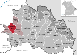
Граничит с регионами:

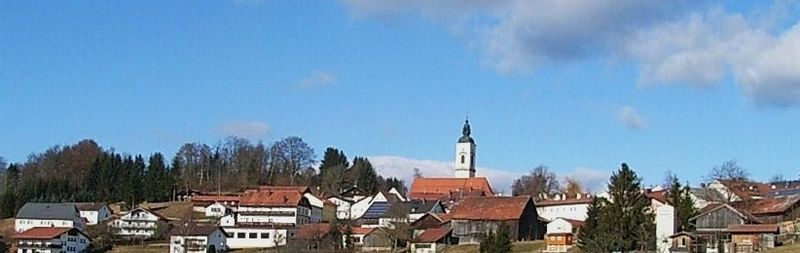
Шёнберг
- муниципалитет в Германии, Бавария
Hiking in Шёнберг
Schönberg, located in Lower Bavaria, is a picturesque area known for its stunning natural landscapes and hiking opportunities. Here are some key features of hiking in this region:...
- Страна:
- Почтовый код: 94513
- Телефонный код: 08554
- Код автомобильного номера: FRG
- Координаты: 48° 50' 0" N, 13° 20' 0" E
- GPS треки (wikiloc): [Ссылка]
- Высота над уровнем моря: 563 м m
- Площадь: 32.75 кв.км
- Население: 3663
- Веб сайт: [Ссылка]

Кирхдорф-им-Вальд
Hiking in Кирхдорф-им-Вальд
Kirchdorf im Wald is a charming village located in the Bavarian region of Germany, known for its beautiful natural landscapes and outdoor activities, particularly hiking. The area offers a variety of hiking trails suitable for different skill levels, making it a great destination for both novice and experienced hikers....
- Страна:
- Почтовый код: 94261
- Телефонный код: 09928
- Код автомобильного номера: REG
- Координаты: 48° 55' 0" N, 13° 16' 0" E
- GPS треки (wikiloc): [Ссылка]
- Высота над уровнем моря: 684 м m
- Площадь: 30.55 кв.км
- Население: 2054
- Веб сайт: [Ссылка]

Иннернцелль
Hiking in Иннернцелль
Innernzell is a charming village located in Bavaria, Germany, known for its beautiful landscapes and outdoor recreational opportunities. Situated near the foothills of the Bavarian Forest, it's an excellent starting point for various hiking adventures....
- Страна:
- Почтовый код: 94548
- Телефонный код: 08554
- Код автомобильного номера: FRG
- Координаты: 48° 51' 0" N, 13° 16' 0" E
- GPS треки (wikiloc): [Ссылка]
- Высота над уровнем моря: 636 м m
- Площадь: 22.12 кв.км
- Население: 1542
- Веб сайт: [Ссылка]

Шпигелау
Hiking in Шпигелау
Spiegelau, located in the Bavarian Forest National Park in Germany, is an excellent destination for hiking enthusiasts. The area is characterized by its beautiful landscapes, dense forests, and a variety of trails catering to different skill levels. Here’s what you can expect when hiking in and around Spiegelau:...
- Страна:
- Почтовый код: 94518
- Телефонный код: 08553
- Код автомобильного номера: FRG
- Координаты: 48° 55' 0" N, 13° 22' 0" E
- GPS треки (wikiloc): [Ссылка]
- Высота над уровнем моря: 759 м m
- Площадь: 47.03 кв.км
- Население: 4064
- Веб сайт: [Ссылка]