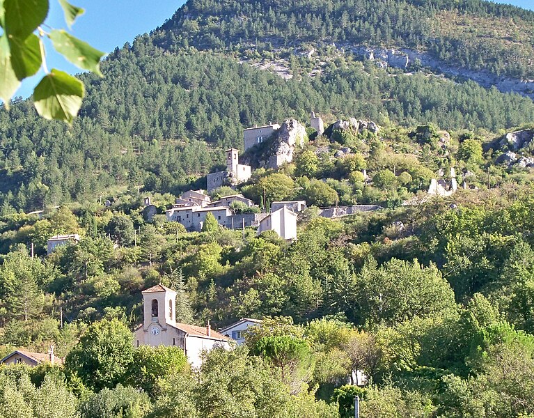
Eyroles (Eyroles)

- коммуна во Франции
 Hiking in Eyroles
Eyroles is a picturesque area located in the southern part of France, known for its stunning landscapes and varied hiking opportunities. While it may not be as famous as some other regions in France, it offers charming trails suitable for all levels of hikers.
Hiking Opportunities in Eyroles:
-
Scenic Trails: Eyroles is surrounded by beautiful forests, rolling hills, and scenic viewpoints. The trails often meander through lush natural surroundings, providing hikers with opportunities to enjoy local flora and fauna.
-
Difficulty Levels: There are trails suitable for beginners, with gentle slopes and well-marked paths, as well as more challenging routes for experienced hikers that may include elevation gains and rugged terrain.
-
Local Flora and Fauna: As you hike, you may encounter diverse plant life, including native shrubs and wildflowers. Wildlife sightings can include birds, deer, and other small mammals.
-
Cultural Landmarks: Some trails may lead to historical sites or viewpoints that overlook charming villages or valleys, allowing hikers to appreciate the local culture alongside the natural beauty.
-
Weather Considerations: The weather can vary, so it's essential to check forecasts before you set out. Spring and autumn can offer pleasant temperatures, while summer can get quite warm, making early morning hikes ideal.
-
Safety Tips: Always carry plenty of water, wear appropriate footwear, and let someone know your hiking plans. It’s advisable to have a map or GPS device, as some trails may not be extensively marked.
-
Guided Tours and Local Knowledge: If you're unfamiliar with the area, consider joining a guided hiking tour. Local guides can offer insights into the environment, history, and culture of Eyroles.
Conclusion
Hiking in Eyroles offers an opportunity to experience the natural beauty and tranquility of the French countryside. Whether you're a seasoned hiker or just looking to enjoy a leisurely walk, Eyroles has something to offer everyone. Always be prepared, respect the environment, and enjoy your adventure!
- Страна:

- Почтовый код: 26110
- Координаты: 44° 25' 2" N, 5° 13' 36" E


- GPS треки (wikiloc): [Ссылка]
- Площадь: 8.75 кв.км
- Население: 33
- Википедия английская: wiki(en)
- Википедия национальная: wiki(fr)
- Хранилище Wikidata: Wikidata: Q860111
- Катеория в википедии: [Ссылка]
- код Freebase: [/m/03mhgbt]
- код GeoNames: Альт: [6430090]
- номер SIREN: [212601306]
- код BNF: [15252991b]
- код муниципалитета INSEE: 26130
Граничит с регионами:

Sahune
- коммуна во Франции
Hiking in Sahune
Sahune is a charming village located in the Drôme department of the Auvergne-Rhône-Alpes region in southeastern France. It's known for its beautiful landscapes, rolling hills, and proximity to the Vercors Regional Natural Park, making it a great base for hiking enthusiasts....
- Страна:
- Почтовый код: 26510
- Координаты: 44° 24' 53" N, 5° 16' 2" E
- GPS треки (wikiloc): [Ссылка]
- Площадь: 16.55 кв.км
- Население: 312


Villeperdrix
- коммуна во Франции
Hiking in Villeperdrix
Villeperdrix is a charming village located in the southern part of France, in the Drôme department within the Auvergne-Rhône-Alpes region. Nestled in the foothills of the Vercors mountain range, it offers stunning landscapes and excellent hiking opportunities for outdoor enthusiasts....
- Страна:
- Почтовый код: 26510
- Координаты: 44° 26' 31" N, 5° 17' 17" E
- GPS треки (wikiloc): [Ссылка]
- Площадь: 26.15 кв.км
- Население: 116
- Веб сайт: [Ссылка]


Curnier
- коммуна во Франции
Hiking in Curnier
Curnier is a picturesque village located in the Jura Mountains of Switzerland. This region is known for its stunning landscapes, rich biodiversity, and well-marked hiking trails that cater to various skill levels. Here’s what you can expect when hiking in and around Curnier:...
- Страна:
- Почтовый код: 26110
- Координаты: 44° 23' 6" N, 5° 14' 4" E
- GPS треки (wikiloc): [Ссылка]
- Площадь: 8 кв.км
- Население: 177

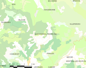
Saint-Ferréol-Trente-Pas
- коммуна во Франции
Hiking in Saint-Ferréol-Trente-Pas
Saint-Ferréol-Trente-Pas is located in the beautiful region of Occitanie in France, nestled in the foothills of the Pyrenees. The area offers a variety of hiking opportunities for both beginners and experienced hikers. Here's what you can expect when hiking in and around Saint-Ferréol-Trente-Pas:...
- Страна:
- Почтовый код: 26110
- Координаты: 44° 25' 37" N, 5° 13' 3" E
- GPS треки (wikiloc): [Ссылка]
- Площадь: 21.48 кв.км
- Население: 236


Les Pilles
- коммуна во Франции
Hiking in Les Pilles
Les Pilles is a beautiful area located in the Vaucluse region of France, known for its stunning natural landscapes and varied hiking opportunities. Here are some key points to consider when planning a hiking trip in Les Pilles:...
- Страна:
- Почтовый код: 26110
- Координаты: 44° 22' 46" N, 5° 11' 26" E
- GPS треки (wikiloc): [Ссылка]
- Площадь: 5.84 кв.км
- Население: 246
Condorcet
- коммуна во Франции
Hiking in Condorcet
Condorcet, located in the Drôme department of France, offers a beautiful setting for hiking enthusiasts. This charming village is surrounded by stunning natural landscapes, including rolling hills, vineyards, and the dramatic backdrop of the Vercors Mountains. Here’s what you can expect when exploring the hiking opportunities in and around Condorcet:...
- Страна:
- Почтовый код: 26110
- Координаты: 44° 24' 28" N, 5° 12' 1" E
- GPS треки (wikiloc): [Ссылка]
- Площадь: 22.44 кв.км
- Население: 474
- Веб сайт: [Ссылка]