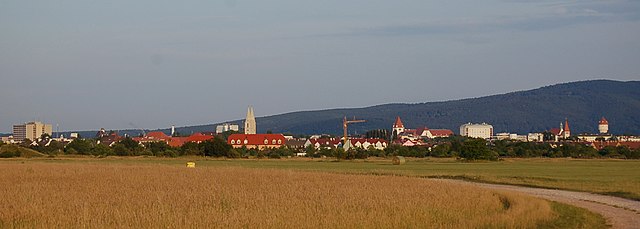
Феликсдорф (Felixdorf, Felixdorf)
- коммуна в Австрии
 Hiking in Феликсдорф
Felixdorf, located in Lower Austria, is a charming area that provides a variety of hiking opportunities, appealing to both novice and seasoned hikers. Nestled near the foothills of the Vienna Woods, this region boasts beautiful landscapes, forests, and scenic trails that are perfect for outdoor enthusiasts.
Hiking Trails:
- Local Trails: There are several marked trails around Felixdorf that range in difficulty. Many of these trails are suitable for families and offer a pleasant experience through scenic wooded areas and fields.
- Vienna Woods Trails: The nearby Vienna Woods (Wienerwald) offers a more extensive network of hiking paths. Here you can find routes that take you through lush forests, past tranquil streams, and up to panoramic viewpoints.
- Long-Distance Trails: For those looking for a challenge, long-distance trails such as the Wienerwaldweg can be accessed from Felixdorf, offering a more comprehensive exploration of the region.
Scenic Highlights:
- Natural Beauty: You'll encounter diverse flora and fauna, beautiful meadows, and quaint villages along the way. The mix of forested areas and open fields makes for a picturesque hiking environment.
- Views: Some trails offer stunning views over the surrounding valleys and the nearby hills, particularly as you gain elevation.
- Cultural Sites: The area is also rich in history, with potential for cultural excursions, such as visiting local churches or historic buildings along the hiking routes.
Tips for Hiking in Felixdorf:
- Best Time to Hike: Spring and autumn are ideal for hiking due to the mild weather and stunning fall colors. Summer can be warm, but the forests offer shade.
- Preparation: Make sure to bring plenty of water, snacks, and a map or GPS device, especially if venturing into less marked trails.
- Safety: Check the weather before your hike and dress appropriately. Wear sturdy hiking boots, and follow local guidelines for safe hiking practices.
In summary, Felixdorf and its surroundings offer a wonderful mix of hiking trails for all levels, along with beautiful scenery and opportunities to explore the cultural heritage of Lower Austria. Enjoy your hike!
- Страна:

- Почтовый код: 2603
- Телефонный код: 02628
- Код автомобильного номера: WB
- Координаты: 47° 53' 0" N, 16° 14' 0" E


- GPS треки (wikiloc): [Ссылка]
- Высота над уровнем моря: 282 м m
- Площадь: 2.54 кв.км
- Население: 4292
- Веб сайт: http://www.felixdorf.gv.at/
- Википедия русская: wiki(ru)
- Википедия английская: wiki(en)
- Википедия национальная: wiki(de)
- Хранилище Wikidata: Wikidata: Q665256
- Катеория в википедии: [Ссылка]
- код Freebase: [/m/03gsbw6]
- код GeoNames: Альт: [7871929]
- код VIAF: Альт: [240948733]
- код GND: Альт: [4305599-0]
- идентификатор местоположения ArchINFORM: [6415]
- код австрийского муниципалитета: [32307]
Граничит с регионами:

Винер-Нойштадт
Hiking in Винер-Нойштадт
Wiener Neustadt, located in Lower Austria, offers several hiking opportunities for outdoor enthusiasts. The region is characterized by a mix of stunning natural landscapes, historical sites, and diverse trails suitable for various skill levels. Here are some highlights and tips for hiking in Wiener Neustadt:...
- Страна:
- Почтовый код: 2700
- Телефонный код: 02622
- Код автомобильного номера: WN
- Координаты: 47° 49' 0" N, 16° 15' 0" E
- GPS треки (wikiloc): [Ссылка]
- Высота над уровнем моря: 265 м m
- Площадь: 60.94 кв.км
- Население: 44461
- Веб сайт: [Ссылка]

Золленау
Hiking in Золленау
Sollenau, located in the picturesque Lower Austria region, offers a variety of hiking opportunities suitable for different skill levels. While it's a smaller town, its surrounding landscapes feature gentle hills, lush forests, and beautiful farmland, providing a serene backdrop for outdoor activities....
- Страна:
- Телефонный код: 02628
- Код автомобильного номера: WB
- Координаты: 47° 54' 0" N, 16° 15' 0" E
- GPS треки (wikiloc): [Ссылка]
- Высота над уровнем моря: 277 м m
- Площадь: 10.67 кв.км
- Население: 5038
- Веб сайт: [Ссылка]
Вёллерсдорф-Штайнабрюкль
Hiking in Вёллерсдорф-Штайнабрюкль
Wöllersdorf-Steinabrückl, located in Austria, offers some beautiful hiking opportunities, especially for those who appreciate natural landscapes and a touch of local history. This area is characterized by its rolling hills, lush forests, and picturesque villages....
- Страна:
- Код автомобильного номера: WB
- Координаты: 47° 52' 0" N, 16° 10' 0" E
- GPS треки (wikiloc): [Ссылка]
- Высота над уровнем моря: 315 м m
- Площадь: 14.53 кв.км
- Население: 4473
- Веб сайт: [Ссылка]

Матцендорф-Хёллес
Hiking in Матцендорф-Хёллес
Matzendorf-Hölles is located in the beautiful state of Lower Austria, Austria. This area is known for its picturesque landscapes and offers various outdoor activities, including hiking. Here are some important points to consider when hiking in and around Matzendorf-Hölles:...
- Страна:
- Телефонный код: 02628
- Код автомобильного номера: WB
- Координаты: 47° 53' 0" N, 16° 13' 0" E
- GPS треки (wikiloc): [Ссылка]
- Высота над уровнем моря: 287 м m
- Площадь: 14.07 кв.км
- Население: 2040
- Веб сайт: [Ссылка]

Терезинфельд
- ярмарочная коммуна в Австрии
Hiking in Терезинфельд
Theresienfeld, located in Lower Austria, is a lesser-known destination for hiking enthusiasts, but it offers a charming landscape and opportunities for exploration. The area is characterized by rolling hills, lush forests, and agricultural fields, making it suitable for various hiking routes....
- Страна:
- Почтовый код: 2604
- Телефонный код: 02622
- Код автомобильного номера: WB
- Координаты: 47° 51' 0" N, 16° 13' 0" E
- GPS треки (wikiloc): [Ссылка]
- Высота над уровнем моря: 282 м m
- Площадь: 11.42 кв.км
- Население: 3485
- Веб сайт: [Ссылка]

Эггендорф
Hiking in Эггендорф
Eggendorf, located in Lower Austria, is surrounded by picturesque landscapes that offer a range of hiking opportunities. The region is characterized by its rolling hills, lush forests, and scenic views, making it an excellent destination for outdoor enthusiasts....
- Страна:
- Телефонный код: 02622
- Код автомобильного номера: WB
- Координаты: 47° 51' 24" N, 16° 19' 40" E
- GPS треки (wikiloc): [Ссылка]
- Высота над уровнем моря: 241 м m
- Площадь: 20.59 кв.км
- Население: 4794
- Веб сайт: [Ссылка]