Флавиль (Flawil, Flawil)

 Hiking in Флавиль
Flawil, located in the canton of St. Gallen, Switzerland, offers pretty scenic hiking opportunities that appeal to both novice and experienced hikers. The region is characterized by its beautiful landscapes, forests, and charming villages, making it a lovely destination for outdoor enthusiasts.
Hiking Opportunities in Flawil
-
Flawil to Staad Hiking Trail: This popular route takes you through picturesque countryside, offering panoramic views of the surrounding hills and valleys. It's a fairly easy hike, perfect for families.
-
Langenhard Nature Reserve: This area features various trails that meander through natural landscapes, with opportunities to observe local wildlife and plant species. It's great for those looking for a peaceful hike.
-
Trail Up the Rosenberg: For a more challenging hike, you can consider the trail that leads up to the Rosenberg. This hike offers stunning views of the region and a chance to explore the higher elevations.
-
Regional Trails: Flawil is part of a broader network of hiking paths throughout the St. Gallen region. You can connect to longer trails that lead to nearby towns and attractions.
Things to Keep in Mind
-
Trail Markings: In Switzerland, trails are well-marked with signs featuring yellow hiking symbols. Be sure to carry a map or have a hiking app handy, especially on less-traveled paths.
-
Weather: Always check the weather before heading out. Conditions in the mountains can change quickly, and it's essential to be prepared with appropriate gear.
-
Footwear: Wear sturdy hiking boots for comfort and support, as some trails may be uneven or steep.
-
Safety: While hiking is generally safe, it's important to stay on marked paths and inform someone about your hiking plans if you’re heading out alone.
-
Nature Conservation: Respect the natural environment by sticking to marked trails and not disturbing wildlife.
Flawil is also conveniently located near other beautiful hiking areas in St. Gallen, allowing for exploration beyond Flawil itself. Depending on your interest and skill level, there are plenty of opportunities to enjoy the stunning Swiss nature!
- Страна:

- Почтовый код: 9230
- Телефонный код: 071
- Код автомобильного номера: SG
- Координаты: 47° 24' 19" N, 9° 11' 52" E


- GPS треки (wikiloc): [Ссылка]
- Высота над уровнем моря: 684 м m
- Площадь: 11.51 кв.км
- Население: 10551
- Веб сайт: http://www.flawil.ch
- Википедия русская: wiki(ru)
- Википедия английская: wiki(en)
- Википедия национальная: wiki(de)
- Хранилище Wikidata: Wikidata: Q65506
- Катеория в википедии: [Ссылка]
- код Freebase: [/m/0gnssl]
- код GeoNames: Альт: [7285837]
- код VIAF: Альт: [135023707]
- ID отношения в OpenStreetMap: [1683879]
- идентификатор местоположения ArchINFORM: [5530]
- код LCNAF: Альт: [n94036465]
- идентификатор HDS: [1393]
- код швейцарского муниципалитета: [3402]
Граничит с регионами:


Херизау
Hiking in Херизау
Herisau is a charming village located in the Appenzell region of Switzerland, surrounded by picturesque landscapes and rolling hills. It's an excellent destination for hiking enthusiasts, offering a variety of trails suitable for different skill levels. Here are some highlights of hiking in Herisau:...
- Страна:
- Почтовый код: 9100
- Телефонный код: 071
- Код автомобильного номера: AR
- Координаты: 47° 23' 6" N, 9° 16' 43" E
- GPS треки (wikiloc): [Ссылка]
- Высота над уровнем моря: 738 м m
- Площадь: 25.2 кв.км
- Население: 15780
- Веб сайт: [Ссылка]

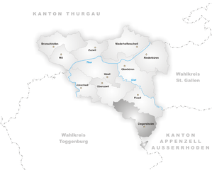
Дегерсхайм
Hiking in Дегерсхайм
Degersheim, located in the Appalachian region of Switzerland, offers several hiking opportunities that cater to all levels of hikers. The area is characterized by its beautiful landscapes, lush forests, rolling hills, and stunning views of the surrounding Alps. Here are some key points to consider when hiking in Degersheim:...
- Страна:
- Почтовый код: 9113
- Телефонный код: 071
- Код автомобильного номера: SG
- Координаты: 47° 22' 0" N, 9° 11' 59" E
- GPS треки (wikiloc): [Ссылка]
- Высота над уровнем моря: 814 м m
- Площадь: 14.48 кв.км
- Население: 4038
- Веб сайт: [Ссылка]


Оберуцвиль
Hiking in Оберуцвиль
Oberuzwil, located in the Canton of St. Gallen in Switzerland, is surrounded by beautiful landscapes and offers various opportunities for hiking enthusiasts. While the town itself is small, it is well-positioned for accessing numerous trails in the surrounding areas....
- Страна:
- Почтовый код: 9604; 9240; 9248; 9242
- Телефонный код: 071
- Код автомобильного номера: SG
- Координаты: 47° 25' 59" N, 9° 8' 0" E
- GPS треки (wikiloc): [Ссылка]
- Высота над уровнем моря: 560 м m
- Площадь: 14.11 кв.км
- Население: 6450
- Веб сайт: [Ссылка]


Обербюрен
Hiking in Обербюрен
Oberbüren is a beautiful small municipality located in the canton of St. Gallen, Switzerland, surrounded by stunning landscapes that are perfect for hiking enthusiasts. The following are some key points to consider when hiking in Oberbüren:...
- Страна:
- Почтовый код: 9245
- Телефонный код: 071
- Код автомобильного номера: SG
- Координаты: 47° 27' 0" N, 9° 9' 59" E
- GPS треки (wikiloc): [Ссылка]
- Высота над уровнем моря: 500 м m
- Площадь: 17.71 кв.км
- Население: 4321
- Веб сайт: [Ссылка]

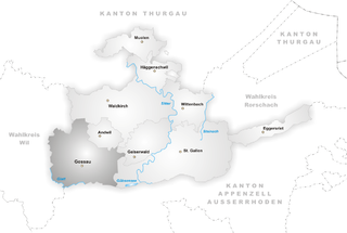
Госсау
Hiking in Госсау
Gossau, located in the canton of St. Gallen in Switzerland, offers fantastic hiking opportunities with stunning views and diverse terrains, making it a great destination for both casual hikers and more experienced outdoor enthusiasts....
- Страна:
- Почтовый код: 9200
- Телефонный код: 071
- Код автомобильного номера: SG
- Координаты: 47° 24' 59" N, 9° 15' 0" E
- GPS треки (wikiloc): [Ссылка]
- Высота над уровнем моря: 638 м m
- Площадь: 27.51 кв.км
- Население: 18171
- Веб сайт: [Ссылка]