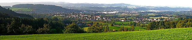
Оберуцвиль (Oberuzwil, Oberuzwil)

 Hiking in Оберуцвиль
Oberuzwil, located in the Canton of St. Gallen in Switzerland, is surrounded by beautiful landscapes and offers various opportunities for hiking enthusiasts. While the town itself is small, it is well-positioned for accessing numerous trails in the surrounding areas.
Hiking Trails
-
Local Trails: There are several local paths around Oberuzwil that cater to different skill levels. These trails often wind through picturesque meadows, forests, and along streams.
-
Uzwil and Beyond: Oberuzwil is close to Uzwil, where you can find more significant hiking routes that lead into the nearby hills and forests, providing beautiful views of the region.
-
Hiking in the Toggenburg Region: A short drive from Oberuzwil leads you to the Toggenburg area, known for its stunning vistas, rolling hills, and well-marked hiking trails. Trails vary from easy walks to more challenging hikes that offer panoramic views of the Alps.
Points of Interest
- Scenic Vistas: As you hike, make sure to take time to enjoy the views of the Swiss countryside and, on clear days, the distant mountains.
- Wildlife: Keep an eye out for local wildlife, as many trails are in areas where you might see deer, birds, and various plant species.
Tips for Hiking in Oberuzwil
- Seasonal Considerations: Swiss weather can be unpredictable, so check the weather forecast before heading out. Most trails are best enjoyed in the spring through autumn months.
- Trail Difficulty: Be sure to select trails that match your fitness level and experience. Maps and local guides can provide valuable information on trail conditions and difficulty.
- Essential Gear: Always wear appropriate footwear, bring sufficient water, and have a map or GPS device handy. A first aid kit is also advisable.
Transportation
- Accessing Trails: Oberuzwil is well-connected by local transport, making it easy to reach trailheads without a car. Check local schedules for buses or trains that head to popular hiking regions.
Overall, Oberuzwil serves as a charming base for hiking enthusiasts looking to explore the natural beauty of Switzerland. Whether you're an experienced hiker or a beginner, there are plenty of trails to discover in and around this delightful town.
- Страна:

- Почтовый код: 9604; 9240; 9248; 9242
- Телефонный код: 071
- Код автомобильного номера: SG
- Координаты: 47° 25' 59" N, 9° 8' 0" E


- GPS треки (wikiloc): [Ссылка]
- Высота над уровнем моря: 560 м m
- Площадь: 14.11 кв.км
- Население: 6450
- Веб сайт: http://www.oberuzwil.ch
- Википедия русская: wiki(ru)
- Википедия английская: wiki(en)
- Википедия национальная: wiki(de)
- Хранилище Wikidata: Wikidata: Q66557
- Катеория в википедии: [Ссылка]
- код Freebase: [/m/071c7b]
- код GeoNames: Альт: [7286718]
- код VIAF: Альт: [248720791]
- ID отношения в OpenStreetMap: [1683918]
- код GND: Альт: [4532031-7]
- идентификатор HDS: [1397]
- код швейцарского муниципалитета: [3407]
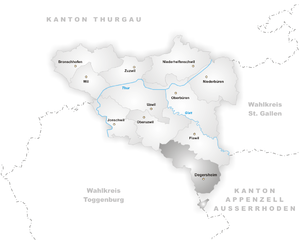
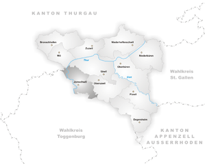
Граничит с регионами:

Уцвиль
Hiking in Уцвиль
Uzwil, located in the canton of St. Gallen in Switzerland, offers various opportunities for hiking enthusiasts. While Uzwil itself is a small town, it is surrounded by beautiful Swiss countryside and hills, providing access to several well-marked hiking trails....
- Страна:
- Почтовый код: 9249; 9247; 9244; 9240
- Телефонный код: 071
- Код автомобильного номера: SG
- Координаты: 47° 27' 0" N, 9° 8' 0" E
- GPS треки (wikiloc): [Ссылка]
- Высота над уровнем моря: 545 м m
- Площадь: 14.49 кв.км
- Население: 12849
- Веб сайт: [Ссылка]

Дегерсхайм
Hiking in Дегерсхайм
Degersheim, located in the Appalachian region of Switzerland, offers several hiking opportunities that cater to all levels of hikers. The area is characterized by its beautiful landscapes, lush forests, rolling hills, and stunning views of the surrounding Alps. Here are some key points to consider when hiking in Degersheim:...
- Страна:
- Почтовый код: 9113
- Телефонный код: 071
- Код автомобильного номера: SG
- Координаты: 47° 22' 0" N, 9° 11' 59" E
- GPS треки (wikiloc): [Ссылка]
- Высота над уровнем моря: 814 м m
- Площадь: 14.48 кв.км
- Население: 4038
- Веб сайт: [Ссылка]


Флавиль
Hiking in Флавиль
Flawil, located in the canton of St. Gallen, Switzerland, offers pretty scenic hiking opportunities that appeal to both novice and experienced hikers. The region is characterized by its beautiful landscapes, forests, and charming villages, making it a lovely destination for outdoor enthusiasts....
- Страна:
- Почтовый код: 9230
- Телефонный код: 071
- Код автомобильного номера: SG
- Координаты: 47° 24' 19" N, 9° 11' 52" E
- GPS треки (wikiloc): [Ссылка]
- Высота над уровнем моря: 684 м m
- Площадь: 11.51 кв.км
- Население: 10551
- Веб сайт: [Ссылка]

Йоншвиль
Hiking in Йоншвиль
Jonschwil is a picturesque area in Switzerland, located in the canton of St. Gallen. It offers a range of hiking opportunities, allowing both novice and experienced hikers to enjoy the beautiful Swiss landscape. Here are some highlights and tips for hiking in Jonschwil:...
- Страна:
- Почтовый код: 9243
- Телефонный код: 071
- Код автомобильного номера: SG
- Координаты: 47° 25' 42" N, 9° 5' 19" E
- GPS треки (wikiloc): [Ссылка]
- Высота над уровнем моря: 586 м m
- Площадь: 10.99 кв.км
- Население: 3801
- Веб сайт: [Ссылка]


Обербюрен
Hiking in Обербюрен
Oberbüren is a beautiful small municipality located in the canton of St. Gallen, Switzerland, surrounded by stunning landscapes that are perfect for hiking enthusiasts. The following are some key points to consider when hiking in Oberbüren:...
- Страна:
- Почтовый код: 9245
- Телефонный код: 071
- Код автомобильного номера: SG
- Координаты: 47° 27' 0" N, 9° 9' 59" E
- GPS треки (wikiloc): [Ссылка]
- Высота над уровнем моря: 500 м m
- Площадь: 17.71 кв.км
- Население: 4321
- Веб сайт: [Ссылка]


Лютисбург
Hiking in Лютисбург
Lütisburg is a charming area located in the canton of St. Gallen, Switzerland, known for its beautiful landscapes, rolling hills, and scenic trails. Hiking in Lütisburg offers a unique experience with a mix of nature, tranquility, and stunning views of the surrounding countryside and the Alps....
- Страна:
- Почтовый код: 9604
- Телефонный код: 071
- Код автомобильного номера: SG
- Координаты: 47° 23' 41" N, 9° 4' 52" E
- GPS треки (wikiloc): [Ссылка]
- Высота над уровнем моря: 580 м m
- Площадь: 14.09 кв.км
- Население: 1565
- Веб сайт: [Ссылка]