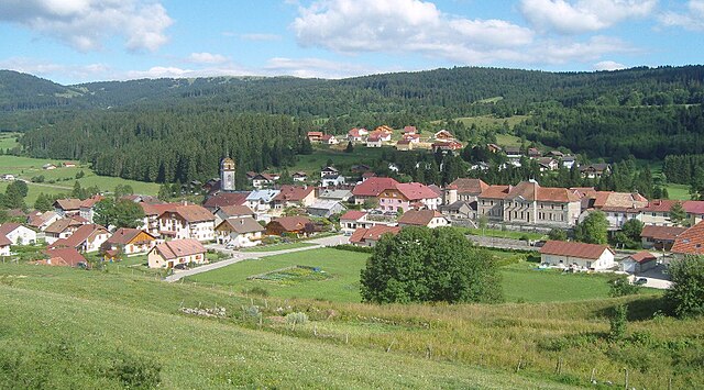
Fourcatier-et-Maison-Neuve (Fourcatier-et-Maison-Neuve)

- коммуна во Франции
 Hiking in Fourcatier-et-Maison-Neuve
Fourcatier-et-Maison-Neuve is a small commune located in the Jura department of France, an area that offers beautiful landscapes and opportunities for outdoor activities, including hiking. The Jura mountains are known for their rugged terrain, dense forests, and picturesque views, making them a great destination for nature enthusiasts.
Hiking Opportunities:
-
Scenic Trails: The Jura region features a variety of trails that cater to different skill levels, from easy walks to more challenging hikes. You can expect to encounter well-marked paths through forests and along ridges that provide stunning panoramas.
-
Flora and Fauna: Hiking in this area allows you to experience a rich diversity of local flora and fauna. Keep an eye out for various plant species, wildlife, and perhaps even some unique geological formations.
-
Local Guides and Maps: It might be beneficial to consult local hiking guides or visitor centers for the latest trail maps and conditions. They can also help you find trails that match your experience level and interests.
-
Historical Sites: Some trails may lead to historical landmarks and sites of interest, giving you an opportunity to blend hiking with cultural exploration.
-
Seasonal Considerations: The best times for hiking in the Jura are typically late spring through early fall. Winter months can bring snow, which can limit certain trails but may also offer opportunities for snowshoeing and other winter sports.
Preparation Tips:
-
Gear: Make sure to wear appropriate hiking boots and clothing suited for the weather. A good backpack with water, snacks, and a first-aid kit is essential.
-
Navigation: Carry a map or have a reliable GPS device, as some trails may not be as well-marked as others.
-
Respect Nature: Follow Leave No Trace principles to ensure that the beautiful landscapes remain pristine for future hikers.
Overall, Fourcatier-et-Maison-Neuve and the surrounding Jura mountains offer wonderful hiking experiences for those looking to explore the great outdoors in France. Whether you are a seasoned hiker or just starting out, there are trails to suit your needs!
- Страна:

- Почтовый код: 25370
- Координаты: 46° 45' 45" N, 6° 19' 4" E


- GPS треки (wikiloc): [Ссылка]
- Площадь: 2.75 кв.км
- Население: 103
- Википедия английская: wiki(en)
- Википедия национальная: wiki(fr)
- Хранилище Wikidata: Wikidata: Q839957
- Катеория в википедии: [Ссылка]
- код Freebase: [/m/03mh8f9]
- код Freebase: [/m/03mh8f9]
- код GeoNames: Альт: [6616217]
- код GeoNames: Альт: [6616217]
- номер SIREN: [212502520]
- номер SIREN: [212502520]
- код BNF: [15252478r]
- код BNF: [15252478r]
- код муниципалитета INSEE: 25252
- код муниципалитета INSEE: 25252
Граничит с регионами:

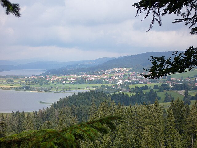
Rochejean
- коммуна во Франции
Hiking in Rochejean
Rochejean, located in the Jura mountains of France, is a beautiful destination for hiking enthusiasts. Known for its stunning landscapes, lush forests, and diverse wildlife, Rochejean offers a range of trails suitable for various skill levels....
- Страна:
- Почтовый код: 25370
- Координаты: 46° 44' 44" N, 6° 17' 37" E
- GPS треки (wikiloc): [Ссылка]
- Площадь: 24.32 кв.км
- Население: 680


Saint-Antoine
Hiking in Saint-Antoine
Saint-Antoine, located in the Doubs department of the Bourgogne-Franche-Comté region in eastern France, is an excellent destination for hiking enthusiasts. This area is characterized by stunning natural landscapes, including forests, rolling hills, and picturesque views of the surrounding countryside....
- Страна:
- Почтовый код: 25370
- Координаты: 46° 46' 37" N, 6° 20' 16" E
- GPS треки (wikiloc): [Ссылка]
- Площадь: 4.51 кв.км
- Население: 336

Labergement-Sainte-Marie
- коммуна во Франции
Hiking in Labergement-Sainte-Marie
Labergement-Sainte-Marie is a charming village located in the Doubs department of the Bourgogne-Franche-Comté region in eastern France. Nestled in the heart of the Jura Mountains, it offers beautiful landscapes, rich flora and fauna, and a variety of hiking opportunities suitable for different skill levels....
- Страна:
- Почтовый код: 25160
- Координаты: 46° 46' 29" N, 6° 16' 50" E
- GPS треки (wikiloc): [Ссылка]
- Площадь: 22.12 кв.км
- Население: 1160