
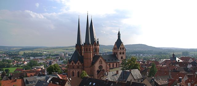
Франкфурт-на-Майне (Frankfurt, Frankfurt am Main)


- город в земле Гессен, Германия
 Hiking in Франкфурт-на-Майне
Hiking in Frankfurt offers a unique blend of urban and natural experiences. While Frankfurt itself is a bustling financial hub, it is also surrounded by beautiful landscapes that are great for outdoor enthusiasts. Here are some key points to consider:
Nearby Hiking Areas
-
Frankfurt Green Belt (Grüner Ring): This 100-km circular route encircles the city and includes parks, forests, and agricultural areas. It’s a great way to explore nature while still being close to the city.
-
Taunus Mountains: Located just north of Frankfurt, the Taunus offers numerous trails with varying difficulties. The region features scenic vistas, charming small towns such as Königstein and Bad Homburg, and historical sites like the Alte Nikolaikirche.
-
Vordertaunus Nature Park: This is a fantastic area for hiking, with trails that provide stunning views of the rolling hills, dense forests, and meadows. Popular hikes include the Limes Trail, which follows the ancient Roman border.
-
Nerotal Park and the Frankfurt City Forest: Closer to the city, this area offers easy trails that are perfect for a leisurely hike. The city forest is one of the largest urban forests in Germany and is ideal for quick getaways.
Trail Recommendations
-
Bergstraße-Odenwald: This region to the south of Frankfurt is known for its vineyards and scenic views. The Bergstraße section includes the Nibelungensteig, a long-distance hiking trail.
-
Main-Weser Trail: This trail runs along the banks of the Main River and provides peaceful views and easy walking suitable for all levels.
Tips for Hiking in Frankfurt
-
Public Transport: Frankfurt’s public transport system is efficient, making it easy to reach hiking spots. Take a train or bus to communities in the surrounding areas where trails and parks are accessible.
-
Seasonal Considerations: Spring and fall offer great weather for hiking, but summer can be hot, so carry enough water and sunscreen. Winter hikes can also be beautiful, but be cautious of icy trails.
-
Hiking Groups: If you prefer to hike with others, consider joining local hiking clubs or groups. They often organize group hikes and events, which can be a great way to meet fellow hikers.
-
Prepare: Always check weather conditions, wear appropriate footwear, and prepare for changing weather. Having a map or a GPS device is also advisable.
Whether you're an experienced hiker or just looking for a pleasant day out, Frankfurt has plenty to offer for those looking to explore the great outdoors.
- Страна:

- Почтовый код: 65929–65936; 60308–60599
- Телефонный код: 069; 6101; 6109
- Код автомобильного номера: F
- Координаты: 50° 6' 49" N, 8° 40' 47" E


- GPS треки (wikiloc): [Ссылка]
- Высота над уровнем моря: 112 м m
- Площадь: 248.31 кв.км
- Население: 736414
- Веб сайт: https://www.frankfurt.de/
- Википедия русская: wiki(ru)
- Википедия английская: wiki(en)
- Википедия национальная: wiki(de)
- Хранилище Wikidata: Wikidata: Q1794
- Галерея изображений в википедии: [Ссылка]
- Катеория в википедии: [Ссылка]
- Карты в википедии: [Ссылка]
- код Freebase: [/m/02z0j]
- код GeoNames: Альт: [2925533]
- код BNF: [11864186q]
- код VIAF: Альт: [151720959]
- ID отношения в OpenStreetMap: [62400]
- код GND: Альт: [4018118-2]
- идентификатор местоположения ArchINFORM: [315]
- код LCNAF: Альт: [n79149017]
- место в MusicBrainz: [16560d3e-358b-4869-8a6d-727db2ee7b69]
- код темы Quora: [Frankfurt-am-Main]
- код TGN: [7005293]
- UN/LOCODE: [DEFRA]
- код SUDOC: [026383993]
- код в энциклопедии «Британника онлайн»: [place/Frankfurt-am-Main]
- код в Encyclopædia Universalis: [francfort-sur-le-main]
- идентификатор HDS: [6588]
- EMLO location ID: [7fd0970e-bae1-4865-bdbf-e993d1bfa883]
- код места в Facebook: [110221372332205]
- учётная запись в Твиттере: Альт: [Stadt_FFM]
- код в Большой российской энциклопедии онлайн: [4735834]
- код ISNI: Альт: [0000 0001 2185 8098]
- код NKC: [ge129155]
- dmoz: Альт: [Regional/Europe/Germany/States/Hesse/Localities/Frankfurt_am_Main/]
- код NLI: [000987470]
- код NUTS: [DE712]
- код YSO: [108246]
- Nomisma ID: [frankfurt_main]
- код статьи Klexikon: [Frankfurt_am_Main]
- код BabelNet: [00036259n]
- сабреддит: [frankfurt]
- код GAMEO: [Frankfurt am Main (Hesse, Germany)]
- учётная запись Facebook: Альт: [StadtFFM]
- STW Thesaurus for Economics ID: [30105-3]
- код места в Foursquare: [4b058853f964a5202dbf22e3]
- учётная запись Google+: [+StadtFFM]
- идентификатор муниципалитетов в Германии: 06412000
- код US National Archives: 10044637
- код района Германии: 06412
Включает регионы:
Инненштадт II
- административный округ Франкфурта-на-Майне
Hiking in Инненштадт II
Frankfurt-Innenstadt II, located in the heart of Frankfurt, Germany, offers a unique urban hiking experience. While it is primarily known for its modern skyline, bustling business districts, and cultural attractions, there are opportunities for enjoyable walks and hikes in and around the area....
- Страна:
- Координаты: 50° 7' 17" N, 8° 38' 42" E
- GPS треки (wikiloc): [Ссылка]
Инненштадт III
- административный округ Франкфурта-на-Майне
Hiking in Инненштадт III
Hiking in the Frankfurt-Innenstadt III area offers a unique opportunity to explore both urban and natural landscapes. While the Innenstadt III is primarily an urban district of Frankfurt, there are several nearby parks and green spaces that provide great hiking opportunities. Here's what you can expect:...
- Страна:
- Координаты: 50° 7' 24" N, 8° 41' 34" E
- GPS треки (wikiloc): [Ссылка]
Инненштадт IV
- административный округ Франкфурта-на-Майне
Hiking in Инненштадт IV
Frankfurt-Bornheim and Ostend are vibrant neighborhoods in Frankfurt, Germany, that offer some interesting opportunities for hiking and outdoor activities, though they are more urban than rural. Here's a general overview of what you might enjoy in these areas:...
- Страна:
- Координаты: 50° 7' 26" N, 8° 42' 48" E
- GPS треки (wikiloc): [Ссылка]
Frankfurt-Mitte-Nord
Hiking in Frankfurt-Mitte-Nord
Frankfurt-Mitte-Nord is an intriguing area for hiking enthusiasts, combining both urban nature experiences and accessibility to surrounding parks and green spaces. While the area itself may not offer extensive hiking trails like more rural locations, there are several nearby options that can enhance your hiking experience:...
- Страна:
- Координаты: 50° 8' 0" N, 8° 40' 0" E
- GPS треки (wikiloc): [Ссылка]
Frankfurt-Mitte-West
Hiking in Frankfurt-Mitte-West
Frankfurt-Mitte-West is situated in the heart of Frankfurt, and while it may not be known as a traditional hiking destination, there are plenty of opportunities for urban hiking and enjoying nature in and around the area. Here are some aspects to consider if you're looking to hike in and around Frankfurt-Mitte-West:...
- Страна:
- Координаты: 50° 8' 3" N, 8° 37' 0" E
- GPS треки (wikiloc): [Ссылка]
Frankfurt-Nord-Ost
Hiking in Frankfurt-Nord-Ost
Frankfurt-Nord-Ost is a great area for hiking, blending urban surroundings with natural landscapes. Here’s what to expect and some tips for hiking in this region:...
- Страна:
- Координаты: 50° 9' 50" N, 8° 41' 17" E
- GPS треки (wikiloc): [Ссылка]
Frankfurt-Nord-West
Hiking in Frankfurt-Nord-West
Frankfurt-Nord-West is not only an urban area but also provides access to various hiking opportunities nearby. The Frankfurt region is characterized by a mix of nature, parks, and access to the scenic beauty of the surrounding countryside. Here are some points to consider if you're hiking in and around Frankfurt-Nord-West:...
- Страна:
- Координаты: 50° 9' 0" N, 8° 38' 0" E
- GPS треки (wikiloc): [Ссылка]
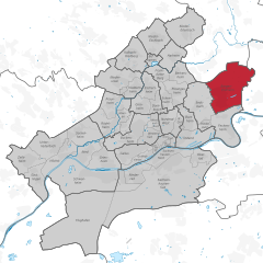
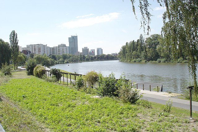
Frankfurt-Ost
Hiking in Frankfurt-Ost
Hiking in Frankfurt-Ost, which is on the eastern side of Frankfurt am Main, offers a mix of urban and natural experiences. While the city itself is known for its skyline and urban landscape, the surrounding areas provide some beautiful hiking opportunities, particularly in the nearby forests and natural reserves....
- Страна:
- Координаты: 50° 8' 6" N, 8° 44' 29" E
- GPS треки (wikiloc): [Ссылка]
Frankfurt-Süd
Hiking in Frankfurt-Süd
Frankfurt-Süd, located in the southern part of Frankfurt, offers a variety of hiking opportunities that cater to different skill levels and preferences. Here are some highlights for hiking in this area:...
- Страна:
- Координаты: 50° 4' 55" N, 8° 40' 20" E
- GPS треки (wikiloc): [Ссылка]
Франкфурт-Вест
Hiking in Франкфурт-Вест
Frankfurt-West offers several options for hiking enthusiasts, with a mix of urban and natural landscapes. While Frankfurt itself is a bustling city, there are nearby parks, forested areas, and trails that provide opportunities for outdoor activities....
- Страна:
- Координаты: 50° 6' 13" N, 8° 33' 19" E
- GPS треки (wikiloc): [Ссылка]

Bergen-Enkheim
Hiking in Bergen-Enkheim
Bergen-Enkheim is a district in Frankfurt, Germany, known for its beautiful landscapes and proximity to nature. While not as famous for hiking as other areas in Germany, there are still some lovely trails and parks in and around Bergen-Enkheim that cater to outdoor enthusiasts....
- Страна:
- Координаты: 50° 9' 18" N, 8° 45' 11" E
- GPS треки (wikiloc): [Ссылка]
- Высота над уровнем моря: 126 м m
- Площадь: 12.541 кв.км
- Население: 17808
Nieder-Eschbach
Hiking in Nieder-Eschbach
Nieder-Eschbach is a district in the northern part of Frankfurt, Germany, known for its scenic trails and proximity to natural landscapes. Here’s what you should know about hiking in this area:...
- Страна:
- Телефонный код: 069
- Координаты: 50° 12' 23" N, 8° 39' 51" E
- GPS треки (wikiloc): [Ссылка]
- Высота над уровнем моря: 139 м m
- Площадь: 6.350 кв.км
- Население: 11572
Нидер-Эрленбах
Hiking in Нидер-Эрленбах
Nieder-Erlenbach is a picturesque district located in the outskirts of Frankfurt, Germany. It is known for its charming rural atmosphere and proximity to various natural landscapes, making it an excellent spot for hiking enthusiasts. Here are some key points to consider when hiking in and around Nieder-Erlenbach:...
- Страна:
- Телефонный код: 06101
- Координаты: 50° 12' 11" N, 8° 42' 0" E
- GPS треки (wikiloc): [Ссылка]
- Площадь: 8.340 кв.км

Harheim
Hiking in Harheim
Harheim is a district located in the city of Frankfurt, Germany, and it offers various opportunities for a lovely hiking experience, particularly in the surrounding areas of forested regions and hills. While Harheim itself may not be a well-known hiking destination, its proximity to larger green spaces and trails makes it a good base for exploring nature....
- Страна:
- Координаты: 50° 11' 1" N, 8° 41' 27" E
- GPS треки (wikiloc): [Ссылка]
- Высота над уровнем моря: 109 м m
- Площадь: 4.841 кв.км
Kalbach-Riedberg
Hiking in Kalbach-Riedberg
Kalbach-Riedberg is a district located in Frankfurt, Germany, known for its blend of urban life and natural spaces. While it may not be as widely recognized for hiking as some other regions, there are still opportunities to explore the local landscapes around the area....
- Страна:
- Телефонный код: 069
- Координаты: 50° 11' 21" N, 8° 38' 22" E
- GPS треки (wikiloc): [Ссылка]
- Площадь: 6.10 кв.км
Инненштадт I
- административный округ Франкфурта-на-Майне
Hiking in Инненштадт I
Frankfurt-Innenstadt, while primarily known as a bustling urban center, offers some unique hiking opportunities and green spaces that allow for a blend of urban exploration and nature....
- Страна:
- Координаты: 50° 6' 14" N, 8° 38' 57" E
- GPS треки (wikiloc): [Ссылка]
Граничит с регионами:


Бад-Фильбель
Hiking in Бад-Фильбель
Bad Vilbel, located in the heart of Hesse, Germany, is surrounded by beautiful nature and offers several hiking opportunities. Nestled near the Nidda River and close to the Frankfurter Wald, hikers can enjoy a mix of scenic views, lush forests, and charming local culture....
- Страна:
- Почтовый код: 61118
- Телефонный код: 06101
- Код автомобильного номера: FB
- Координаты: 50° 10' 39" N, 8° 44' 8" E
- GPS треки (wikiloc): [Ссылка]
- Высота над уровнем моря: 111 м m
- Площадь: 26 кв.км
- Население: 33745
- Веб сайт: [Ссылка]

Оффенбах-на-Майне
- город в Гессене, Германия
Hiking in Оффенбах-на-Майне
Offenbach am Main, located in Hesse, Germany, is not a major hiking destination compared to other regions in Germany, but it offers some pleasant options for outdoor enthusiasts. While the city itself is more urban, there are several nearby areas where you can enjoy hiking and nature....
- Страна:
- Почтовый код: 63075; 63073; 63071; 63069; 63067; 63065
- Телефонный код: 069
- Код автомобильного номера: OF
- Координаты: 50° 6' 0" N, 8° 46' 0" E
- GPS треки (wikiloc): [Ссылка]
- Высота над уровнем моря: 98 м m
- Площадь: 44.89 кв.км
- Население: 124589
- Веб сайт: [Ссылка]

Верхний Таунус
Hiking in Верхний Таунус
Hochtaunuskreis, located in the state of Hesse, Germany, is a fantastic area for hiking enthusiasts. This region is characterized by its rolling hills, dense forests, and stunning vistas, making it a wonderful destination for both casual walkers and experienced hikers. Here are some highlights and tips for hiking in Hochtaunuskreis:...
- Страна:
- Столица: Бад-Хомбург
- Код автомобильного номера: HG
- Координаты: 50° 12' 56" N, 8° 36' 59" E
- GPS треки (wikiloc): [Ссылка]
- Высота над уровнем моря: 385 м m
- Площадь: 482.03 кв.км
- Веб сайт: [Ссылка]


Майн-Таунус
Hiking in Майн-Таунус
Main-Taunus-Kreis, located in Hesse, Germany, is a beautiful area known for its picturesque landscapes, including the Taunus mountains. Hiking in this region can be a rewarding experience, offering a mix of nature, history, and outdoor activities....
- Страна:
- Столица: Хофхайм-ам-Таунус
- Код автомобильного номера: MTK
- Координаты: 50° 4' 46" N, 8° 26' 58" E
- GPS треки (wikiloc): [Ссылка]
- Высота над уровнем моря: 245 м m
- Площадь: 222.40 кв.км
- Население: 226113
- Веб сайт: [Ссылка]

Веттерау
- район в Германии
Hiking in Веттерау
Wetteraukreis, located in the state of Hesse, Germany, offers a diverse range of landscapes and hiking opportunities that cater to outdoor enthusiasts of all levels. With its rolling hills, picturesque villages, lush forests, and scenic meadows, the region provides a delightful backdrop for exploring nature....
- Страна:
- Столица: Фридберг
- Код автомобильного номера: FB
- Координаты: 50° 20' 0" N, 8° 45' 9" E
- GPS треки (wikiloc): [Ссылка]
- Высота над уровнем моря: 137 м m
- Площадь: 1101.71 кв.км
- Веб сайт: [Ссылка]

Майн-Кинциг
Hiking in Майн-Кинциг
Main-Kinzig-Kreis, located in the state of Hesse, Germany, offers a diverse array of hiking opportunities suitable for various skill levels and preferences. The region is characterized by beautiful landscapes, including forests, rivers, hills, and quaint villages, making it a great destination for outdoor enthusiasts. Here are some highlights:...
- Страна:
- Столица: Гельнхаузен
- Код автомобильного номера: MKK
- Координаты: 50° 12' 4" N, 9° 11' 51" E
- GPS треки (wikiloc): [Ссылка]
- Высота над уровнем моря: 202 м m
- Площадь: 1397.52 кв.км
- Население: 407619
- Веб сайт: [Ссылка]
Оффенбах
Hiking in Оффенбах
Offenbach, located in the state of Hesse, Germany, is surrounded by scenic areas that offer a variety of hiking opportunities. Although it is an urban district, its proximity to nature parks and the countryside makes it a great base for hikers....
- Страна:
- Столица: Оффенбах-на-Майне
- Код автомобильного номера: OF
- Координаты: 50° 1' 6" N, 8° 47' 8" E
- GPS треки (wikiloc): [Ссылка]
- Высота над уровнем моря: 143 м m
- Площадь: 356.29 кв.км
- Население: 336265
- Веб сайт: [Ссылка]


Грос-Герау
Hiking in Грос-Герау
Groß-Gerau is a district in the state of Hesse, Germany, located just south of Frankfurt. While it may not be as well-known for hiking as some other regions in Germany, it offers a variety of scenic routes that showcase the natural beauty of the area....
- Страна:
- Столица: Грос-Герау
- Код автомобильного номера: GG
- Координаты: 49° 54' 46" N, 8° 28' 42" E
- GPS треки (wikiloc): [Ссылка]
- Высота над уровнем моря: 87 м m
- Площадь: 453.05 кв.км
- Население: 254883
- Веб сайт: [Ссылка]