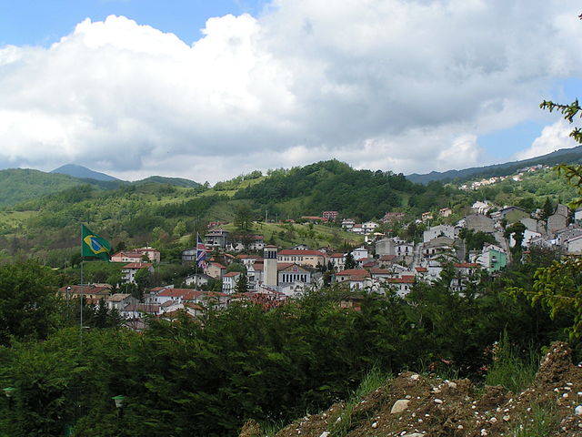
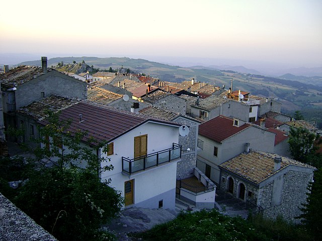
Гамберале (Gamberale, Gamberale)
.svg)
- коммуна Италии
 Hiking in Гамберале
Gamberale, a charming village located in the Abruzzo region of Italy, offers a fantastic hiking experience surrounded by stunning natural landscapes. The area is characterized by mountainous terrain, lush forests, and picturesque views, making it an excellent destination for outdoor enthusiasts.
Hiking Trails in Gamberale
-
Parco Nazionale della Majella: Gamberale is situated near the Majella National Park, which boasts numerous hiking trails. Trails vary in difficulty, catering to both beginners and experienced hikers. Popular routes include the path leading to the Torre di Cerrano, which offers breathtaking views of the surrounding valleys.
-
Monte Amaro: For those seeking a challenge, the trek up Monte Amaro, the second highest peak in the Apennines, is a rewarding experience. The trail is steep, but the panoramic vistas from the summit are worth the effort.
-
The Valley of the Orfento: This path offers a beautiful trek along the Orfento River with waterfalls and lush vegetation. It's a great trail for those who enjoy scenic views and tranquil nature.
-
Historical Trails: Gamberale is also rich in history. Trails that take you to ancient hermitages and ruins, such as the Eremo di San Bartolomeo, provide an immersive experience into the local culture and history.
Tips for Hiking in Gamberale
- Weather: Always check the weather conditions before heading out, as mountain weather can change rapidly.
- Preparation: Bring plenty of water, snacks, and a first aid kit. Wear suitable hiking boots and clothing layers to adapt to changing temperatures.
- Stay on Trails: To preserve the natural landscape, always stick to marked trails and respect local wildlife.
- Local Regulations: Familiarize yourself with any park regulations, especially regarding camping and fires, if you plan to spend more than a day hiking.
Best Time to Visit
The best time for hiking in Gamberale is during the spring and fall when the weather is mild, and the scenery is particularly beautiful. Summers can be warm, and winters may bring snow, making certain trails inaccessible.
Gamberale is a hidden gem for hikers looking to immerse themselves in Italy's natural beauty and cultural heritage. Enjoy your hiking adventure!
- Страна:

- Почтовый код: 66040
- Телефонный код: 0872
- Код автомобильного номера: CH
- Координаты: 41° 54' 0" N, 14° 13' 0" E


- GPS треки (wikiloc): [Ссылка]
- Высота над уровнем моря: 1343 м m
- Площадь: 15.56 кв.км
- Население: 300
- Веб сайт: http://www.comune.gamberale.ch.it/
- Википедия русская: wiki(ru)
- Википедия английская: wiki(en)
- Википедия национальная: wiki(it)
- Хранилище Wikidata: Wikidata: Q51235
- Катеория в википедии: [Ссылка]
- код Freebase: [/m/0fg2k8]
- код GeoNames: Альт: [6538878]
- ID отношения в OpenStreetMap: [41615]
- код ISTAT: 069039
- кадастровый код Италии: D898
Граничит с регионами:
Кастель-дель-Джудиче
- коммуна Италии
Hiking in Кастель-дель-Джудиче
Castel del Giudice, located in the province of Isernia in the Molise region of Italy, is a picturesque village nestled in the Apennine Mountains. The area is known for its stunning landscapes, rich history, and outdoor recreational opportunities, making it an excellent destination for hiking enthusiasts....
- Страна:
- Почтовый код: 86080
- Телефонный код: 0865
- Код автомобильного номера: IS
- Координаты: 41° 51' 0" N, 14° 14' 0" E
- GPS треки (wikiloc): [Ссылка]
- Высота над уровнем моря: 800 м m
- Площадь: 14.81 кв.км
- Население: 324
- Веб сайт: [Ссылка]


Сант'Анджело-дель-Песко
- коммуна Италии
Hiking in Сант'Анджело-дель-Песко
Sant'Angelo del Pesco is a beautiful comune located in the Abruzzo region of Italy, surrounded by stunning natural landscapes perfect for hiking enthusiasts. The area is rich with diverse flora and fauna, picturesque views, and various trails of varying difficulty levels....
- Страна:
- Почтовый код: 86080
- Телефонный код: 0865
- Код автомобильного номера: IS
- Координаты: 41° 53' 0" N, 14° 15' 0" E
- GPS треки (wikiloc): [Ссылка]
- Высота над уровнем моря: 650 м m
- Площадь: 15.59 кв.км
- Население: 356
- Веб сайт: [Ссылка]

Ателета
- коммуна Италии
Hiking in Ателета
Ateleta, a charming town in the Abruzzo region of Italy, offers beautiful hiking opportunities characterized by stunning landscapes, picturesque views, and diverse trails. The surrounding area is part of the larger Maiella National Park, which is known for its rich biodiversity, rugged mountain terrain, and scenic vistas....
- Страна:
- Почтовый код: 67030
- Телефонный код: 0864
- Код автомобильного номера: AQ
- Координаты: 41° 51' 16" N, 14° 11' 56" E
- GPS треки (wikiloc): [Ссылка]
- Высота над уровнем моря: 760 м m
- Площадь: 41.93 кв.км
- Население: 1156
- Веб сайт: [Ссылка]

Монтенеродомо
- коммуна Италии
Hiking in Монтенеродомо
Montenerodomo is a charming village located in the Abruzzo region of Italy, surrounded by stunning natural landscapes that are perfect for hiking enthusiasts. Here are some key points to consider if you're thinking about hiking in and around Montenerodomo:...
- Страна:
- Почтовый код: 66010
- Телефонный код: 0872
- Код автомобильного номера: CH
- Координаты: 41° 59' 0" N, 14° 15' 0" E
- GPS треки (wikiloc): [Ссылка]
- Высота над уровнем моря: 1165 м m
- Площадь: 30 кв.км
- Население: 656
- Веб сайт: [Ссылка]


Палена
- коммуна Италии
Hiking in Палена
Palena, located in the Abruzzo region of Italy, is a hidden gem for hikers and nature enthusiasts. Nestled in the Majella National Park, it offers stunning landscapes, diverse flora and fauna, and a range of hiking trails suitable for all skill levels....
- Страна:
- Почтовый код: 66017
- Телефонный код: 0872
- Код автомобильного номера: CH
- Координаты: 41° 58' 54" N, 14° 8' 3" E
- GPS треки (wikiloc): [Ссылка]
- Высота над уровнем моря: 767 м m
- Площадь: 93.63 кв.км
- Население: 1332
- Веб сайт: [Ссылка]


Пиццоферрато
- коммуна Италии
Hiking in Пиццоферрато
Pizzoferrato, a picturesque village located in the Abruzzo region of Italy, offers a variety of hiking opportunities for outdoor enthusiasts. Nestled in the Majella National Park, the area is characterized by stunning natural landscapes, rugged mountains, and diverse flora and fauna....
- Страна:
- Почтовый код: 66040
- Телефонный код: 0872
- Код автомобильного номера: CH
- Координаты: 41° 55' 0" N, 14° 14' 0" E
- GPS треки (wikiloc): [Ссылка]
- Высота над уровнем моря: 1251 м m
- Площадь: 30.92 кв.км
- Население: 1062
- Веб сайт: [Ссылка]