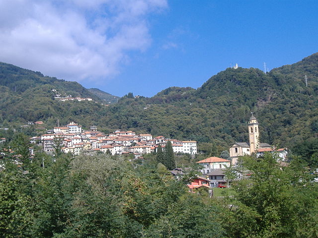
Гарцено (Garzeno, Garzeno)
.svg)
- коммуна Италии
 Hiking in Гарцено
Garzeno, located in the beautiful Valtellina region of Italy, is a lesser-known yet charming destination for hiking enthusiasts. Nestled in the Lombardy region, it offers stunning landscapes, rich flora and fauna, and a range of trails suitable for various skill levels.
Key Highlights for Hiking in Garzeno:
-
Scenic Trails: The area boasts numerous hiking trails that wind through picturesque mountains, forests, and meadows. You can expect to encounter breathtaking views of the surrounding valleys and peaks.
-
Nature Diversity: Hiking in Garzeno allows you to experience a wide range of biodiversity. Depending on the season, you may see various wildflowers, mushrooms, and wildlife, including deer and numerous bird species.
-
Cultural Aspects: The region has a rich cultural heritage. Along the trails, you may come across traditional villages, ancient churches, and historic farming landscapes. These elements add a unique charm and context to your hiking experience.
-
Trails for All Levels: Whether you are a beginner or an experienced hiker, Garzeno has something to offer. Local maps and information centers provide details on trail difficulty and lengths, ensuring hikers can choose routes appropriate for their skill level.
-
Best Hiking Seasons: The ideal times to hike in Garzeno are spring and autumn when the weather is mild and the landscapes are particularly beautiful. Summer can be pleasant but may also bring higher temperatures.
-
Local Tips: Always carry enough water, snacks, and a map or a GPS device. It's also advisable to check weather conditions before heading out and, if needed, inform someone about your hiking plans.
Recommended Hikes:
-
Trail to the Church of Santa Maria: A moderately challenging hike that leads to a scenic church with panoramic views of the surrounding area.
-
Aveto Valley Loop: This trail offers a beautiful loop through the Aveto Valley, showcasing diverse landscapes and wildlife.
-
Ridge Walks: For those looking for more adventure, consider hikes along the ridges that provide breathtaking views, especially during sunrise or sunset.
Remember to respect local wildlife and the environment while hiking, follow Leave No Trace principles, and enjoy the stunning natural beauty that Garzeno has to offer!
- Страна:

- Почтовый код: 22010
- Телефонный код: 0344
- Код автомобильного номера: CO
- Координаты: 46° 8' 0" N, 9° 15' 0" E


- GPS треки (wikiloc): [Ссылка]
- Высота над уровнем моря: 662 м m
- Площадь: 28.76 кв.км
- Население: 754
- Веб сайт: http://www.comune.garzeno.co.it
- Википедия русская: wiki(ru)
- Википедия английская: wiki(en)
- Википедия национальная: wiki(it)
- Хранилище Wikidata: Wikidata: Q47332
- Катеория в википедии: [Ссылка]
- код Freebase: [/m/0gj08x]
- код GeoNames: Альт: [6537096]
- код VIAF: Альт: [246984594]
- ID отношения в OpenStreetMap: [46867]
- код TGN: [1044767]
- код ISTAT: 013106
- кадастровый код Италии: D930
Граничит с регионами:


Тичино
- кантон в Швейцарии
Hiking in Тичино
The Canton of Ticino, located in southern Switzerland, is a breathtaking destination for hiking enthusiasts. Known for its stunning landscapes, picturesque villages, and mild Mediterranean climate, Ticino offers a variety of trails suitable for all levels of hikers. Here are some highlights:...
- Страна:

- Столица: Кьяссо
- Телефонный код: 091
- Код автомобильного номера: TI
- Координаты: 46° 19' 0" N, 8° 49' 0" E
- GPS треки (wikiloc): [Ссылка]
- Высота над уровнем моря: 238 м m
- Площадь: 2812.15 кв.км
- Веб сайт: [Ссылка]


Сан-Бартоломео-Валь-Каварнья
- коммуна Италии
Hiking in Сан-Бартоломео-Валь-Каварнья
San Bartolomeo Val Cavargna is a picturesque area located in the Lombardy region of Italy, nestled within the Italian Alps. It offers a range of hiking opportunities for both novice and experienced hikers, characterized by stunning landscapes, including mountains, valleys, and forests. Here are some key aspects to consider when hiking in this region:...
- Страна:
- Почтовый код: 22010
- Телефонный код: 0344
- Код автомобильного номера: CO
- Координаты: 46° 5' 0" N, 9° 9' 0" E
- GPS треки (wikiloc): [Ссылка]
- Высота над уровнем моря: 830 м m
- Площадь: 10.51 кв.км
- Население: 1010
- Веб сайт: [Ссылка]
Сан-Наццаро-Валь-Каварнья
- коммуна Италии
Hiking in Сан-Наццаро-Валь-Каварнья
San Nazzaro Val Cavargna is a picturesque village located in the province of Como, in the Lombardy region of Italy. Nestled in the Val Cavargna valley, it offers a range of excellent hiking opportunities amid stunning natural landscapes, rich flora, and charming traditional architecture....
- Страна:
- Почтовый код: 22010
- Телефонный код: 0344
- Код автомобильного номера: CO
- Координаты: 46° 5' 0" N, 9° 8' 0" E
- GPS треки (wikiloc): [Ссылка]
- Высота над уровнем моря: 995 м m
- Площадь: 12.99 кв.км
- Население: 302
- Веб сайт: [Ссылка]
Кремия
- коммуна Италии
Hiking in Кремия
Cremia is a charming village located on the western shores of Lake Como in Italy, and it offers a variety of hiking opportunities in a beautiful natural setting. Below are some highlights and recommended trails for hiking in and around Cremia:...
- Страна:
- Почтовый код: 22010
- Телефонный код: 0344
- Код автомобильного номера: CO
- Координаты: 46° 5' 14" N, 9° 16' 17" E
- GPS треки (wikiloc): [Ссылка]
- Высота над уровнем моря: 330 м m
- Площадь: 10.14 кв.км
- Население: 675
- Веб сайт: [Ссылка]

Плезио
- коммуна Италии
Hiking in Плезио
Plesio is a charming village located in the Lombardy region of Italy, near Lake Como. It is a part of the Valtellina Valley and offers stunning views of the surrounding mountains and the lake itself. Hiking in this area can be an incredible experience, as it is blessed with natural beauty and a variety of trails suited for different skill levels....
- Страна:
- Почтовый код: 22010
- Телефонный код: 0344
- Код автомобильного номера: CO
- Координаты: 46° 2' 58" N, 9° 13' 32" E
- GPS треки (wikiloc): [Ссылка]
- Высота над уровнем моря: 595 м m
- Площадь: 16.9 кв.км
- Население: 840
- Веб сайт: [Ссылка]


Пьянелло-дель-Ларио
- коммуна Италии
Hiking in Пьянелло-дель-Ларио
Pianello del Lario is a charming village located on the western shore of Lake Como in Italy. It's situated amidst breathtaking natural landscapes, making it an appealing destination for hiking enthusiasts. Here are some highlights and tips for hiking in and around Pianello del Lario:...
- Страна:
- Почтовый код: 22010
- Телефонный код: 0344
- Код автомобильного номера: CO
- Координаты: 46° 6' 10" N, 9° 16' 35" E
- GPS треки (wikiloc): [Ссылка]
- Высота над уровнем моря: 200 м m
- Площадь: 9.8 кв.км
- Население: 1028
- Веб сайт: [Ссылка]

Gravedona ed Uniti
- коммуна Италии
Hiking in Gravedona ed Uniti
Gravedona ed Uniti is a charming town located on the northern shores of Lake Como in Italy, known for its beautiful landscapes and rich history. Hiking in this area offers a variety of trails that cater to different skill levels, providing stunning views of the lake, surrounding mountains, and picturesque villages....
- Страна:
- Почтовый код: 22015
- Телефонный код: 0344
- Код автомобильного номера: CO
- Координаты: 46° 9' 0" N, 9° 18' 0" E
- GPS треки (wikiloc): [Ссылка]
- Высота над уровнем моря: 201 м m
- Площадь: 39.85 кв.км
- Население: 4198
- Веб сайт: [Ссылка]
Грандола-ед-Унити
- коммуна Италии
Hiking in Грандола-ед-Унити
Grandola ed Uniti, located in the Italian region of Lombardy, is surrounded by stunning natural landscapes, making it an excellent destination for hiking enthusiasts. This area has a mix of terrain, including mountainous regions, forests, and lakes, providing a variety of hiking experiences suitable for different skill levels....
- Страна:
- Почтовый код: 22010
- Телефонный код: 0344
- Код автомобильного номера: CO
- Координаты: 46° 2' 0" N, 9° 13' 0" E
- GPS треки (wikiloc): [Ссылка]
- Высота над уровнем моря: 443 м m
- Площадь: 16.9 кв.км
- Население: 1298
- Веб сайт: [Ссылка]


Кузино
- коммуна Италии
Hiking in Кузино
Hiking in Cusino, a region in northern Italy, offers a delightful experience for outdoor enthusiasts. Set in the Italian Alps, Cusino is known for its stunning landscapes, diverse flora and fauna, and a variety of trails suitable for all experience levels. Here’s what you can expect:...
- Страна:
- Почтовый код: 22010
- Телефонный код: 0344
- Код автомобильного номера: CO
- Координаты: 46° 4' 0" N, 9° 9' 0" E
- GPS треки (wikiloc): [Ссылка]
- Высота над уровнем моря: 800 м m
- Площадь: 9.65 кв.км
- Население: 216
- Веб сайт: [Ссылка]


Донго
- коммуна Италии
Hiking in Донго
Dongo, located in the Lombardy region of northern Italy along the shores of Lake Como, is a beautiful area for hiking and outdoor activities. Here are some key points and popular hiking opportunities in and around Dongo:...
- Страна:
- Почтовый код: 22014
- Телефонный код: 0344
- Код автомобильного номера: CO
- Координаты: 46° 7' 48" N, 9° 16' 54" E
- GPS треки (wikiloc): [Ссылка]
- Высота над уровнем моря: 208 м m
- Площадь: 7.04 кв.км
- Население: 3380
- Веб сайт: [Ссылка]
Sant'Antonio
Hiking in Sant'Antonio
Sant'Antonio, located near Bellinzona in the canton of Ticino, Switzerland, is a fantastic area for hiking, combining beautiful landscapes with cultural and historical elements. Here’s a guide to what you can expect when hiking in this picturesque region....
- Страна:
- Почтовый код: 6583
- Телефонный код: 091
- Код автомобильного номера: TI
- Координаты: 46° 10' 0" N, 9° 4' 0" E
- GPS треки (wikiloc): [Ссылка]
- Высота над уровнем моря: 822 м m
- Площадь: 33.57 кв.км
- Веб сайт: [Ссылка]