Geraise (Geraise)

- коммуна во Франции
 Hiking in Geraise
Geraise, while not a widely recognized hiking destination, may refer to a specific area or trail that could be known locally or under a different name. If it is meant to indicate a less popular or regional hiking area, local resources or hiking clubs can provide you with detailed trail maps, difficulty levels, and any unique features of that environment.
If you have a specific place in mind that might be known for its hiking trails, please provide more context or correct any terminology. In the meantime, here are general hiking tips that you can apply no matter the location:
-
Plan Your Route: Research the available trails, their lengths, and difficulty levels. Check local maps and guidebooks.
-
Check Weather Conditions: Before heading out, make sure to check the weather forecast and be prepared for sudden changes.
-
Pack Accordingly: Bring enough water, snacks, a first-aid kit, navigation tools, and appropriate clothing for the weather conditions.
-
Leave No Trace: Respect the environment by staying on trails, packing out all trash, and being mindful of wildlife.
-
Safety First: Let someone know your hiking plans, carry a map or GPS, and ensure your phone is charged for emergencies.
If you provide me with more details or confirm the name of the location you are interested in, I can offer more tailored information!
- Страна:

- Почтовый код: 39110
- Координаты: 46° 57' 24" N, 5° 56' 54" E


- GPS треки (wikiloc): [Ссылка]
- Площадь: 6.04 кв.км
- Население: 40
- Википедия английская: wiki(en)
- Википедия национальная: wiki(fr)
- Хранилище Wikidata: Wikidata: Q321958
- Катеория в википедии: [Ссылка]
- код Freebase: [/m/03npjdq]
- код Freebase: [/m/03npjdq]
- код GeoNames: Альт: [6433570]
- код GeoNames: Альт: [6433570]
- номер SIREN: [213902489]
- номер SIREN: [213902489]
- код BNF: [15258612t]
- код BNF: [15258612t]
- код муниципалитета INSEE: 39248
- код муниципалитета INSEE: 39248
Граничит с регионами:


Sainte-Anne
Hiking in Sainte-Anne
Sainte-Anne, located in the Doubs department in eastern France, offers a range of hiking opportunities that showcase the stunning natural beauty of the Jura Mountains. The area is characterized by its picturesque landscapes, lush forests, and diverse wildlife, making it a fantastic destination for outdoor enthusiasts....
- Страна:
- Почтовый код: 25270
- Координаты: 46° 57' 16" N, 5° 59' 7" E
- GPS треки (wikiloc): [Ссылка]
- Площадь: 6.64 кв.км
- Население: 39


Clucy
- коммуна во Франции
Hiking in Clucy
It seems like there may be a typo or a misunderstanding regarding "Clucy." If you meant "Cluj," as in Cluj-Napoca, Romania, I can provide some information on hiking in that region. Alternatively, if you were referring to another location, feel free to clarify....
- Страна:
- Почтовый код: 39110
- Координаты: 46° 56' 47" N, 5° 54' 13" E
- GPS треки (wikiloc): [Ссылка]
- Площадь: 5.13 кв.км
- Население: 83


Cernans
- коммуна во Франции
Hiking in Cernans
I'm sorry, but there seems to be a misunderstanding. As of my last knowledge update in October 2023, there isn't a widely recognized hiking destination by the name "Cernans." If you meant a specific area or park that could be associated with that name, please provide more context or check the spelling....
- Страна:
- Почтовый код: 39110
- Координаты: 46° 55' 55" N, 5° 55' 54" E
- GPS треки (wikiloc): [Ссылка]
- Площадь: 5.51 кв.км
- Население: 140

Salins-les-Bains
- коммуна во Франции
Hiking in Salins-les-Bains
Salins-les-Bains, located in the Jura region of France, is known for its beautiful landscapes, rich historical heritage, and therapeutic salt springs. Hiking in this area offers a mix of natural beauty, cultural landmarks, and opportunities to enjoy the unique geology of the Jura Mountains....
- Страна:
- Почтовый код: 39110
- Координаты: 46° 56' 28" N, 5° 52' 42" E
- GPS треки (wikiloc): [Ссылка]
- Высота над уровнем моря: 350 м m
- Площадь: 24.68 кв.км
- Население: 2718
- Веб сайт: [Ссылка]

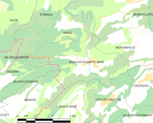
Nans-sous-Sainte-Anne
- коммуна во Франции
Hiking in Nans-sous-Sainte-Anne
Nans-sous-Sainte-Anne is a charming village located in the Jura region of France, known for its stunning natural landscapes, rich biodiversity, and various hiking opportunities. The village is nestled within the Jura Mountains, which offer a mix of lush forests, rolling hills, rivers, and captivating rock formations....
- Страна:
- Почтовый код: 25330
- Координаты: 46° 58' 36" N, 5° 59' 56" E
- GPS треки (wikiloc): [Ссылка]
- Площадь: 8.86 кв.км
- Население: 139