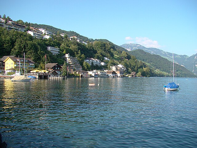
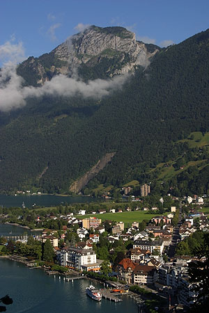
Герзау (Gersau, Gersau)

 Hiking in Герзау
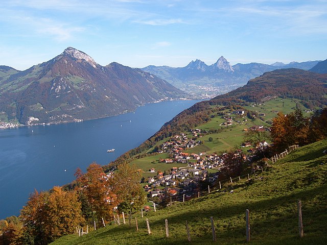
Gersau is a picturesque town located on the shores of Lake Lucerne in Switzerland, surrounded by stunning mountains and rich natural landscapes, making it a fantastic destination for hiking enthusiasts. Here are some highlights and tips for hiking in and around Gersau:
Scenic Trails
-
Rigi Panorama Trail: This trail provides breathtaking views of Lake Lucerne and the surrounding mountains. You can start from Gersau and hike towards Rigi Kulm, which is known as the "Queen of Mountains". The trail offers a mix of easy paths and some more challenging sections.
-
Weg zur Hohlichten: A relatively easy hike that offers beautiful views of the lake and the surrounding hills. It's accessible for families and not too strenuous, making it ideal for a leisurely day out.
-
Hiking towards the Fronalp-Stock: This trail offers a bit more challenge and leads to higher altitudes, with rewarding views over the Swiss landscape. It's advisable to check weather conditions and trail status before heading out to higher elevations.
Points of Interest
- Lake Lucerne: Besides hiking, enjoy the tranquil beauty of Lake Lucerne. You can incorporate a boat trip to explore nearby locations, further enriching your hiking experience.
- Gersau’s Historical Village: Make sure to explore the charming village of Gersau, known for its well-preserved historic buildings and the scenic waterfront.
Practical Tips
- Hiking Season: The best times to hike in Gersau are late spring through early autumn (May to October). Always check the weather conditions before planning your trip.
- Gear: Wear proper hiking shoes and dress in layers to adjust for changes in temperature and terrain. Carrying enough water and snacks is also essential.
- Navigation: Ensure you have a good hiking map or a GPS-enabled device, as some trails may not be well marked.
Accessibility
Gersau is accessible by train and ferry, making it easy to reach from larger Swiss cities like Lucerne. Public transport options can also help you reach different trailheads if you don’t want to hike from the village itself.
With its beautiful landscapes and diverse hiking trails, Gersau is a delightful destination for both novice and experienced hikers. Enjoy your outdoor adventure!
- Страна:

- Почтовый код: 6442
- Телефонный код: 041
- Код автомобильного номера: SZ
- Координаты: 46° 59' 28" N, 8° 31' 29" E


- GPS треки (wikiloc): [Ссылка]
- Высота над уровнем моря: 435 м m
- Площадь: 23.70 кв.км
- Население: 2279
- Веб сайт: http://www.gersau.ch
- Википедия русская: wiki(ru)
- Википедия английская: wiki(en)
- Википедия национальная: wiki(de)
- Хранилище Wikidata: Wikidata: Q64380
- Катеория в википедии: [Ссылка]
- код Freebase: [/m/05rdqj]
- код GeoNames: Альт: [7285908]
- код VIAF: Альт: [147233692]
- ID отношения в OpenStreetMap: [1683075]
- идентификатор местоположения ArchINFORM: [46002]
- идентификатор HDS: [711]
- код швейцарского муниципалитета: [1311]
Граничит с регионами:


Вицнау
Hiking in Вицнау
Vitznau is a picturesque village situated on the shores of Lake Lucerne in Switzerland, surrounded by stunning mountains, making it an excellent destination for hiking enthusiasts. Here are some highlights for hiking in the Vitznau area:...
- Страна:
- Почтовый код: 6354
- Телефонный код: 041
- Код автомобильного номера: LU
- Координаты: 47° 1' 1" N, 8° 29' 30" E
- GPS треки (wikiloc): [Ссылка]
- Высота над уровнем моря: 917 м m
- Площадь: 11.76 кв.км
- Население: 1381
- Веб сайт: [Ссылка]

Эннетбюрген
Hiking in Эннетбюрген
Ennetbürgen is a picturesque village located near Lake Lucerne in the canton of Nidwalden, Switzerland. It offers a variety of hiking opportunities that immerse you in breathtaking natural landscapes, including stunning lake views and mountainous terrain. Here are some highlights and tips for hiking in and around Ennetbürgen:...
- Страна:
- Почтовый код: 6373
- Телефонный код: 041
- Код автомобильного номера: NW
- Координаты: 46° 59' 4" N, 8° 24' 50" E
- GPS треки (wikiloc): [Ссылка]
- Высота над уровнем моря: 435 м m
- Площадь: 17.70 кв.км
- Население: 4698
- Веб сайт: [Ссылка]


Буокс
Hiking in Буокс
Buochs is a charming municipality located in the canton of Nidwalden in Switzerland, nestled at the northern end of Lake Lucerne. The area offers stunning natural beauty and a variety of hiking opportunities suitable for different skill levels. Here are some highlights and tips for hiking in and around Buochs:...
- Страна:
- Почтовый код: 6374
- Телефонный код: 041
- Код автомобильного номера: NW
- Координаты: 46° 58' 29" N, 8° 25' 14" E
- GPS треки (wikiloc): [Ссылка]
- Высота над уровнем моря: 436 м m
- Площадь: 12.04 кв.км
- Население: 5409
- Веб сайт: [Ссылка]

Ингенболь
Hiking in Ингенболь
Ingenbohl, located in the canton of Schwyz in Switzerland, is a great place for hiking enthusiasts. Nestled near Lake Lauerz and the surrounding mountains, Ingenbohl offers a mix of flat lakeside trails and more challenging mountainous paths....
- Страна:
- Почтовый код: 6440
- Телефонный код: 041
- Код автомобильного номера: SZ
- Координаты: 47° 0' 14" N, 8° 35' 54" E
- GPS треки (wikiloc): [Ссылка]
- Высота над уровнем моря: 574 м m
- Площадь: 16.20 кв.км
- Население: 8856
- Веб сайт: [Ссылка]


Беккенрид
Hiking in Беккенрид
Beckenried, located in the canton of Nidwalden, Switzerland, is a beautiful destination for hiking enthusiasts. Nestled between Lake Lucerne and the surrounding mountains, it offers a variety of trails with stunning views, diverse landscapes, and the opportunity to explore the natural beauty of the region....
- Страна:
- Почтовый код: 6375
- Телефонный код: 041
- Код автомобильного номера: NW
- Координаты: 46° 57' 59" N, 8° 28' 29" E
- GPS треки (wikiloc): [Ссылка]
- Высота над уровнем моря: 448 м m
- Площадь: 32.95 кв.км
- Население: 3654
- Веб сайт: [Ссылка]

Эмметтен
Hiking in Эмметтен
Emmetten is a charming village located in Switzerland, offering stunning views of Lake Lucerne and the surrounding mountains, making it an excellent destination for hiking enthusiasts. Here are some key points to consider when planning a hike in Emmetten:...
- Страна:
- Почтовый код: 6376
- Телефонный код: 041
- Код автомобильного номера: NW
- Координаты: 46° 57' 24" N, 8° 31' 5" E
- GPS треки (wikiloc): [Ссылка]
- Высота над уровнем моря: 774 м m
- Площадь: 28.63 кв.км
- Население: 1401
- Веб сайт: [Ссылка]


Лауэрц
- коммуна в Швейцарии
Hiking in Лауэрц
Lauerz is a beautiful area located in Switzerland, known for its picturesque landscapes and hiking opportunities. Situated near Lake Lauerz, it offers stunning views of the surrounding mountains and the tranquil waters of the lake. Here are some highlights and tips for hiking in the Lauerz area:...
- Страна:
- Почтовый код: 6424
- Телефонный код: 041
- Код автомобильного номера: SZ
- Координаты: 47° 1' 29" N, 8° 34' 50" E
- GPS треки (wikiloc): [Ссылка]
- Высота над уровнем моря: 699 м m
- Площадь: 9.20 кв.км
- Население: 1081
- Веб сайт: [Ссылка]


Арт
Hiking in Арт
Arth, located in the Swiss Alps, offers stunning landscapes and a variety of hiking opportunities for outdoor enthusiasts. Here are some key points about hiking in the Arth region:...
- Страна:
- Почтовый код: 6415
- Телефонный код: 041
- Код автомобильного номера: SZ
- Координаты: 47° 3' 52" N, 8° 31' 27" E
- GPS треки (wikiloc): [Ссылка]
- Высота над уровнем моря: 422 м m
- Площадь: 48.50 кв.км
- Население: 11877
- Веб сайт: [Ссылка]