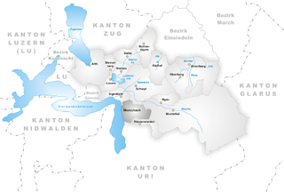
Ингенболь (Ingenbohl, Ingenbohl)

 Hiking in Ингенболь
Ingenbohl, located in the canton of Schwyz in Switzerland, is a great place for hiking enthusiasts. Nestled near Lake Lauerz and the surrounding mountains, Ingenbohl offers a mix of flat lakeside trails and more challenging mountainous paths.
Hiking Trails
-
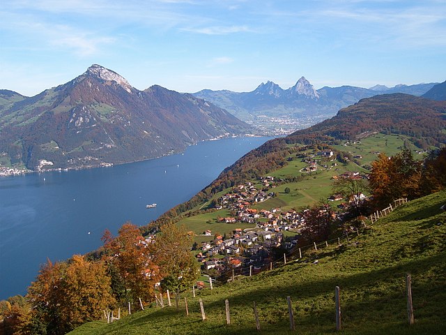
Lake Lauerz Trail: This is a relatively easy hike that offers stunning views of the lake and is suitable for families. The trail goes around the lake and provides opportunities for picnicking and enjoying nature.
-
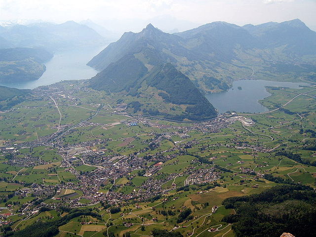
Bürgenstock Felsenweg: A bit more challenging, this hike leads you from Ingenbohl up to Bürgenstock. The route features dramatic cliffs and breathtaking panoramas of Lake Lucerne and the surrounding peaks. The path is well marked but does require good hiking gear due to some steep sections.
-
Rigi: While not directly in Ingenbohl, a short journey will take you to Rigi, often referred to as the "Queen of the Mountains." From Rigi’s summit, several trails lead down with breathtaking views.
-
Schwyzer Alpen Trails: Ingenbohl provides access to various trails in the nearby Schwyzer Alps. These trails vary in difficulty and length, catering to both casual walkers and experienced hikers.
Things to Consider
-
Season: Spring through autumn are the best times for hiking in Ingenbohl, with summer offering warmer temperatures and long days.
-
Gear: Proper hiking gear is essential. This includes sturdy hiking boots, weather-appropriate clothing, and enough water and food for your hike.
-
Navigation: Although many trails are well-marked, consider bringing a map or using a hiking app for navigation.
-
Wildlife: Be aware that the area is home to various wildlife. While most animals will avoid humans, it's good to respect their habitats and remember to not feed them.
-
Local Facilities: Ingenbohl has various restaurants and accommodations, making it easy to find a place to rest and enjoy local Swiss cuisine after a day on the trails.
Whether you're looking for a serene lakeside walk or a more strenuous hike into the mountains, Ingenbohl offers a variety of options to satisfy any hiking craving. Always remember to check local conditions and trail maps before you head out!
- Страна:

- Почтовый код: 6440
- Телефонный код: 041
- Код автомобильного номера: SZ
- Координаты: 47° 0' 14" N, 8° 35' 54" E


- GPS треки (wikiloc): [Ссылка]
- Высота над уровнем моря: 574 м m
- Площадь: 16.20 кв.км
- Население: 8856
- Веб сайт: http://www.ingenbohl.ch
- Википедия русская: wiki(ru)
- Википедия английская: wiki(en)
- Википедия национальная: wiki(de)
- Хранилище Wikidata: Wikidata: Q66330
- Катеория в википедии: [Ссылка]
- код Freebase: [/m/0fw4zq]
- код GeoNames: Альт: [7286138]
- код VIAF: Альт: [236381063]
- ID отношения в OpenStreetMap: [1683083]
- идентификатор HDS: [728]
- код швейцарского муниципалитета: [1364]
Граничит с регионами:


Герзау
Hiking in Герзау
Gersau is a picturesque town located on the shores of Lake Lucerne in Switzerland, surrounded by stunning mountains and rich natural landscapes, making it a fantastic destination for hiking enthusiasts. Here are some highlights and tips for hiking in and around Gersau:...
- Страна:
- Почтовый код: 6442
- Телефонный код: 041
- Код автомобильного номера: SZ
- Координаты: 46° 59' 28" N, 8° 31' 29" E
- GPS треки (wikiloc): [Ссылка]
- Высота над уровнем моря: 435 м m
- Площадь: 23.70 кв.км
- Население: 2279
- Веб сайт: [Ссылка]


Зелисберг
- коммуна в Швейцарии
Hiking in Зелисберг
Seelisberg is a picturesque village located in the Uri region of Switzerland, known for its stunning views of Lake Lucerne and the surrounding mountains. It offers a variety of hiking trails suitable for different skill levels, making it an excellent destination for both novice and experienced hikers....
- Страна:
- Почтовый код: 6377
- Телефонный код: 041
- Код автомобильного номера: UR
- Координаты: 46° 57' 29" N, 8° 34' 21" E
- GPS треки (wikiloc): [Ссылка]
- Высота над уровнем моря: 736 м m
- Площадь: 13.34 кв.км
- Население: 679
- Веб сайт: [Ссылка]

Моршах
- коммуна в Швейцарии
Hiking in Моршах
Morschach, a charming village located in Switzerland, is a great destination for hiking enthusiasts. Nestled in the scenic landscape of central Switzerland, it offers stunning views of Lake Lucerne and the surrounding mountains. Here are some highlights and tips for hiking in Morschach:...
- Страна:
- Почтовый код: 6443
- Телефонный код: 041
- Код автомобильного номера: SZ
- Координаты: 46° 58' 54" N, 8° 37' 11" E
- GPS треки (wikiloc): [Ссылка]
- Высота над уровнем моря: 1682 м m
- Площадь: 23.4 кв.км
- Население: 1103
- Веб сайт: [Ссылка]

Швиц
- город в Швейцарии, столица кантона Швиц
Hiking in Швиц
Hiking in Schwyz, located in central Switzerland, offers stunning landscapes, rich history, and a variety of trails catering to different skill levels. Here are some highlights and tips for hiking in this beautiful region:...
- Страна:
- Почтовый код: 6430
- Телефонный код: 041
- Код автомобильного номера: SZ
- Координаты: 47° 1' 14" N, 8° 39' 30" E
- GPS треки (wikiloc): [Ссылка]
- Высота над уровнем моря: 852 м m
- Площадь: 53.28 кв.км
- Население: 15000
- Веб сайт: [Ссылка]

Эмметтен
Hiking in Эмметтен
Emmetten is a charming village located in Switzerland, offering stunning views of Lake Lucerne and the surrounding mountains, making it an excellent destination for hiking enthusiasts. Here are some key points to consider when planning a hike in Emmetten:...
- Страна:
- Почтовый код: 6376
- Телефонный код: 041
- Код автомобильного номера: NW
- Координаты: 46° 57' 24" N, 8° 31' 5" E
- GPS треки (wikiloc): [Ссылка]
- Высота над уровнем моря: 774 м m
- Площадь: 28.63 кв.км
- Население: 1401
- Веб сайт: [Ссылка]


Лауэрц
- коммуна в Швейцарии
Hiking in Лауэрц
Lauerz is a beautiful area located in Switzerland, known for its picturesque landscapes and hiking opportunities. Situated near Lake Lauerz, it offers stunning views of the surrounding mountains and the tranquil waters of the lake. Here are some highlights and tips for hiking in the Lauerz area:...
- Страна:
- Почтовый код: 6424
- Телефонный код: 041
- Код автомобильного номера: SZ
- Координаты: 47° 1' 29" N, 8° 34' 50" E
- GPS треки (wikiloc): [Ссылка]
- Высота над уровнем моря: 699 м m
- Площадь: 9.20 кв.км
- Население: 1081
- Веб сайт: [Ссылка]