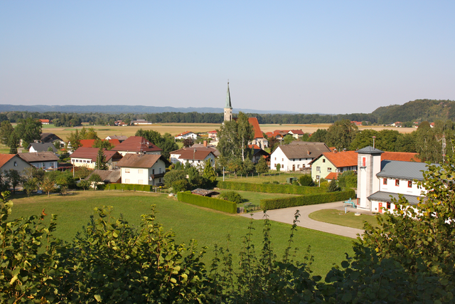
Гильгенберг-на-Вайльхарте (Gilgenberg am Weilhart, Gilgenberg am Weilhart)

- коммуна в Австрии
 Hiking in Гильгенберг-на-Вайльхарте
Gilgenberg am Weilhart is a picturesque village in Austria, located in the state of Upper Austria. While it might not be as well-known as some of the larger hiking destinations, it offers a number of scenic trails and beautiful countryside, making it a great spot for hiking enthusiasts.
Hiking Highlights:
-
Scenic Trails: The surrounding area is characterized by rolling hills, lush forests, and open farmland. This can provide a variety of trails ranging from easy to moderate difficulty.
-
Nature Experience: Hiking in Gilgenberg am Weilhart allows hikers to immerse themselves in the natural beauty of the region, where they can observe local flora and fauna, as well as enjoy the serenity of the rural landscape.
-
Local Routes: There may be marked hiking routes that connect to neighboring villages, allowing for a more extended exploration of the region. These paths often include beautiful viewpoints overlooking the countryside.
-
Seasonal Hiking: Spring and summer offer vibrant landscapes, while autumn brings stunning foliage. Winter hiking may also be possible, depending on weather conditions, particularly if you're interested in snowshoeing.
-
Cultural Aspects: As you hike, you may also pass by local farms, charming homes, and possibly even historical landmarks, providing a glimpse into the local culture and lifestyle.
Tips for Hiking in Gilgenberg am Weilhart:
- Check Local Maps and Signage: Always have a reliable map or a GPS device, as trail markings can vary.
- Prepare for Weather: The weather can change quickly, so dress in layers and pack rain gear if necessary.
- Stay Hydrated and Energized: Bring enough water and snacks to keep your energy levels up, especially on longer hikes.
- Respect Nature: Stay on marked trails, and be mindful of local wildlife and plants.
Before heading out, it’s a good idea to check for local hiking information or resources, such as guides or visitor centers, that can provide updates on trail conditions and recommendations for local routes. Enjoy your hiking experience in Gilgenberg am Weilhart!
- Страна:

- Почтовый код: 5133
- Телефонный код: 07728
- Код автомобильного номера: BR
- Координаты: 48° 7' 54" N, 12° 56' 21" E


- GPS треки (wikiloc): [Ссылка]
- Высота над уровнем моря: 466 м m
- Площадь: 26.58 кв.км
- Население: 1327
- Веб сайт: http://www.gilgenberg.at/
- Википедия русская: wiki(ru)
- Википедия английская: wiki(en)
- Википедия национальная: wiki(de)
- Хранилище Wikidata: Wikidata: Q534212
- Катеория в википедии: [Ссылка]
- код Freebase: [/m/03gv253]
- код GeoNames: Альт: [7873095]
- код VIAF: Альт: [234338637]
- код GND: Альт: [4633075-6]
- код австрийского муниципалитета: [40410]
Граничит с регионами:

Геретсберг
Hiking in Геретсберг
Geretsberg, located in Austria, offers beautiful hiking opportunities amidst stunning natural landscapes. The region is characterized by rolling hills, lush forests, and picturesque views, making it a delightful destination for outdoor enthusiasts....
- Страна:
- Телефонный код: 07748
- Код автомобильного номера: BR
- Координаты: 48° 5' 20" N, 12° 56' 5" E
- GPS треки (wikiloc): [Ссылка]
- Высота над уровнем моря: 491 м m
- Площадь: 37.54 кв.км
- Население: 1187
- Веб сайт: [Ссылка]
Ибераккерн
Hiking in Ибераккерн
Überackern is a beautiful location for hiking, nestled in Austria. While the specifics can vary based on the specific trails and areas you choose, here are some general aspects to consider when hiking in and around Überackern:...
- Страна:
- Почтовый код: 5122
- Телефонный код: 07727
- Код автомобильного номера: BR
- Координаты: 48° 11' 35" N, 12° 52' 36" E
- GPS треки (wikiloc): [Ссылка]
- Высота над уровнем моря: 356 м m
- Площадь: 27.1 кв.км
- Население: 685
- Веб сайт: [Ссылка]

Ханденберг
Hiking in Ханденберг
Handenberg, situated in Austria, offers beautiful landscapes and a variety of hiking trails suited for different skill levels. The region is known for its stunning natural scenery, including lush forests, rolling hills, and panoramic views of the surrounding areas. Here are some key highlights and tips for hiking in Handenberg:...
- Страна:
- Почтовый код: 5144
- Телефонный код: 07748
- Код автомобильного номера: BR
- Координаты: 48° 8' 0" N, 13° 0' 30" E
- GPS треки (wikiloc): [Ссылка]
- Высота над уровнем моря: 497 м m
- Площадь: 27.64 кв.км
- Население: 1290
- Веб сайт: [Ссылка]
Шванд
- коммуна в Австрии
Hiking in Шванд
Schwand im Innkreis, located in Austria, offers a picturesque backdrop for hiking enthusiasts. This region is part of Upper Austria and is characterized by its beautiful landscapes, rolling hills, and lush greenery, making it an ideal spot for outdoor activities....
- Страна:
- Почтовый код: 5134
- Телефонный код: 07728
- Код автомобильного номера: BR
- Координаты: 48° 10' 42" N, 12° 58' 5" E
- GPS треки (wikiloc): [Ссылка]
- Высота над уровнем моря: 423 м m
- Площадь: 17.13 кв.км
- Население: 972
- Веб сайт: [Ссылка]


Хохбург-Ах
Hiking in Хохбург-Ах
Hochburg-Ach, located in Bavaria, Germany, near the Austrian border, offers a variety of hiking opportunities that showcase the beautiful landscapes of the region. Here are some key points about hiking in Hochburg-Ach:...
- Страна:
- Почтовый код: 5122
- Телефонный код: 07727
- Код автомобильного номера: BR
- Координаты: 48° 7' 50" N, 12° 52' 40" E
- GPS треки (wikiloc): [Ссылка]
- Высота над уровнем моря: 462 м m
- Площадь: 40.12 кв.км
- Население: 3236
- Веб сайт: [Ссылка]

Эггельсберг
Hiking in Эггельсберг
Eggelsberg, located in Austria, offers beautiful hiking opportunities, especially for those who appreciate scenic landscapes and a tranquil environment. The region is characterized by rolling hills, lush forests, and charming rural views, making it suitable for both casual walkers and more seasoned hikers....
- Страна:
- Почтовый код: 5142
- Телефонный код: 07748
- Код автомобильного номера: BR
- Координаты: 48° 4' 40" N, 12° 59' 34" E
- GPS треки (wikiloc): [Ссылка]
- Высота над уровнем моря: 531 м m
- Площадь: 24.15 кв.км
- Население: 2365
- Веб сайт: [Ссылка]