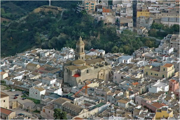
Джиноза (Ginosa, Ginosa)
.svg)
- коммуна Италии
 Hiking in Джиноза
Ginosa, located in the Apulia region of Italy, is an excellent destination for hiking enthusiasts. The area is known for its unique landscapes, including rocky cliffs, the Gravina di Ginosa canyon, rural trails, and Mediterranean scrub.
Key Highlights for Hiking in Ginosa:
-
Gravina di Ginosa: This impressive ravine offers stunning views and rugged terrain. The trails around the canyon provide opportunities for both experienced and novice hikers. Be sure to bring plenty of water, as there may be limited access to amenities along the way.
-
Historic Sites: While exploring the trails, you can encounter several historical sites, including ancient cave dwellings and ruins. The mix of nature and history enriches the hiking experience, allowing you to discover the cultural heritage of the region.
-
Countryside Trails: Ginosa is surrounded by beautiful countryside, characterized by olive groves, vineyards, and farmland. These paths are often less crowded and perfect for a peaceful hike, ideal for enjoying the local flora and fauna.
-
Pathways to the Coast: If you're up for a longer hike, there are routes that lead toward the Ionian Sea. These trails typically offer picturesque views of the coastline and are perfect for those looking to blend mountain and beach experiences.
-
Wildlife Watching: The area is home to a variety of wildlife. Being quiet and patient can reward you with glimpses of local fauna, including birds and other animals unique to the Mediterranean ecosystem.
Tips for Hiking in Ginosa:
-
Footwear: Wear sturdy hiking shoes as the terrain can vary from rocky paths to softer earth.
-
Weather Preparedness: Check the weather before heading out, as conditions can change rapidly in the spring and autumn.
-
Local Guides: If you’re unsure about the trails, consider hiring a local guide who can provide insights into the best routes and local history.
-
Hydration and Snacks: Always carry enough water and some snacks to keep your energy levels up during your hike.
-
Leave No Trace: Protect the natural beauty of Ginosa by following Leave No Trace principles; pack out what you pack in.
Ginosa’s combination of breathtaking landscapes and cultural significance makes it a wonderful hiking destination. Whether you're looking for a leisurely walk or a challenging trek, you'll find plenty to explore in this charming Italian town.
- Страна:

- Почтовый код: 74025; 74013
- Телефонный код: 099
- Код автомобильного номера: TA
- Координаты: 40° 30' 0" N, 16° 45' 0" E


- GPS треки (wikiloc): [Ссылка]
- Высота над уровнем моря: 240 м m
- Площадь: 188.49 кв.км
- Население: 22430
- Веб сайт: http://www.comune.ginosa.ta.it
- Википедия русская: wiki(ru)
- Википедия английская: wiki(en)
- Википедия национальная: wiki(it)
- Хранилище Wikidata: Wikidata: Q52013
- Галерея изображений в википедии: [Ссылка]
- Катеория в википедии: [Ссылка]
- код Freebase: [/m/0fz801]
- код GeoNames: Альт: [6539836]
- код VIAF: Альт: [131425300]
- ID отношения в OpenStreetMap: [40523]
- код темы Quora: [Ginosa]
- UN/LOCODE: [ITGIN]
- код Цифрового атласа Римской империи: [29218]
- код ISTAT: 073007
- кадастровый код Италии: E036
Граничит с регионами:


Матера
- коммуна Италии
Hiking in Матера
Hiking in Matera, Italy, offers a unique blend of ancient history, stunning landscapes, and diverse trails. Nestled in the Basilicata region, Matera is famous for its "Sassi" districts—cave dwellings that have been inhabited for thousands of years. Here are some key points you should consider when hiking in and around Matera:...
- Страна:
- Почтовый код: 75100
- Телефонный код: 0835
- Код автомобильного номера: MT
- Координаты: 40° 40' 0" N, 16° 36' 0" E
- GPS треки (wikiloc): [Ссылка]
- Высота над уровнем моря: 401 м m
- Площадь: 392.09 кв.км
- Население: 60351
- Веб сайт: [Ссылка]


Кастелланета
- коммуна Италии
Hiking in Кастелланета
Castellaneta, located in the Apulia region of Italy, is known for its stunning natural landscapes, historical sites, and opportunities for outdoor activities, including hiking. The area features diverse terrain, from rolling hills to coastal vistas, making it an excellent destination for hikers of all levels....
- Страна:
- Почтовый код: 74011
- Телефонный код: 099
- Код автомобильного номера: TA
- Координаты: 40° 38' 0" N, 16° 56' 0" E
- GPS треки (wikiloc): [Ссылка]
- Высота над уровнем моря: 245 м m
- Площадь: 242.32 кв.км
- Население: 17069
- Веб сайт: [Ссылка]

Латерца
- коммуна в Италии
Hiking in Латерца
Hiking in Laterza, located in the Apulia region of southern Italy, offers a unique blend of natural beauty, historical significance, and cultural experiences. The area is known for its stunning landscapes, including limestone cliffs, ravines, and the beautiful Gravine di Laterza, which is part of a natural park....
- Страна:
- Почтовый код: 74014
- Телефонный код: 099
- Код автомобильного номера: TA
- Координаты: 40° 38' 0" N, 16° 48' 0" E
- GPS треки (wikiloc): [Ссылка]
- Высота над уровнем моря: 340 м m
- Площадь: 161.17 кв.км
- Население: 15171
- Веб сайт: [Ссылка]


Бернальда
- коммуна Италии
Hiking in Бернальда
Bernalda is a charming town in the Basilicata region of Italy, not far from the scenic coastline of the Tyrrhenian Sea. While it is not as widely known for hiking as some other Italian locations, it does offer beautiful landscapes and opportunities for outdoor activities in the surrounding areas. Here are a few highlights related to hiking in and around Bernalda:...
- Страна:
- Почтовый код: 75012
- Телефонный код: 0835
- Код автомобильного номера: MT
- Координаты: 40° 25' 0" N, 16° 41' 0" E
- GPS треки (wikiloc): [Ссылка]
- Высота над уровнем моря: 127 м m
- Площадь: 126.19 кв.км
- Население: 12453
- Веб сайт: [Ссылка]

Монтескальозо
- коммуна Италии
Hiking in Монтескальозо
Montescaglioso is a charming town located in the Basilicata region of Southern Italy, known for its rich history and stunning landscapes. Hiking in and around Montescaglioso offers a great opportunity to explore the natural beauty of the area while experiencing its cultural heritage....
- Страна:
- Почтовый код: 75024
- Телефонный код: 0835
- Код автомобильного номера: MT
- Координаты: 40° 33' 0" N, 16° 40' 0" E
- GPS треки (wikiloc): [Ссылка]
- Высота над уровнем моря: 365 м m
- Площадь: 175.79 кв.км
- Население: 9877
- Веб сайт: [Ссылка]