
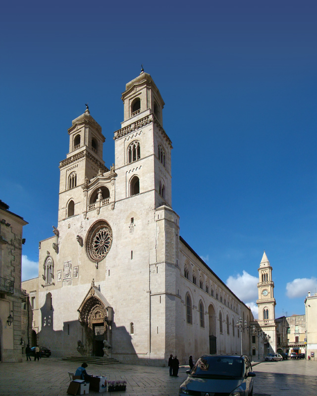
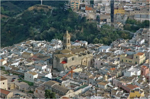
Матера (Matera, Matera)
.svg)
- коммуна Италии
 Hiking in Матера
Hiking in Matera, Italy, offers a unique blend of ancient history, stunning landscapes, and diverse trails. Nestled in the Basilicata region, Matera is famous for its "Sassi" districts—cave dwellings that have been inhabited for thousands of years. Here are some key points you should consider when hiking in and around Matera:
Trails and Areas to Explore
-
Sassi di Matera: Exploring the Sassi area itself can be an incredible hiking experience. The labyrinthine streets and ancient stone buildings provide a unique backdrop as you wander through this UNESCO World Heritage Site. While it’s not a typical hiking path, the terrain can be rugged, so good footwear is recommended.
-
Murgia National Park (Parco Nazionale dell'Alta Murgia): Located just outside Matera, this park features a range of hiking trails with stunning views, diverse wildlife, and interesting geological formations. Trails vary in difficulty, offering options for both beginner and experienced hikers. The park is also home to ancient rupestrian churches carved into rock faces.
-
Civita di Matera: This area features breathtaking views, steep cliffs, and paths that wind through nature. The trails take you through areas with rich Mediterranean flora and fauna, offering a peaceful and picturesque setting.
-
Via Ferrata: For the more adventurous hiker, there are also climbing opportunities in the area, such as via ferrata routes that combine hiking with climbing. These routes offer secure paths alongside more challenging aspects of the rock faces.
Seasonal Considerations
-
Spring and Fall: The best times to hike around Matera are typically in the spring (March to June) and fall (September to November). These seasons offer milder temperatures, making hiking more enjoyable.
-
Summer: Summer can be quite hot, so it is advisable to hike early in the morning or later in the evening to avoid the heat.
Tips for Hiking in Matera
-
Footwear: Wear good hiking shoes with proper traction, as many paths can be rocky and uneven.
-
Water and Snacks: Always carry enough water and snacks, especially if planning on hiking for several hours. There may not be many facilities along certain trails.
-
Check Local Maps: Make sure to have a map or a GPS app handy. While some trails are marked, others may not be clearly indicated.
-
Guided Tours: Consider local guided hikes to learn more about the history, geology, and flora of the area. This can greatly enhance your experience and provide safety on unfamiliar trails.
-
Respect Nature: Follow Leave No Trace principles, ensuring that you minimize your impact on the natural environment, especially in protected areas.
Hiking in and around Matera presents an opportunity to combine physical activity with the exploration of one of Italy's most incredible natural and cultural landscapes. Enjoy your adventure!
- Страна:

- Почтовый код: 75100
- Телефонный код: 0835
- Код автомобильного номера: MT
- Координаты: 40° 40' 0" N, 16° 36' 0" E


- GPS треки (wikiloc): [Ссылка]
- Высота над уровнем моря: 401 м m
- Площадь: 392.09 кв.км
- Население: 60351
- Веб сайт: http://www.comune.mt.it
- Википедия русская: wiki(ru)
- Википедия английская: wiki(en)
- Википедия национальная: wiki(it)
- Хранилище Wikidata: Wikidata: Q13616
- Галерея изображений в википедии: [Ссылка]
- Катеория в википедии: [Ссылка]
- код Freebase: [/m/0gbnt]
- код Freebase: [/m/0gbnt]
- код GeoNames: Альт: [6540110]
- код GeoNames: Альт: [6540110]
- код VIAF: Альт: [133160208]
- код VIAF: Альт: [133160208]
- ID отношения в OpenStreetMap: [40622]
- ID отношения в OpenStreetMap: [40622]
- код GND: Альт: [4237961-1]
- код GND: Альт: [4237961-1]
- место в MusicBrainz: [875846c0-bbd2-477c-aa8a-b60f25161083]
- место в MusicBrainz: [875846c0-bbd2-477c-aa8a-b60f25161083]
- код темы Quora: [Matera]
- код темы Quora: [Matera]
- UN/LOCODE: [ITMTR]
- UN/LOCODE: [ITMTR]
- код в энциклопедии «Британника онлайн»: [place/Matera-Italy]
- код в энциклопедии «Британника онлайн»: [place/Matera-Italy]
- код в Большой российской энциклопедии онлайн: [2192989]
- код в Большой российской энциклопедии онлайн: [2192989]
- код Pleiades: [442650]
- код Pleiades: [442650]
- код в Итальянской энциклопедии онлайн: [matera]
- код в Итальянской энциклопедии онлайн: [matera]
- код ISTAT: 077014
- код ISTAT: 077014
- кадастровый код Италии: F052
- кадастровый код Италии: F052
Граничит с регионами:

Альтамура
- коммуна Италии
Hiking in Альтамура
Altamura, located in the Apulia region of Italy, is renowned for its rich history, stunning landscapes, and unique geological features. Hiking in this area can be a rewarding experience for nature lovers, history enthusiasts, and anyone looking to immerse themselves in the beautiful Italian countryside. Here are some key points to consider when planning a hiking trip in Altamura:...
- Страна:
- Почтовый код: 70022
- Телефонный код: 080
- Код автомобильного номера: BA
- Координаты: 40° 49' 0" N, 16° 33' 0" E
- GPS треки (wikiloc): [Ссылка]
- Высота над уровнем моря: 467 м m
- Площадь: 431.38 кв.км
- Население: 70514
- Веб сайт: [Ссылка]


Гравина-ин-Пулья
- коммуна Италии
Hiking in Гравина-ин-Пулья
Gravina in Puglia, located in the Apulia region of southern Italy, offers a unique hiking experience that combines natural beauty, historical significance, and cultural heritage. The town is known for its stunning ravines that have been shaped by the Gravina River, creating dramatic landscapes ideal for adventurous hikers....
- Страна:
- Почтовый код: 70024
- Телефонный код: 080
- Код автомобильного номера: BA
- Координаты: 40° 49' 14" N, 16° 25' 24" E
- GPS треки (wikiloc): [Ссылка]
- Высота над уровнем моря: 367 м m
- Площадь: 384.73 кв.км
- Население: 43816
- Веб сайт: [Ссылка]


Сантерамо-ин-Колле
- коммуна Италии
Hiking in Сантерамо-ин-Колле
Santeramo in Colle is a charming town located in the Apulia region of Italy. It's surrounded by the stunning landscape of the Murgia area, which is characterized by rolling hills, rugged terrain, and a unique mix of natural and cultural heritage. Here are some key points about hiking in Santeramo in Colle:...
- Страна:
- Почтовый код: 70029
- Телефонный код: 080
- Код автомобильного номера: BA
- Координаты: 40° 48' 0" N, 16° 46' 0" E
- GPS треки (wikiloc): [Ссылка]
- Высота над уровнем моря: 489 м m
- Площадь: 144.86 кв.км
- Население: 26592
- Веб сайт: [Ссылка]


Джиноза
- коммуна Италии
Hiking in Джиноза
Ginosa, located in the Apulia region of Italy, is an excellent destination for hiking enthusiasts. The area is known for its unique landscapes, including rocky cliffs, the Gravina di Ginosa canyon, rural trails, and Mediterranean scrub....
- Страна:
- Почтовый код: 74025; 74013
- Телефонный код: 099
- Код автомобильного номера: TA
- Координаты: 40° 30' 0" N, 16° 45' 0" E
- GPS треки (wikiloc): [Ссылка]
- Высота над уровнем моря: 240 м m
- Площадь: 188.49 кв.км
- Население: 22430
- Веб сайт: [Ссылка]

Латерца
- коммуна в Италии
Hiking in Латерца
Hiking in Laterza, located in the Apulia region of southern Italy, offers a unique blend of natural beauty, historical significance, and cultural experiences. The area is known for its stunning landscapes, including limestone cliffs, ravines, and the beautiful Gravine di Laterza, which is part of a natural park....
- Страна:
- Почтовый код: 74014
- Телефонный код: 099
- Код автомобильного номера: TA
- Координаты: 40° 38' 0" N, 16° 48' 0" E
- GPS треки (wikiloc): [Ссылка]
- Высота над уровнем моря: 340 м m
- Площадь: 161.17 кв.км
- Население: 15171
- Веб сайт: [Ссылка]
Гроттоле
- коммуна Италии
Hiking in Гроттоле
Grottole is a charming village located in the Basilicata region of Southern Italy, known for its beautiful landscapes and rich historical heritage. It's a great spot for hiking enthusiasts looking to explore the natural beauty and cultural sites of this lesser-known area. Here are some key points about hiking in and around Grottole:...
- Страна:
- Почтовый код: 75010
- Телефонный код: 0835
- Код автомобильного номера: MT
- Координаты: 40° 36' 12" N, 16° 22' 42" E
- GPS треки (wikiloc): [Ссылка]
- Высота над уровнем моря: 481 м m
- Площадь: 117.15 кв.км
- Население: 2116
- Веб сайт: [Ссылка]


Мильонико
- коммуна Италии
Hiking in Мильонико
Miglionico is a charming village located in the Basilicata region of southern Italy, surrounded by beautiful landscapes and offering a variety of outdoor activities, including hiking. The area is characterized by its rolling hills, vineyards, and olive groves, as well as its rich history and cultural heritage....
- Страна:
- Почтовый код: 75010
- Телефонный код: 0835
- Код автомобильного номера: MT
- Координаты: 40° 34' 0" N, 16° 30' 0" E
- GPS треки (wikiloc): [Ссылка]
- Высота над уровнем моря: 465 м m
- Площадь: 88.84 кв.км
- Население: 2454
- Веб сайт: [Ссылка]

Монтескальозо
- коммуна Италии
Hiking in Монтескальозо
Montescaglioso is a charming town located in the Basilicata region of Southern Italy, known for its rich history and stunning landscapes. Hiking in and around Montescaglioso offers a great opportunity to explore the natural beauty of the area while experiencing its cultural heritage....
- Страна:
- Почтовый код: 75024
- Телефонный код: 0835
- Код автомобильного номера: MT
- Координаты: 40° 33' 0" N, 16° 40' 0" E
- GPS треки (wikiloc): [Ссылка]
- Высота над уровнем моря: 365 м m
- Площадь: 175.79 кв.км
- Население: 9877
- Веб сайт: [Ссылка]