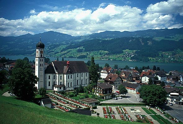
Гисвиль (Giswil, Giswil)

 Hiking in Гисвиль
Giswil is a beautiful village located in the Canton of Obwalden in Switzerland, surrounded by stunning mountains and offering a variety of hiking opportunities. Here are some highlights of hiking in and around Giswil:
Scenic Trails
-
Morgarten Ridge: This trail provides breathtaking views of Lake Sarnen and the surrounding mountains. It's a moderately challenging hike, ideal for those looking to experience the natural beauty of the region.
-
Giswilerstock: Hiking up to Giswilerstock is popular for its panoramic views of the entire Obwalden region. The ascent involves some steeper sections, making it a rewarding challenge for experienced hikers.
-
Quellenweg: This is a family-friendly hike that takes you along the sources of water in the area. It is an easier trail, perfect for young children or those looking for a leisurely walk.
Hiking Tips
- Season: The best time to hike in Giswil is during the late spring through early autumn months (May to October) when the weather is generally mild and the trails are accessible.
- Equipment: Depending on the trail, basic hiking gear is essential. For higher altitudes, ensure you have proper footwear, weather-appropriate clothing, and sufficient water.
- Navigation: While many trails are well-marked, it's always a good idea to carry a map or a GPS device to navigate effectively.
Local Advice
- Check the local weather forecast and trail conditions before heading out.
- If you are hiking solo, inform someone about your plans and expected return time.
- Respect the natural environment by sticking to designated trails and taking all your trash with you.
After Your Hike
Giswil offers charming local eateries and accommodations where you can relax and enjoy traditional Swiss cuisine after a day of hiking. The region is also known for its warm hospitality and beautiful landscapes, making it a great place to unwind.
Whether you're an experienced hiker or just looking for a pleasant walk, Giswil has trails that cater to a variety of skill levels and preferences, all set against a stunning backdrop. Enjoy your hiking adventure!
- Страна:

- Почтовый код: 6074
- Телефонный код: 041
- Код автомобильного номера: OW
- Координаты: 46° 50' 9" N, 8° 7' 8" E


- GPS треки (wikiloc): [Ссылка]
- Высота над уровнем моря: 1237 м m
- Площадь: 85.96 кв.км
- Население: 3651
- Веб сайт: http://www.giswil.ch
- Википедия русская: wiki(ru)
- Википедия английская: wiki(en)
- Википедия национальная: wiki(de)
- Хранилище Wikidata: Wikidata: Q69248
- Катеория в википедии: [Ссылка]
- код Freebase: [/m/01v1pr]
- код GeoNames: Альт: [7285921]
- код VIAF: Альт: [248252524]
- ID отношения в OpenStreetMap: [1683077]
- код GND: Альт: [4335848-2]
- идентификатор местоположения ArchINFORM: [7144]
- место в MusicBrainz: [3ebe5796-b992-441c-ab76-81e98750bcec]
- код TGN: [1064078]
- идентификатор HDS: [742]
- код швейцарского муниципалитета: [1403]
Граничит с регионами:

Флюли
Hiking in Флюли
Flühli is a picturesque municipality situated in the Canton of Lucerne, Switzerland. It's an excellent destination for hikers, offering a diverse range of trails amidst stunning Alpine scenery. Here are some highlights for hiking in Flühli:...
- Страна:
- Почтовый код: 6173
- Телефонный код: 041
- Код автомобильного номера: LU
- Координаты: 46° 50' 55" N, 8° 0' 37" E
- GPS треки (wikiloc): [Ссылка]
- Высота над уровнем моря: 1048 м m
- Площадь: 108.24 кв.км
- Население: 1956
- Веб сайт: [Ссылка]


Зарнен
Hiking in Зарнен
Sarnen, located in the Canton of Obwalden in Switzerland, is a picturesque destination for hiking enthusiasts. Nestled between beautiful mountains and a tranquil lake, Sarnen offers a variety of hiking trails suitable for different skill levels, making it an ideal spot for both beginners and experienced hikers....
- Страна:
- Почтовый код: 6060
- Телефонный код: 041
- Код автомобильного номера: OW
- Координаты: 46° 53' 49" N, 8° 14' 49" E
- GPS треки (wikiloc): [Ссылка]
- Высота над уровнем моря: 1309 м m
- Площадь: 70.01 кв.км
- Население: 10233
- Веб сайт: [Ссылка]


Лунгерн
Hiking in Лунгерн
Lungern is a beautiful village situated in the Swiss canton of Obwalden, nestled between the spectacular mountains and alongside the pristine Lungern-Turren Lake. The area offers a variety of hiking opportunities that cater to different skill levels, making it an excellent destination for both casual walkers and seasoned hikers. Here are some highlights of hiking in Lungern:...
- Страна:
- Почтовый код: 6078
- Телефонный код: 041
- Код автомобильного номера: OW
- Координаты: 46° 47' 14" N, 8° 9' 35" E
- GPS треки (wikiloc): [Ссылка]
- Высота над уровнем моря: 716 м m
- Площадь: 46.47 кв.км
- Население: 2122
- Веб сайт: [Ссылка]

Заксельн
Hiking in Заксельн
Sachseln is a beautiful village located in the Obwalden region of Switzerland, near the stunning Lake Sarnen and close to the city of Lucerne. Hiking in and around Sachseln offers a mix of scenic landscapes, cultural experiences, and opportunities for outdoor adventure....
- Страна:
- Почтовый код: 6072
- Телефонный код: 041
- Код автомобильного номера: OW
- Координаты: 46° 52' 4" N, 8° 14' 19" E
- GPS треки (wikiloc): [Ссылка]
- Высота над уровнем моря: 1634 м m
- Площадь: 53.86 кв.км
- Население: 5092
- Веб сайт: [Ссылка]

Хофштеттен-бай-Бриенц
Hiking in Хофштеттен-бай-Бриенц
Hofstetten bei Brienz is a picturesque village located in the Bernese Oberland region of Switzerland, renowned for its stunning natural landscapes and outdoor activities, including hiking. Here are some highlights and recommendations for hiking in and around Hofstetten bei Brienz:...
- Страна:
- Почтовый код: 3858
- Телефонный код: 033
- Код автомобильного номера: BE
- Координаты: 46° 45' 11" N, 8° 4' 34" E
- GPS треки (wikiloc): [Ссылка]
- Высота над уровнем моря: 646 м m
- Площадь: 8.7 кв.км
- Население: 531
- Веб сайт: [Ссылка]


Шванден-Бринц
- коммуна в кантоне Берн, Швейцария
Hiking in Шванден-Бринц
Schwanden bei Brienz is a charming village located in the Bernese Oberland region of Switzerland, nestled on the shores of Lake Brienz. It serves as a fantastic base for various outdoor activities, including hiking. The area is surrounded by stunning landscapes, including mountains, forests, and lakes, making it a hiker's paradise....
- Страна:
- Почтовый код: 3855
- Телефонный код: 033
- Код автомобильного номера: BE
- Координаты: 46° 44' 59" N, 8° 3' 0" E
- GPS треки (wikiloc): [Ссылка]
- Высота над уровнем моря: 659 м m
- Площадь: 7.02 кв.км
- Население: 603
- Веб сайт: [Ссылка]