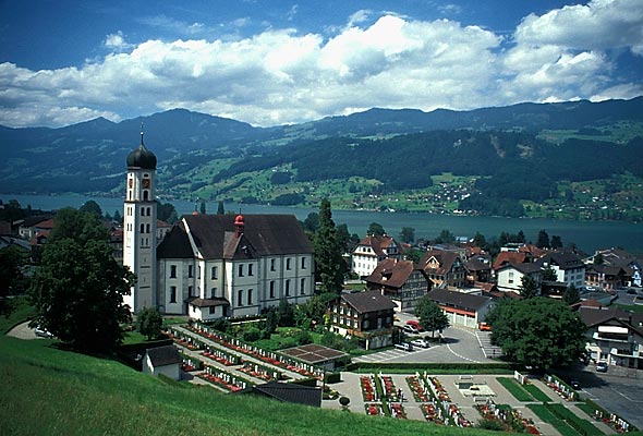
Лунгерн (Lungern, Lungern)

 Hiking in Лунгерн
Lungern is a beautiful village situated in the Swiss canton of Obwalden, nestled between the spectacular mountains and alongside the pristine Lungern-Turren Lake. The area offers a variety of hiking opportunities that cater to different skill levels, making it an excellent destination for both casual walkers and seasoned hikers. Here are some highlights of hiking in Lungern:
Hiking Trails
-
Lake Lungern Trail: This relatively easy circular trail takes you around Lake Lungern, providing stunning views of the water and surrounding mountains. It's a perfect hike for families and those looking for a leisurely stroll.
-
Turren Mountain Trail: This hike takes you to Turren, where you can enjoy panoramic views of the surrounding valleys and peaks. The trail can be steep in certain areas, making it more suitable for those with moderate fitness levels.
-
Lungern to Sörenberg Trail: For the more adventurous, this trail is longer and connects Lungern to the Sörenberg area. Hikers enjoy breathtaking alpine scenery, charming meadows, and a chance to spot wildlife.
-
Hiking to the Ahorn Peak: This is a more challenging hike that rewards you with magnificent views once you reach the summit. It's recommended for experienced hikers who are prepared for longer ascents.
Seasonal Considerations
- Summer: The ideal time for hiking, as trails are accessible and the weather is generally pleasant.
- Fall: Offers stunning autumn foliage and fewer crowds.
- Winter: Some trails might be suitable for snowshoeing or winter hiking, but check conditions before embarking.
- Spring: The melting snow can make trails muddy, so be prepared for changing conditions.
Tips for Hiking in Lungern
- Gear Up: Wear sturdy hiking boots and bring layers, as the weather can change rapidly in the mountains.
- Stay Hydrated: Always carry enough water, especially on longer hikes.
- Trail Map: Carry a map or use a hiking app to navigate the trails safely.
- Local Guidance: If you’re unsure about a trail, consider joining a local hiking group or guide.
Accessibility
Lungern is accessible by public transport, making it easy to reach from major Swiss cities. There are also facilities in the village, such as restaurants and accommodations, which provide a great base for your hiking adventures.
Safety
As with any outdoor activity, it’s essential to prioritize safety. Always inform someone of your hiking plans, check weather conditions before heading out, and be aware of your physical limits.
Whether you're looking for serene lakeside walks or challenging mountain hikes, Lungern has a bit of everything to offer for hiking enthusiasts. Enjoy your time in this breathtaking part of Switzerland!
- Страна:

- Почтовый код: 6078
- Телефонный код: 041
- Код автомобильного номера: OW
- Координаты: 46° 47' 14" N, 8° 9' 35" E


- GPS треки (wikiloc): [Ссылка]
- Высота над уровнем моря: 716 м m
- Площадь: 46.47 кв.км
- Население: 2122
- Веб сайт: http://www.lungern.ch
- Википедия русская: wiki(ru)
- Википедия английская: wiki(en)
- Википедия национальная: wiki(de)
- Хранилище Wikidata: Wikidata: Q64292
- Катеория в википедии: [Ссылка]
- код Freebase: [/m/01v1q6]
- код GeoNames: Альт: [2659828]
- код VIAF: Альт: [247366279]
- ID отношения в OpenStreetMap: [1683090]
- код GND: Альт: [4406244-8]
- идентификатор HDS: [744]
- код швейцарского муниципалитета: [1405]
Граничит с регионами:


Майринген
Hiking in Майринген
Meiringen, a charming town in the Bernese Oberland region of Switzerland, is an excellent base for hikers looking to explore the stunning landscapes of the Alps. Here are some key points about hiking in Meiringen:...
- Страна:
- Почтовый код: 3860
- Телефонный код: 033
- Код автомобильного номера: BE
- Координаты: 46° 43' 42" N, 8° 11' 10" E
- GPS треки (wikiloc): [Ссылка]
- Высота над уровнем моря: 600 м m
- Площадь: 40.7 кв.км
- Население: 4690
- Веб сайт: [Ссылка]

Заксельн
Hiking in Заксельн
Sachseln is a beautiful village located in the Obwalden region of Switzerland, near the stunning Lake Sarnen and close to the city of Lucerne. Hiking in and around Sachseln offers a mix of scenic landscapes, cultural experiences, and opportunities for outdoor adventure....
- Страна:
- Почтовый код: 6072
- Телефонный код: 041
- Код автомобильного номера: OW
- Координаты: 46° 52' 4" N, 8° 14' 19" E
- GPS треки (wikiloc): [Ссылка]
- Высота над уровнем моря: 1634 м m
- Площадь: 53.86 кв.км
- Население: 5092
- Веб сайт: [Ссылка]

Хофштеттен-бай-Бриенц
Hiking in Хофштеттен-бай-Бриенц
Hofstetten bei Brienz is a picturesque village located in the Bernese Oberland region of Switzerland, renowned for its stunning natural landscapes and outdoor activities, including hiking. Here are some highlights and recommendations for hiking in and around Hofstetten bei Brienz:...
- Страна:
- Почтовый код: 3858
- Телефонный код: 033
- Код автомобильного номера: BE
- Координаты: 46° 45' 11" N, 8° 4' 34" E
- GPS треки (wikiloc): [Ссылка]
- Высота над уровнем моря: 646 м m
- Площадь: 8.7 кв.км
- Население: 531
- Веб сайт: [Ссылка]


Бринцвилер
Hiking in Бринцвилер
Brienzwiler is a picturesque village located in the Bernese Oberland region of Switzerland, nestled between Lake Brienz and the towering peaks of the Alps. It's a fantastic destination for hiking enthusiasts, offering a variety of trails that cater to different skill levels, from leisurely walks to more challenging hikes. Here are some key points to consider when hiking in and around Brienzwiler:...
- Страна:
- Почтовый код: 3856
- Телефонный код: 033
- Код автомобильного номера: BE
- Координаты: 46° 45' 5" N, 8° 6' 8" E
- GPS треки (wikiloc): [Ссылка]
- Высота над уровнем моря: 1045 м m
- Площадь: 17.6 кв.км
- Население: 494
- Веб сайт: [Ссылка]

Кернс
Hiking in Кернс
Kerns is a picturesque area in Utah, known for its stunning landscapes and outdoor recreation opportunities, including hiking. Here are some key points about hiking in Kerns:...
- Страна:
- Почтовый код: 6064
- Телефонный код: 041
- Код автомобильного номера: OW
- Координаты: 46° 50' 23" N, 8° 18' 5" E
- GPS треки (wikiloc): [Ссылка]
- Высота над уровнем моря: 1017 м m
- Площадь: 92.58 кв.км
- Население: 6295
- Веб сайт: [Ссылка]

Гисвиль
Hiking in Гисвиль
Giswil is a beautiful village located in the Canton of Obwalden in Switzerland, surrounded by stunning mountains and offering a variety of hiking opportunities. Here are some highlights of hiking in and around Giswil:...
- Страна:
- Почтовый код: 6074
- Телефонный код: 041
- Код автомобильного номера: OW
- Координаты: 46° 50' 9" N, 8° 7' 8" E
- GPS треки (wikiloc): [Ссылка]
- Высота над уровнем моря: 1237 м m
- Площадь: 85.96 кв.км
- Население: 3651
- Веб сайт: [Ссылка]


Хаслиберг
Hiking in Хаслиберг
Hasliberg is a beautiful region located in the Bernese Oberland of Switzerland, famous for its stunning alpine landscapes and extensive network of hiking trails. Here are some key points to consider when hiking in Hasliberg:...
- Страна:
- Почтовый код: 6085
- Телефонный код: 033
- Код автомобильного номера: BE
- Координаты: 46° 44' 47" N, 8° 13' 42" E
- GPS треки (wikiloc): [Ссылка]
- Высота над уровнем моря: 1580 м m
- Площадь: 41.7 кв.км
- Население: 1183
- Веб сайт: [Ссылка]