Glay (Glay)

- коммуна во Франции
 Hiking in Glay
Hiking in Glay, located in the Doubs department of the Bourgogne-Franche-Comté region of France, offers a delightful experience amidst nature, characterized by diverse landscapes, lush greenery, and opportunities for wildlife observation.
Key Highlights:
-
Natural Scenery: The area around Glay features rolling hills, forests, and picturesque valleys. The regional flora and fauna provide a serene backdrop for hiking, making it a peaceful escape into nature.
-
Trail Variety: There are various hiking trails in and around Glay, catering to different skill levels. Routes range from easy walks suitable for families to more challenging hikes for seasoned enthusiasts. Local maps often help in navigating the trails.
-
Cultural Sites: While hiking, you might come across charming villages, historical sites, and local farms that add a cultural dimension to your trekking experience.
-
Wildlife Watching: The region is known for its biodiversity. Keep an eye out for various bird species, deer, and other wildlife as you explore the trails.
-
Accessibility: Glay is accessible by road and is located not far from larger towns, making it convenient for day trips or longer stays.
-
Seasonal Considerations: Each season offers a unique perspective. Spring and summer provide lush, vibrant scenery, while autumn showcases stunning fall colors. Winter hiking is also possible, though it may require additional gear.
-
Safety and Preparation: As with any hike, it’s important to prepare adequately. Wear suitable footwear, bring enough water and snacks, and check the weather forecast before you head out.
Tips for Hiking in Glay:
- Trail Maps: Always have a trail map or a GPS device to ensure you stay on track.
- Local Guides: Consider hiring a local guide if you want to learn more about the ecology and history of the area.
- Respect Nature: Adhere to the Leave No Trace principles to preserve the beauty of the landscape.
Hiking in Glay can be a fulfilling experience, offering a blend of adventure, beauty, and tranquility in the heart of the Doubs region. Enjoy your outdoor adventure!
- Страна:

- Почтовый код: 25310
- Координаты: 47° 24' 20" N, 6° 53' 25" E


- GPS треки (wikiloc): [Ссылка]
- Площадь: 6.49 кв.км
- Население: 347
- Википедия английская: wiki(en)
- Википедия национальная: wiki(fr)
- Хранилище Wikidata: Wikidata: Q834531
- Катеория в википедии: [Ссылка]
- код Freebase: [/m/062wv_]
- код GeoNames: Альт: [3015826]
- номер SIREN: [212502744]
- код BNF: [152525003]
- код VIAF: Альт: [150149101]
- код GND: Альт: [4621370-3]
- код BabelNet: [01130333n]
- код муниципалитета INSEE: 25274
Граничит с регионами:

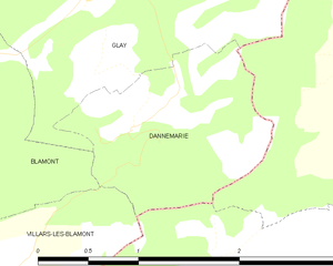
Dannemarie
Hiking in Dannemarie
Dannemarie, located in the Doubs department in the Bourgogne-Franche-Comté region of France, offers beautiful hiking opportunities through its picturesque landscapes, rolling hills, and forests. Here are some highlights and tips for hiking in the area:...
- Страна:
- Почтовый код: 25310
- Координаты: 47° 23' 25" N, 6° 53' 50" E
- GPS треки (wikiloc): [Ссылка]
- Площадь: 2.25 кв.км
- Население: 112


Blamont
- коммуна во Франции
Hiking in Blamont
Blamont is not a widely recognized hiking destination, and information about it may be limited or specific to regional trails. However, it's possible that Blamont refers to a local area in a specific region, possibly in France or another location....
- Страна:
- Почтовый код: 25310
- Координаты: 47° 23' 8" N, 6° 50' 53" E
- GPS треки (wikiloc): [Ссылка]
- Площадь: 10.06 кв.км
- Население: 1224


Abbévillers
- коммуна во Франции
Hiking in Abbévillers
Abbévillers is a charming commune located in the Doubs department in the Bourgogne-Franche-Comté region of eastern France. This area offers beautiful landscapes, rich nature, and numerous trails that cater to various hiking levels....
- Страна:
- Почтовый код: 25310
- Координаты: 47° 25' 53" N, 6° 55' 6" E
- GPS треки (wikiloc): [Ссылка]
- Площадь: 11.18 кв.км
- Население: 1026
- Веб сайт: [Ссылка]


Grandfontaine
Hiking in Grandfontaine
Grandfontaine is a small town in Switzerland, situated in the Jura Mountains, known for its picturesque landscapes and outdoor activities, including hiking. The Jura region offers a variety of hiking trails that cater to different skill levels, making it an excellent destination for both novice and experienced hikers....
- Страна:

- Почтовый код: 2908
- Телефонный код: 032
- Код автомобильного номера: JU
- Координаты: 47° 23' 0" N, 6° 56' 0" E
- GPS треки (wikiloc): [Ссылка]
- Высота над уровнем моря: 540 м m
- Площадь: 8.94 кв.км
- Население: 388
- Веб сайт: [Ссылка]


Meslières
- коммуна во Франции
Hiking in Meslières
Meslières is a picturesque village in the Haute-Saône department of France, nestled in the region of Bourgogne-Franche-Comté. This area is known for its beautiful landscapes, rolling hills, and lush forests, making it an excellent destination for hiking enthusiasts....
- Страна:
- Почтовый код: 25310
- Координаты: 47° 25' 2" N, 6° 53' 16" E
- GPS треки (wikiloc): [Ссылка]
- Площадь: 2.99 кв.км
- Население: 382


Roches-lès-Blamont
- коммуна во Франции
Hiking in Roches-lès-Blamont
Roches-lès-Blamont is a picturesque village located in the Doubs department of the Bourgogne-Franche-Comté region in eastern France. The area is surrounded by lush landscapes, making it an excellent destination for hiking enthusiasts....
- Страна:
- Почтовый код: 25310
- Координаты: 47° 24' 35" N, 6° 51' 5" E
- GPS треки (wikiloc): [Ссылка]
- Площадь: 5.44 кв.км
- Население: 643