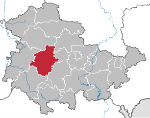
Гота (Gotha, Landkreis Gotha)
- район земли Тюрингия, Германия
Gotha district, located in the state of Thuringia in central Germany, offers a variety of hiking opportunities for nature enthusiasts and outdoor adventurers. The region is characterized by its picturesque landscapes, historical sites, and diverse ecosystems, making it a great destination for hiking.
Key Features of Hiking in Gotha District:
-
Scenic Trails: The district is home to numerous well-marked hiking trails that vary in difficulty. Popular areas to explore include the Thuringian Forest (Thüringer Wald), where you can find both easier paths suitable for families and more challenging routes for experienced hikers.
-
Historical Landmarks: As you hike through the district, you can encounter various historical sites, including castles, ruins, and charming villages that provide insight into the region's rich history. The Friedenstein Castle in Gotha is a notable landmark that adds cultural value to your hiking experience.
-
Nature Reserves: The area boasts several nature reserves that protect local flora and fauna. Places like the Arnstadt Forest are excellent for observing wildlife and enjoying the tranquility of nature.
-
Topographical Variety: The terrain ranges from rolling hills to dense forests and open meadows, ensuring that hikers can enjoy diverse scenery. The elevation changes make for rewarding views at higher altitudes.
-
Seasonal Hiking: Each season in Gotha district offers a unique hiking experience. Springtime features blooming flowers, summer provides lush vegetation, autumn showcases colorful foliage, and winter can offer snow-covered trails for a different perspective.
-
Access and Amenities: Many trails are easily accessible from local towns and cities, and you can find amenities such as cafes, rest areas, and information centers to help plan your hike.
Tips for Hiking in Gotha District:
- Proper Gear: Wear sturdy hiking boots and dress in layers, as weather conditions can change rapidly.
- Stay Hydrated: Carry enough water, especially on longer hikes, and consider packing some snacks.
- Trail Maps and Signage: Most trails are well-marked, but it's a good idea to carry a map or use a hiking app for navigation.
- Respect Nature: Follow Leave No Trace principles, stay on marked paths, and observe local wildlife from a distance.
With its combination of natural beauty, historical significance, and varied hiking opportunities, Gotha district is a wonderful destination for both casual walkers and seasoned hikers alike.
- Страна:

- Код автомобильного номера: GTH
- Координаты: 50° 55' 12" N, 10° 45' 0" E


- GPS треки (wikiloc): [Ссылка]
- Высота над уровнем моря: 338 м m
- Площадь: 936.08 кв.км
- Население: 136831
- Веб сайт: http://www.landkreis-gotha.de
- Википедия русская: wiki(ru)
- Википедия английская: wiki(en)
- Википедия национальная: wiki(de)
- Хранилище Wikidata: Wikidata: Q7869
- Галерея изображений в википедии: [Ссылка]
- Катеория в википедии: [Ссылка]
- код Freebase: [/m/01ph5t]
- код GeoNames: Альт: [2918750]
- код VIAF: Альт: [129080313]
- ID отношения в OpenStreetMap: [62468]
- код GND: Альт: [4423727-3]
- идентификатор местоположения ArchINFORM: [4553]
- код LCNAF: Альт: [n85307924]
- код TGN: [7184261]
- код NUTS: [DEG0C]
- код района Германии: 16067
Граничит с регионами:


Эрфурт
- город в земле Тюрингия, Германия
Hiking around Erfurt, the capital of Thuringia in central Germany, offers a unique blend of natural beauty and cultural experiences. The region is characterized by picturesque landscapes, rolling hills, and charming villages, as well as numerous trails suitable for all hiking levels. Here are some highlights to consider:...
- Страна:

- Почтовый код: 99099; 99098; 99097; 99096; 99095; 99094; 99092; 99091; 99090; 99089; 99087; 99086; 99085; 99084
- Телефонный код: 36204; 36203; 36202; 36208; 361
- Код автомобильного номера: EF; LF; L
- Координаты: 50° 58' 41" N, 11° 1' 45" E


- GPS треки (wikiloc): [Ссылка]
- Высота над уровнем моря: 194 м m
- Площадь: 269.91 кв.км
- Население: 211113
- Веб сайт: [Ссылка]

