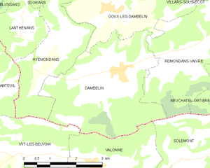
Goux-lès-Dambelin (Goux-lès-Dambelin)

- коммуна во Франции
 Hiking in Goux-lès-Dambelin
Goux-lès-Dambelin is a charming village located in the Doubs department in the Bourgogne-Franche-Comté region of eastern France. The surrounding area offers a variety of hiking opportunities that allow you to experience the natural beauty and local culture.
Hiking Trails:
-
Local Trails: There may be several marked trails in and around Goux-lès-Dambelin, suitable for different skill levels. These trails often pass through forests, meadows, and along rivers, providing picturesque views of the countryside.
-
Sentiers de Grande Randonnée (GR Trails): The region is part of larger hiking networks, which include long-distance paths like the GR 5 and GR 59. These trails can offer extended hiking options for those looking to explore further.
-
Nature Reserves: Nearby, you may find protected natural areas that provide a great opportunity for hiking while observing local wildlife and flora.
Points of Interest:
- Scenic Views: The trails often lead to elevated points with panoramic views of the surrounding countryside and the Jura mountains.
- Cultural Landmarks: As you hike, you might encounter small chapels, traditional farms, and historical landmarks reflecting local heritage.
Practical Tips:
- Trail Maps: It's advisable to obtain or download trail maps from local tourist offices or websites to ensure you stay on track.
- Appropriate Gear: Wear sturdy hiking boots and dress in layers, as weather can change quickly in this region.
- Hydrate and Snack: Bring enough water and snacks, especially if you plan to hike for several hours.
Best Time to Hike:
The best hiking seasons in this area typically span from late spring to early autumn, where the weather is generally mild and the trails are accessible.
Safety:
- Always inform someone about your hiking plans.
- Be aware of local wildlife and follow guidelines to ensure safety.
- Keep track of the time to avoid getting caught out after dark.
Whether you're looking for a leisurely walk or a more challenging hike, Goux-lès-Dambelin and its surroundings offer a delightful outdoor experience in the heart of the French countryside.
- Страна:

- Почтовый код: 25150
- Координаты: 47° 23' 48" N, 6° 40' 17" E


- GPS треки (wikiloc): [Ссылка]
- Площадь: 8.9 кв.км
- Население: 279
- Веб сайт: http://lapagelocale.com/25150-goux-les-dambelin
- Википедия английская: wiki(en)
- Википедия национальная: wiki(fr)
- Хранилище Wikidata: Wikidata: Q905217
- Катеория в википедии: [Ссылка]
- код Freebase: [/m/03mh9s8]
- код Freebase: [/m/03mh9s8]
- код GeoNames: Альт: [6429812]
- код GeoNames: Альт: [6429812]
- номер SIREN: [212502819]
- номер SIREN: [212502819]
- код BNF: [15252507h]
- код BNF: [15252507h]
- код тезауруса PACTOLS: [pcrtKGixm9AzDN]
- код тезауруса PACTOLS: [pcrtKGixm9AzDN]
- код муниципалитета INSEE: 25281
- код муниципалитета INSEE: 25281
Граничит с регионами:

Dambelin
- коммуна во Франции
Hiking in Dambelin
Dambelin is not a widely recognized hiking destination in my training data, and it's possible that it may be a lesser-known or local area. However, I can provide you with general information on how to approach hiking in any area and what to consider when exploring a new location....
- Страна:
- Почтовый код: 25150
- Координаты: 47° 22' 30" N, 6° 40' 33" E
- GPS треки (wikiloc): [Ссылка]
- Площадь: 12.43 кв.км
- Население: 484


Sourans
- коммуна во Франции
Hiking in Sourans
Sourans is a small village in the Hautes-Alpes region of France, known for its beautiful landscapes and proximity to the French Alps. While it may not be as well-known as larger hiking destinations, it offers a range of hiking opportunities for both beginners and experienced hikers....
- Страна:
- Почтовый код: 25250
- Координаты: 47° 24' 29" N, 6° 37' 56" E
- GPS треки (wikiloc): [Ссылка]
- Площадь: 4.2 кв.км
- Население: 122

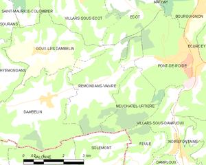
Rémondans-Vaivre
- коммуна во Франции
Hiking in Rémondans-Vaivre
Rémondans-Vaivre is a charming commune located in the eastern part of France, in the Doubs department. It offers a picturesque landscape that is great for hiking enthusiasts who want to explore the natural beauty and tranquility of the region. Here are a few highlights about hiking in Rémondans-Vaivre:...
- Страна:
- Почтовый код: 25150
- Координаты: 47° 22' 31" N, 6° 42' 48" E
- GPS треки (wikiloc): [Ссылка]
- Высота над уровнем моря: 365 м m
- Площадь: 9.19 кв.км
- Население: 233

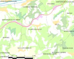
Villars-sous-Écot
- коммуна во Франции
Hiking in Villars-sous-Écot
Villars-sous-Écot is a charming village located in the French region of Bourgogne-Franche-Comté, near the border with Switzerland. The area is known for its picturesque landscapes and diverse hiking opportunities, making it a great destination for outdoor enthusiasts....
- Страна:
- Почтовый код: 25150
- Координаты: 47° 25' 18" N, 6° 41' 57" E
- GPS треки (wikiloc): [Ссылка]
- Площадь: 11.48 кв.км
- Население: 356
- Веб сайт: [Ссылка]


Saint-Maurice-Colombier
- коммуна во Франции
Hiking in Saint-Maurice-Colombier
Saint-Maurice-Colombier is located in the Doubs department in the Bourgogne-Franche-Comté region of France. It offers a picturesque backdrop for hikers, characterized by beautiful landscapes, dense forests, and rolling hills....
- Страна:
- Почтовый код: 25260
- Координаты: 47° 26' 31" N, 6° 38' 41" E
- GPS треки (wikiloc): [Ссылка]
- Высота над уровнем моря: 330 м m
- Площадь: 13.29 кв.км
- Население: 907
- Веб сайт: [Ссылка]